
Fitxer:Sedan Plowshare Crater.jpg
Mida d'aquesta previsualització: 755 × 599 píxels. Altres resolucions: 302 × 240 píxels | 605 × 480 píxels | 968 × 768 píxels | 1.280 × 1.016 píxels | 1.426 × 1.132 píxels.
Fitxer original (1.426 × 1.132 píxels, mida del fitxer: 202 Ko, tipus MIME: image/jpeg)
| Aquest fitxer i la informació mostrada a continuació provenen del dipòsit multimèdia lliure Wikimedia Commons. |
|
This is an image of a place or building that is listed on the National Register of Historic Places in the United States of America. Its reference number is 94000183. |
| Descripció |
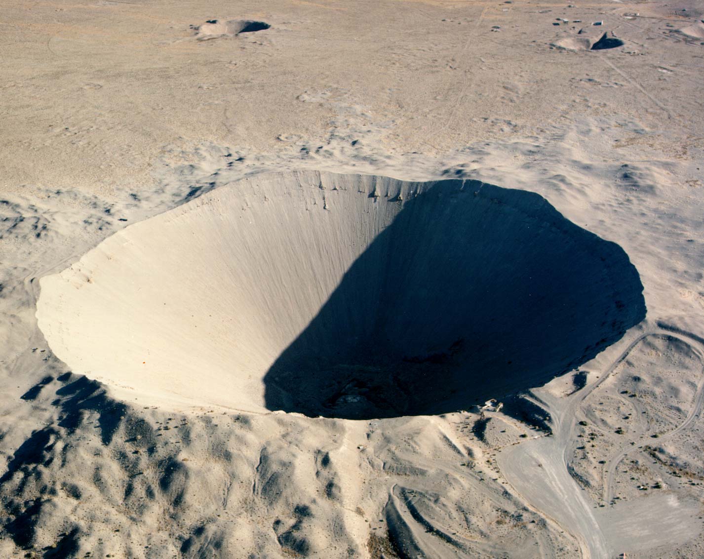
English: Crater from the 1962 "Sedan" nuclear test as part of Operation Plowshare. The 104 kiloton blast displaced 12 million tons of earth and created a crater 320 feet deep and 1,280 feet wide. (Look to the size of the roads in the bottom-right of the picture, and the observation deck at the lower-right edge of the crater, for a sense of scale) العربية: فوهة بركان سيدان هي نتيجة اختبار سيدان النووي ويقع داخل موقع اختبار نيفادا، على بعد 12 ميلاً (19 كم) جنوب غرب بحيرة جرووم |
|
| Font |
|
|
| Autor | Federal Government of the United States |
| Posició de la càmera | | Aquesta i altres imatges properes a: OpenStreetMap |
|---|
Aquesta imatge va ser escollida imatge del dia el 27 January 2006. La seva descripció va ser la següent: English: Crater from a nuclear test at Nevada Test Site. Altres idiomes:
Čeština: Kráter po zkušebním jaderném výbuchu v Nevadě. Cymraeg: Crater oddiwrth brawf niwcliar yn y Seit Profi Nevada. Dansk: Krater fra en kernevåben-test i testområdet i Nevada, USA. Deutsch: Krater von einem Nukleartest auf dem Nevadatestgelände English: Crater from a nuclear test at Nevada Test Site. Italiano: Cratere provocato da un test nucleare nel Nevada Test Site. Magyar: Egy nukleáris robbantás krátere. Nevada, USA. Nederlands: Krater als gevolg van een nucleaire test op de testvlakte in Nevada. Polski: Krater w strefie testów nuklearnych w stanie Nevada Slovenščina: Krater jedrskega preizkusa na preizkuševalnem območju Nevada. ગુજરાતી : નેવાડાના ન્યુક્લિયર પરિક્ષણ મથક પર ભૂગર્ભ પરિક્ષણ બાદ રહેલો ખાડો. 한국어: 네바다 핵실험 장소에 있는 폭탄 구멍. العربية : حفرة هائلة جراء انفجار نووي في منطقة الاختبارات النووية بولاية نيفادا الأمريكية |
Aquesta obra és en el domini públic als Estats Units perquè és una obra del govern federal dels Estats Units sota els termes del Títol 17, Capítol 1, Secció 105 del Codi dels EUA. Vegeu drets d'autor.
Nota: Això només s'aplica a obres del Govern Federal i no a les dels estats individuals ni cap altra subdivisió administrativa. Aquesta plantilla tampoc no s'aplica a dissenys de segells de correus publicats pel Servei Postal dels Estats Units des de 1978 (vegeu 206.02(b) of Compendium II: Copyright Office Practices).
|
 | |
| Aquest fitxer està identificat com a lliure de restriccions conegudes sota la llei de drets d'autor, inclosos els drets veïns. | ||
Historial del fitxer
Cliqueu una data/hora per veure el fitxer tal com era aleshores.
| Data/hora | Miniatura | Dimensions | Usuari/a | Comentari | |
|---|---|---|---|---|---|
| actual | 19:49, 11 des 2005 | | 1.426 × 1.132 (202 Ko) | Fastfission~commonswiki | even higher res |
| 22:30, 22 maig 2005 |  | 685 × 543 (338 Ko) | Xenoforme~commonswiki |
Ús del fitxer
Les 4 pàgines següents utilitzen aquest fitxer:
Ús global del fitxer
Utilització d'aquest fitxer en altres wikis:
- Utilització a af.wikipedia.org
- Utilització a ar.wikipedia.org
- Utilització a beta.wikiversity.org
- Utilització a bg.wikipedia.org
- Utilització a ceb.wikipedia.org
- Utilització a cs.wikipedia.org
- Utilització a de.wikipedia.org
- Utilització a de.wiktionary.org
- Utilització a en.wikipedia.org
- Nuclear explosive
- Nevada Test Site
- Project Plowshare
- Nuclear weapons testing
- Sedan (nuclear test)
- Wikipedia:Recent additions 26
- Peaceful nuclear explosion
- Underground nuclear weapons testing
- Craterization
- Yucca Flat
- Explosion crater
- Wikipedia:Did you know/Statistics/Monthly DYK pageview leaders/2008
- Wikipedia:Recent additions/2005/March
- User:Binksternet/DYK
- Wikipedia:Recent additions/2008/July
- July 1962
- National Register of Historic Places listings in Nye County, Nevada
- User:Boundarylayer/sandbox
- User:Epicgenius/Userpage/Rest of year
- Crater
- User:Ikluft/essay/Categorization of craters
- History of the Petroleum industry in Alberta
- Utilització a en.wikibooks.org
- Utilització a en.wikiversity.org
Vegeu més usos globals d'aquest fitxer.