
Fitxer:St. John, U.S. Virgin Islands.jpg

Mida d'aquesta previsualització: 600 × 600 píxels. Altres resolucions: 240 × 240 píxels | 480 × 480 píxels | 768 × 768 píxels | 1.024 × 1.024 píxels | 2.400 × 2.400 píxels.
Fitxer original (2.400 × 2.400 píxels, mida del fitxer: 2,74 Mo, tipus MIME: image/jpeg)
| Aquest fitxer i la informació mostrada a continuació provenen del dipòsit multimèdia lliure Wikimedia Commons. |
Resum
| Descripció |
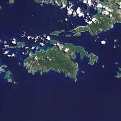
English: Natural-colour image of the Island of St. John island in the United States Virgin Islands.
|
| Data | |
| Font | NASA Earth Observatory |
| Autor | Jesse Allen and Robert Simmon |
| Altres versions |


.jpg)

Image captured by the Advanced Land Imager (ALI) on NASA’s Earth Observing-1 (EO-1) satellite. EO-1 ALI data provided courtesy of the NASA EO-1 team.
Llicència
| Aquest fitxer és en el domini públic perquè ha estat creat per la NASA. L'avís legal de la NASA diu que «el material de la NASA no està protegit per copyright si no es diu el contrari». (NASA copyright policy page o JPL Image Use Policy). | ||
 |
Atenció:
|
| Anotacions | Aquesta imatge té anotacions: Vegeu-les a Commons |
Historial del fitxer
Cliqueu una data/hora per veure el fitxer tal com era aleshores.
| Data/hora | Miniatura | Dimensions | Usuari/a | Comentari | |
|---|---|---|---|---|---|
| actual | 12:13, 20 gen 2011 | | 2.400 × 2.400 (2,74 Mo) | Originalwana | {{Information |Description={{en|1=Natural-colour image of the eastern half of St. John. Settlements—marked by curving roads and light roofs—line the irregular coastline. The pinpoints of white in Coral Bay are probably boats. The island’s interior |
Ús del fitxer
La pàgina següent utilitza aquest fitxer:
Ús global del fitxer
Utilització d'aquest fitxer en altres wikis:
- Utilització a arz.wikipedia.org
- Utilització a ast.wikipedia.org
- Utilització a ceb.wikipedia.org
- Utilització a cy.wikipedia.org
- Utilització a en.wikipedia.org
- Utilització a en.wikisource.org
- Utilització a eo.wikipedia.org
- Utilització a es.wikipedia.org
- Utilització a eu.wikipedia.org
- Utilització a fi.wikipedia.org
- Utilització a frr.wikipedia.org
- Utilització a fr.wikivoyage.org
- Utilització a gl.wikipedia.org
- Utilització a id.wikipedia.org
- Utilització a lb.wikipedia.org
- Utilització a pl.wikipedia.org
- Utilització a tg.wikipedia.org
- Utilització a tl.wikipedia.org
- Utilització a uk.wikipedia.org
- Utilització a vec.wikipedia.org
- Utilització a www.wikidata.org