
Fitxer:St Sebastian's School - (now L'Arche ) Lockerby Road - geograph.org.uk - 930388.jpg
St_Sebastian's_School_-_(now_L'Arche_)_Lockerby_Road_-_geograph.org.uk_-_930388.jpg (640 × 480 píxels, mida del fitxer: 72 Ko, tipus MIME: image/jpeg)
| Aquest fitxer i la informació mostrada a continuació provenen del dipòsit multimèdia lliure Wikimedia Commons. |
_Lockerby_Road_-_geograph.org.uk_-_930388.jpg?uselang=ca)
Resum
| Descripció |
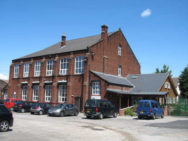
English: St Sebastian's School - (now LArche ) Lockerby Road St Sebastian's School first opened in May 1909 with 131 pupils. The school moved to a new building in Holly Road in 1980 but the old school is still in use today by the L"Arche community.
"LArche Liverpool is Christian Community of 150 people in central Liverpool where people with and without learning disabilities live and work together. It was a Dominican priest called Père Thomas Philippe who helped Jean Vanier 'begin something' with people with learning disabilities, about 40 years ago in France. Jean, originally an officer in the Royal Navy, had become an academic in Canada, but he felt increasingly called to this different life. He met two men called Raphael Simi and Philippe Seux who were living in a large institution near Paris - the only home they'd known for many years. Jean invited them to come and make a home with him. He knew he could not help everyone, but that by helping a few, together they might be a sign to others. L'Arche first arrived in the UK in 1974 with help from Jean's sister, Thérèse, a London doctor. The first community opened in Kent. There are now nine communities in the UK." Information taken from the website below: http://www.larcheliverpool.org/index.php |
| Data | |
| Font | From geograph.org.uk |
| Autor | Sue Adair |
| Reconeixement (required by the license) | Sue Adair / St Sebastian's School - (now L’Arche ) Lockerby Road / |
| Posició de la càmera | | Aquesta i altres imatges properes a: OpenStreetMap |
|---|
_Lockerby_Road_-_geograph.org.uk_-_930388.jpg¶ms=053.412240_N_-002.940300_E_globe:Earth_type:camera_source:geograph-osgb36(SJ37599101)_heading:67.00&language=ca)
| Posició de l'objecte | | Aquesta i altres imatges properes a: OpenStreetMap |
|---|
_Lockerby_Road_-_geograph.org.uk_-_930388.jpg¶ms=053.412420_N_-002.939600_E_globe:Earth_class:object_type:object_source:geograph-osgb36(SJ37649103)_heading:67.00&language=ca)
Llicència

|
Aquesta imatge prové de la col·lecció del projecte Geograph British Isles. Vegeu la pàgina d'aquesta fotografia al lloc web Geograph per a més informació del fotògraf. El titular dels drets d'autor d'aquesta imatge és Sue Adair i autoritza utilitzar-la sota la llicència Reconeixement-CompartirIgual 2.0 de Creative Commons.
|
- Sou lliure de:
- compartir – copiar, distribuir i comunicar públicament l'obra
- adaptar – fer-ne obres derivades
- Amb les condicions següents:
- reconeixement – Heu de donar la informació adequada sobre l'autor, proporcionar un enllaç a la llicència i indicar si s'han realitzat canvis. Podeu fer-ho amb qualsevol mitjà raonable, però de cap manera no suggereixi que l'autor us dóna suport o aprova l'ús que en feu.
- compartir igual – Si modifiqueu, transformeu, o generareu amb el material, haureu de distribuir les vostres contribucions sota una llicència similar o una de compatible com l'original
Historial del fitxer
Cliqueu una data/hora per veure el fitxer tal com era aleshores.
| Data/hora | Miniatura | Dimensions | Usuari/a | Comentari | |
|---|---|---|---|---|---|
| actual | 09:41, 22 feb 2011 | | 640 × 480 (72 Ko) | GeographBot | == {{int:filedesc}} == {{Information |description={{en|1=St Sebastian's School - (now LArche ) Lockerby Road St Sebastian's School first opened in May 1909 with 131 pupils. The school moved to a new building in Holly Road in 1980 but the old school is |
Ús del fitxer
La pàgina següent utilitza aquest fitxer:
_Lockerby_Road_-_geograph.org.uk_-_930388.jpg)