
Fitxer:Suhongtu site - Sinornithomimus quarry.png

Mida d'aquesta previsualització: 800 × 529 píxels. Altres resolucions: 320 × 211 píxels | 640 × 423 píxels | 1.147 × 758 píxels.
Fitxer original (1.147 × 758 píxels, mida del fitxer: 496 Ko, tipus MIME: image/png)
| Aquest fitxer i la informació mostrada a continuació provenen del dipòsit multimèdia lliure Wikimedia Commons. |
Resum
| Descripció |
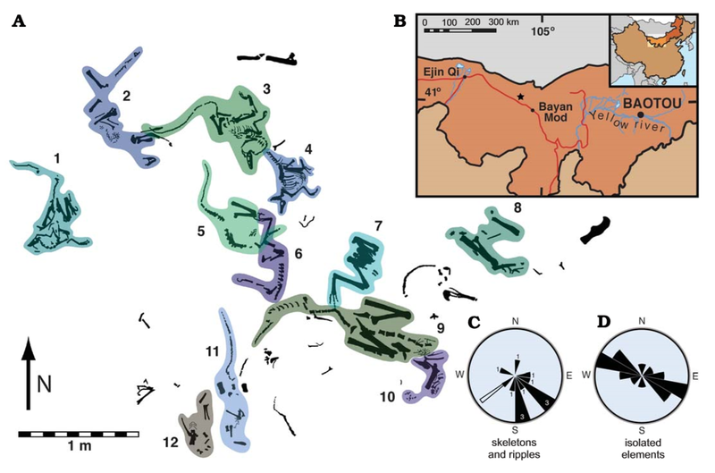
English: Suhongtu site, partial quarry map, locality map, and orientation data. A. Map of the central and northern portions of site showing the position of 12 of 13 skeletons. Skeletons 3 and 4 enlarged in Fig. 3. B. Fossil locality (41°17’ 10”N, 103°52’38”E) located 90 km northwest of Bayan Mod, InnerMongolia, China. C. Rose−diagram showing trends for skeletons (black, numbers denote skeleton count) and ripples (white). D. Mirror rose−diagram of elongated, isolated elements (n=13). Trends of skeletons have a strong, non−random (p<0.002) alignment to southeast. Flow direction of ripples is roughly perpendicular to that of elongate elements. |
| Data | |
| Font | (2008). "Mud-Trapped Herd Captures Evidence of Distinctive Dinosaur Sociality". Acta Palaeontologica Polonica 53 (4): 567–578. DOI:10.4202/app.2008.0402. ISSN 0567-7920. |
| Autor | David J. Varricchio, Paul C. Sereno, Zhao Xi-jin, Tan Lin Jeffrey A. Wilson & Gabrielle H. Lyon |
Llicència
This file is licensed under the Creative Commons Attribution 4.0 International license.
- Sou lliure de:
- compartir – copiar, distribuir i comunicar públicament l'obra
- adaptar – fer-ne obres derivades
- Amb les condicions següents:
- reconeixement – Heu de donar la informació adequada sobre l'autor, proporcionar un enllaç a la llicència i indicar si s'han realitzat canvis. Podeu fer-ho amb qualsevol mitjà raonable, però de cap manera no suggereixi que l'autor us dóna suport o aprova l'ús que en feu.
Historial del fitxer
Cliqueu una data/hora per veure el fitxer tal com era aleshores.
| Data/hora | Miniatura | Dimensions | Usuari/a | Comentari | |
|---|---|---|---|---|---|
| actual | 07:28, 21 ago 2020 | | 1.147 × 758 (496 Ko) | PaleoNeolitic | {{Information |description ={{en|1=Suhongtu site, partial quarry map, locality map, and orientation data. '''A'''. Map of the central and northern portions of site showing the position of 12 of 13 skeletons. Skeletons 3 and 4 enlarged in Fig. 3. '''B'''. Fossil locality (41°17’ 10”N, 103°52’38”E) located 90 km northwest of Bayan Mod, InnerMongolia, China. '''C'''. Rose−diagram showing trends for skeletons (black, numbers denote skeleton count) and ripples (white). '''D'''. Mirror rose−diagr... |
Ús del fitxer
La pàgina següent utilitza aquest fitxer:
Ús global del fitxer
Utilització d'aquest fitxer en altres wikis:
- Utilització a ar.wikipedia.org
- Utilització a cs.wikipedia.org
- Utilització a en.wikipedia.org
- Utilització a he.wikipedia.org
- Utilització a hu.wikipedia.org
- Utilització a sv.wikipedia.org
- Utilització a www.wikidata.org
- Utilització a zh.wikipedia.org