
Fitxer:Tuxer Alpen Karte.png

Mida d'aquesta previsualització: 661 × 600 píxels. Altres resolucions: 265 × 240 píxels | 529 × 480 píxels | 846 × 768 píxels | 1.129 × 1.024 píxels | 2.257 × 2.048 píxels | 4.847 × 4.398 píxels.
Fitxer original (4.847 × 4.398 píxels, mida del fitxer: 3,51 Mo, tipus MIME: image/png)
| Aquest fitxer i la informació mostrada a continuació provenen del dipòsit multimèdia lliure Wikimedia Commons. |
Resum
| Descripció |
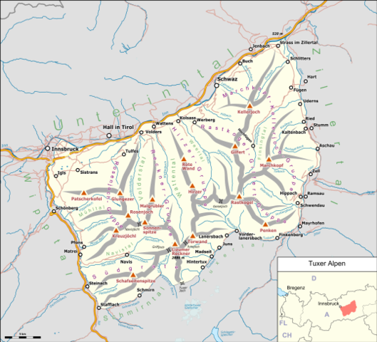
Deutsch: Übersichtskarte der Tuxer Alpen. |
|||||||||
| Data | ||||||||||
| Font |
Treball propi Map was created using:
|
|||||||||
| Creador |
|
|||||||||
| Permís (Com reutilitzar aquest fitxer) |
Map data (c) OpenStreetMap (and) contributors, CC-BY-SA | |||||||||
| Geotemporal data | ||||||||||
| Bounding box |
|
|||||||||
| Georeferencing | ||||||||||
| This work is licensed under the Open Database License (summary). |
Historial del fitxer
Cliqueu una data/hora per veure el fitxer tal com era aleshores.
| Data/hora | Miniatura | Dimensions | Usuari/a | Comentari | |
|---|---|---|---|---|---|
| actual | 18:42, 16 juny 2018 | | 4.847 × 4.398 (3,51 Mo) | Pechristener | Schrift vom Tuxertal war verdeckt. |
| 18:35, 16 juny 2018 |  | 4.847 × 4.398 (3,51 Mo) | Pechristener | Orte und Ortsteile der Gemeinde Tux dargestellt. | |
| 23:52, 14 juny 2018 |  | 4.840 × 4.391 (3,47 Mo) | Pechristener | Location map added | |
| 23:21, 14 juny 2018 |  | 4.840 × 4.391 (3,48 Mo) | Pechristener | == {{int:filedesc}} == {{Map |Description={{de|1=Übersichtskarte der {{w|Tuxer Alpen||de}}. }} |Source ={{own}} Map was created using: *[http://www.openstreetmap.org/ Open Street Map] Data *{{w|Austria location map.svg}} for location map |Author = *Hauptkarte: Pechristener *{{w|Austria location map.svg}} : NordNordWest, {{u|Lencer}} |Date =2017-06-14 |Permission =Map data (c) OpenStreetMap (and) contributors, CC-BY... |
Ús del fitxer
La pàgina següent utilitza aquest fitxer:
Ús global del fitxer
Utilització d'aquest fitxer en altres wikis:
- Utilització a arz.wikipedia.org
- Utilització a de.wikipedia.org
- Utilització a es.wikipedia.org
- Utilització a fr.wikipedia.org
- Utilització a it.wikipedia.org
- Utilització a nl.wikipedia.org
- Utilització a www.wikidata.org