
Fitxer:USA Illinois location map.svg

Mida d'aquesta previsualització PNG del fitxer SVG: 453 × 599 píxels. Altres resolucions: 181 × 240 píxels | 363 × 480 píxels | 580 × 768 píxels | 774 × 1.024 píxels | 1.548 × 2.048 píxels | 945 × 1.250 píxels.
Fitxer original (fitxer SVG, nominalment 945 × 1.250 píxels, mida del fitxer: 780 Ko)
| Aquest fitxer i la informació mostrada a continuació provenen del dipòsit multimèdia lliure Wikimedia Commons. |
Resum
| Descripció |
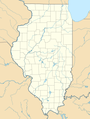
Quadratische Plattkarte, N-S-Streckung 130.0 %. Geographische Begrenzung der Karte:
Equirectangular projection, N/S stretching 130.0 %. Geographic limits of the map:
|
| Data | |
| Font | Treball propi |
| Autor | Alexrk2 |
| Altres versions |
Derivative works of this file: Derivative works of this file: |

|
This map has been made or improved in the German Kartenwerkstatt (Map Lab). You can propose maps to improve as well.
|
Llicència
Jo, el titular dels drets d'autor d'aquest treball, el public sota les següents llicències:

|
S'autoritza la còpia, la distribució i la modificació d'aquest document sota els termes de la llicència de documentació lliure GNU versió 1.2 o qualsevol altra versió posterior que publiqui la Free Software Foundation; sense seccions invariants, ni textos de portada, ni textos de contraportada. S'inclou una còpia d'aquesta llicència en la secció titulada GNU Free Documentation License. |
Aquest fitxer està subjecte a la llicència de Creative Commons Reconeixement 3.0 No adaptada.
- Sou lliure de:
- compartir – copiar, distribuir i comunicar públicament l'obra
- adaptar – fer-ne obres derivades
- Amb les condicions següents:
- reconeixement – Heu de donar la informació adequada sobre l'autor, proporcionar un enllaç a la llicència i indicar si s'han realitzat canvis. Podeu fer-ho amb qualsevol mitjà raonable, però de cap manera no suggereixi que l'autor us dóna suport o aprova l'ús que en feu.
Podeu seleccionar la llicència que vulgueu.
Historial del fitxer
Cliqueu una data/hora per veure el fitxer tal com era aleshores.
| Data/hora | Miniatura | Dimensions | Usuari/a | Comentari | |
|---|---|---|---|---|---|
| actual | 18:59, 10 jul 2009 | | 945 × 1.250 (780 Ko) | Alexrk2 | == Beschreibung == {{Information |Description= {{de|Positionskarte von Illinois, USA}} Quadratische Plattkarte, N-S-Streckung 130.0 %. Geographische Begrenzung der Karte: * N: 42.7° N * S: 36.8° N * W: 92.2° W * O: 86.4° W |
Ús del fitxer
Les 2 pàgines següents utilitzen aquest fitxer:
Ús global del fitxer
Utilització d'aquest fitxer en altres wikis:
- Utilització a als.wikipedia.org
- Utilització a an.wikipedia.org
- Utilització a ar.wikipedia.org
- Utilització a azb.wikipedia.org
- مندوتا، ایلینوی
- بلو آیلند، ایلینوی
- پولو، ایلینوی
- روشل، ایلینوی
- آنا، ایلینوی
- اوربانا، ایلینوی
- اورقون، ایلینوی
- ساووی، ایلینوی
- قرند دیتور، ایلینوی
- وست یونیون، ایلینوی
- آیوسدال
- استل، ایلینوی
- چانا، ایلینوی
- بیلیویل، ایلینوی
- ایقان، ایلینوی
- لیندنوود، ایلینوی
- ووسانق، ایلینوی
- ماسویل، ایلینوی
- پساتوم، ایلینوی
- اورقرین پارک، ایلینوی
- توماسبورو، ایلینوی
- تولونو، ایلینوی
- پاینز پوینت، ایلینوی
- فلاج، ایلینوی
- سیدنئی، ایلینوی
- ایست.جوزف، ایلینوی
- Utilització a az.wikipedia.org
- Utilització a be.wikipedia.org
- Utilització a bg.wikipedia.org
- Utilització a bn.wikipedia.org
- Utilització a ceb.wikipedia.org
- Utilització a ce.wikipedia.org
- Utilització a cs.wikipedia.org
Vegeu més usos globals d'aquest fitxer.