
Fitxer:USGS orthophoto of North Brother Island and South Brother Island - Bronx County.png

Mida d'aquesta previsualització: 308 × 600 píxels. Altres resolucions: 123 × 240 píxels | 246 × 480 píxels | 846 × 1.648 píxels.
Fitxer original (846 × 1.648 píxels, mida del fitxer: 1,77 Mo, tipus MIME: image/png)
| Aquest fitxer i la informació mostrada a continuació provenen del dipòsit multimèdia lliure Wikimedia Commons. |
Resum
| Descripció | |
| Data | Acquired in march 2006; published by USGS in 2008; converted and uploaded to Commons on April 22, 2009. |
| Font |
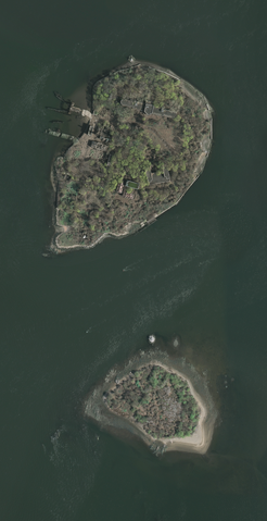
The National Map Seamless Server, layer New York City (Mar 2006), latitude 40.79433919 to 40.80337576, longitude -73.90149724 to -73.89540822. Converted from GeoTIFF to PNG using GIMP. |
| Autor | U.S. Geological Survey, conversion to PNG by uploader (Herr Satz). |
Llicència
Aquesta imatge és de domini públic, ja que conté materials que originalment van venir del Servei Geològic dels Estats Units d'Amèrica, una agència del Departament de l'Interior dels Estats Units. Per a obtenir més informació, consulti la política oficial de drets de l'USGS.
|
Historial del fitxer
Cliqueu una data/hora per veure el fitxer tal com era aleshores.
| Data/hora | Miniatura | Dimensions | Usuari/a | Comentari | |
|---|---|---|---|---|---|
| actual | 19:04, 22 abr 2009 | | 846 × 1.648 (1,77 Mo) | Herr Satz | {{Information |Description={{en|1=Orthophoto of North Brother and South Brother islands.}} |Source=[http://gisdata.usgs.net/website/seamless/viewer.htm ''The National Map'' Seamless Se |
Ús del fitxer
No hi ha pàgines que utilitzin aquest fitxer.
Ús global del fitxer
Utilització d'aquest fitxer en altres wikis:
- Utilització a de.wikipedia.org
- Utilització a es.wikipedia.org
- Utilització a et.wikipedia.org
- Utilització a fr.wikipedia.org
- Utilització a he.wikipedia.org