
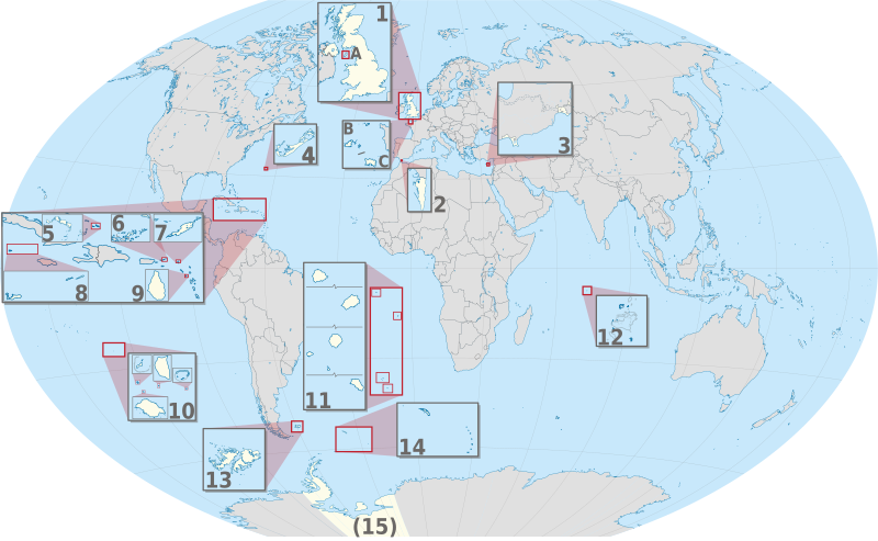
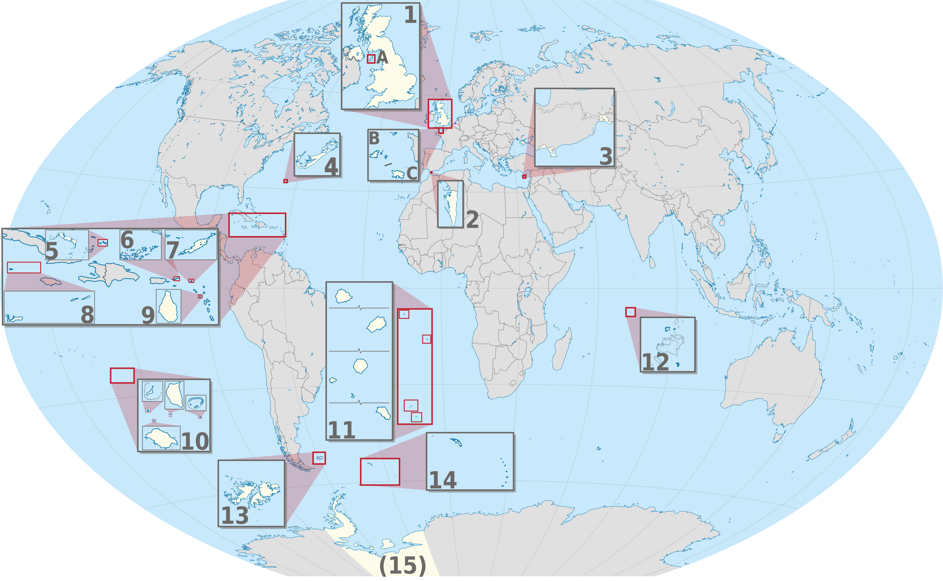
Fitxer:United Kingdom (overseas+crown dependencies), administrative divisions - Nmbrs (multiple zoom).svg

Mida d'aquesta previsualització PNG del fitxer SVG: 800 × 493 píxels. Altres resolucions: 320 × 197 píxels | 640 × 394 píxels | 1.024 × 631 píxels | 1.280 × 789 píxels | 2.560 × 1.577 píxels | 3.188 × 1.964 píxels.
Fitxer original (fitxer SVG, nominalment 3.188 × 1.964 píxels, mida del fitxer: 6,04 Mo)
| Aquest fitxer i la informació mostrada a continuació provenen del dipòsit multimèdia lliure Wikimedia Commons. |
Resum


.svg)


_(Paris_zoom).svg)
.svg)
,_administrative_divisions_-_de_-_colored_(multizoom).svg)
_-_colored.svg)
.svg)
,_administrative_divisions_-_Nmbrs_(multizoom).svg)
,_administrative_divisions_-_de_-_colored.svg)
_-_de_-_colored.svg)

.svg)

.svg)
,_administrative_divisions_-_Nmbrs_(multiple_zoom).svg?uselang=ca)
_(W3).svg)
Llicència
Jo, el titular dels drets d'autor d'aquest treball, el public sota la següent llicència:
Aquest fitxer està publicat sota la llicència de Creative Commons Reconeixement i Compartir Igual 2.0 Genèrica.
- Sou lliure de:
- compartir – copiar, distribuir i comunicar públicament l'obra
- adaptar – fer-ne obres derivades
- Amb les condicions següents:
- reconeixement – Heu de donar la informació adequada sobre l'autor, proporcionar un enllaç a la llicència i indicar si s'han realitzat canvis. Podeu fer-ho amb qualsevol mitjà raonable, però de cap manera no suggereixi que l'autor us dóna suport o aprova l'ús que en feu.
- compartir igual – Si modifiqueu, transformeu, o generareu amb el material, haureu de distribuir les vostres contribucions sota una llicència similar o una de compatible com l'original

|
I'd greatly appreciate, that you attribute this media file to Wikimedia Commons, if used outside Wikipedia or Commons. For use in publications such as books, newspapers, blogs, websites, please insert here the following line:
|
,_administrative_divisions_-_Nmbrs_(multiple_zoom).svg)
Historial del fitxer
Cliqueu una data/hora per veure el fitxer tal com era aleshores.
| Data/hora | Miniatura | Dimensions | Usuari/a | Comentari | |
|---|---|---|---|---|---|
| actual | 23:30, 2 set 2013 | | 3.188 × 1.964 (6,04 Mo) | TUBS | |
| 13:04, 20 juny 2012 |  | 3.188 × 1.964 (6,02 Mo) | TUBS | == {{int:filedesc}} == {{Information |Description={{de|Karte der politischen Gliederung von XY (siehe Dateiname)}} {{en|Map of administrative divisions of XY (see filename)}} |Source={{own}}{{Adobe Illustrator}}{{Commonist}}{{AttribSVG|United Kingdom ... |
Ús del fitxer
La pàgina següent utilitza aquest fitxer:
Ús global del fitxer
Utilització d'aquest fitxer en altres wikis:
- Utilització a am.wikipedia.org
- Utilització a bn.wikipedia.org
- Utilització a en.wikivoyage.org
- Utilització a ja.wikipedia.org
- Utilització a or.wikipedia.org
- Utilització a pnb.wikipedia.org
- Utilització a pt.wikipedia.org
- Utilització a ro.wikipedia.org
- Utilització a tr.wikipedia.org
- Utilització a uk.wikipedia.org
- Utilització a ur.wikipedia.org
- Utilització a vi.wikipedia.org
- Utilització a zh.wikipedia.org
,_administrative_divisions_-_Nmbrs_(multiple_zoom).svg)