
Fitxer:United States 1849-1850.png

Mida d'aquesta previsualització: 800 × 542 píxels. Altres resolucions: 320 × 217 píxels | 640 × 433 píxels | 1.000 × 677 píxels.
Fitxer original (1.000 × 677 píxels, mida del fitxer: 95 Ko, tipus MIME: image/png)
| Aquest fitxer i la informació mostrada a continuació provenen del dipòsit multimèdia lliure Wikimedia Commons. |
Resum
| Descripció |
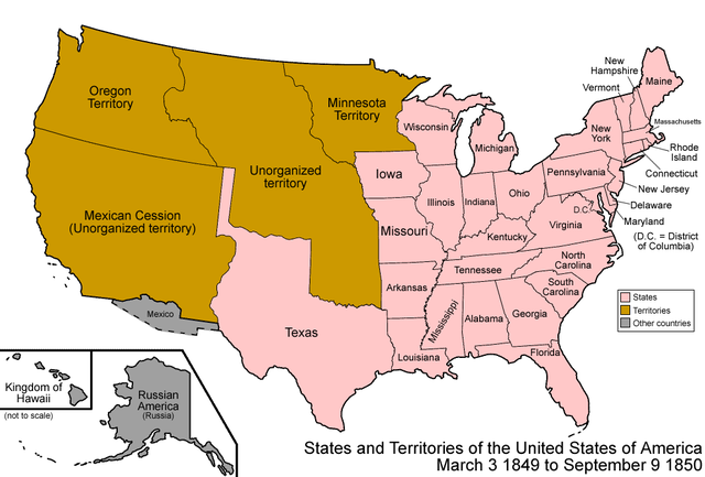
Map of the states and territories of the United States as it was from 1849 to 1850.
|
| Font | Treball propi |
| Autor | Made by User:Golbez. See Charles O. Paullin and John K. Wright's Atlas of the Historical Geography of the United States (1932) for PD maps which support these. |
| Permís (Com reutilitzar aquest fitxer) |
Own work, attribution required (Multi-license with GFDL and Creative Commons CC-BY 2.5) |

|
Aquesta imatge (de tipus mapa) s'hauria de tornar a crear utilitzant gràfics vectorials com ara un fitxer SVG. Això té diversos avantatges; en trobareu més informació a Commons:Media for cleanup. Si ja disposeu d'una versió d'aquesta imatge en format SVG, us preguem que la pengeu; després, reemplaceu aquesta plantilla amb la plantilla {{Vector version available|nom nou de la imatge.svg}} en aquesta imatge.
|
Llicència
Jo, el titular dels drets d'autor d'aquest treball, el public sota les següents llicències:

|
S'autoritza la còpia, la distribució i la modificació d'aquest document sota els termes de la llicència de documentació lliure GNU versió 1.2 o qualsevol altra versió posterior que publiqui la Free Software Foundation; sense seccions invariants, ni textos de portada, ni textos de contraportada. S'inclou una còpia d'aquesta llicència en la secció titulada GNU Free Documentation License. |
| Aquest fitxer està subjecte a la llicència de Creative Commons Reconeixement i Compartir Igual 3.0 No adaptada. | ||
| ||
| Aquest avís de llicència s'ha afegit a aquest fitxer d'acord amb l'actualització de la llicència GFDL. |
Aquest fitxer està disponible sota la llicència Creative Commons Reconeixement 2.5 Genèrica.
- Sou lliure de:
- compartir – copiar, distribuir i comunicar públicament l'obra
- adaptar – fer-ne obres derivades
- Amb les condicions següents:
- reconeixement – Heu de donar la informació adequada sobre l'autor, proporcionar un enllaç a la llicència i indicar si s'han realitzat canvis. Podeu fer-ho amb qualsevol mitjà raonable, però de cap manera no suggereixi que l'autor us dóna suport o aprova l'ús que en feu.
Podeu seleccionar la llicència que vulgueu.
| Territorial evolution maps of the United States |
| v · d (template shows date of beginning of change yyyy-mm-dd) |
| 1789-03, 1789-08, 1790-04, 1790-05, 1791-03, 1791-09, 1792-03, 1792-06, 1795, 1796, 1798, 1800-07-04, 1800-07, 1802, 1803-03, 1803-04, 1804-03, 1804-10, 1805-01, 1805-07, 1809, 1810-04, 1810-10, 1812-04, 1812-05, 1812-06, 1816, 1817-03, 1817-12, 1818-10, 1818-12, 1819-03, 1819-12, 1820, 1821-07, 1821, 1822, 1824, 1828, 1834, 1836-03, 1836-06, 1836-07, 1837-01, 1837-03, 1838, 1842, 1845-03, 1845-12, 1846-06, 1846-12, 1848-02, 1848-05, 1848-08, 1849, 1850, 1853-03, 1853-12, 1854, 1858, 1859, 1860, 1861-01, 1861-02-04, 1861-02-28, 1861-03, 1861-08, 1862, 1863-02, 1863-03, 1863-06, 1864-05, 1864-10, 1865, 1866, 1867-01, 1867-03, 1867-10, 1868, 1876, 1884, 1889-11-02, 1889-11-08, 1889-11-11, 1890-05, 1890-07-03, 1890-07-10, 1896-01, 1896-05, 1898, 1907, 1912-01, 1912-02, 1912-08, 1959-01, 1959-08 |
Historial del fitxer
Cliqueu una data/hora per veure el fitxer tal com era aleshores.
| Data/hora | Miniatura | Dimensions | Usuari/a | Comentari | |
|---|---|---|---|---|---|
| actual | 09:04, 29 jul 2006 | | 1.000 × 677 (95 Ko) | Golbez | {{Information| |Description=Map of the states and territories of the United States as it was from |Source= |Date= |Author=Made by User:Golbez. |Permission=Own work, attribution required (Multi-license with GFDL and Creative Commons CC-BY 2.5) |other_ |
Ús del fitxer
La pàgina següent utilitza aquest fitxer:
Ús global del fitxer
Utilització d'aquest fitxer en altres wikis:
- Utilització a ar.wikipedia.org
- Utilització a bg.wikipedia.org
- Utilització a cs.wikipedia.org
- Utilització a da.wikipedia.org
- Utilització a de.wikipedia.org
- Utilització a en.wikipedia.org
- James K. Polk
- Compromise of 1850
- Henry Clay
- Sam Houston
- Southwestern United States
- Talk:List of U.S. states by date of admission to the Union
- Presidency of James K. Polk
- Presidency of Millard Fillmore
- Zachary Taylor
- Stephen A. Douglas
- History of the United States foreign policy
- History of U.S. foreign policy, 1829–1861
- User:Falcaorib/Canada, United States and Mexico
- Utilització a es.wikipedia.org
- Utilització a fa.wikipedia.org
- Utilització a fr.wikipedia.org
- Utilització a he.wikipedia.org
- Utilització a hy.wikipedia.org
- Utilització a it.wikipedia.org
- Utilització a ja.wikipedia.org
- Utilització a nl.wikipedia.org
- Utilització a no.wikipedia.org
- Utilització a pt.wikipedia.org
- Utilització a ru.wikipedia.org
- Utilització a uk.wikipedia.org
- Utilització a vi.wikipedia.org
- Utilització a zh.wikipedia.org