
Fitxer:ValcourIslandMap1776Detail.jpg

Mida d'aquesta previsualització: 541 × 599 píxels. Altres resolucions: 217 × 240 píxels | 434 × 480 píxels | 803 × 889 píxels.
Fitxer original (803 × 889 píxels, mida del fitxer: 337 Ko, tipus MIME: image/jpeg)
| Aquest fitxer i la informació mostrada a continuació provenen del dipòsit multimèdia lliure Wikimedia Commons. |
Resum
| Descripció |
English:

|
||||||||||||||||||||||
| Data | |||||||||||||||||||||||
| Font |
From the Boston Public Library Digital Maps Collection (http://maps.bpl.org/). |
||||||||||||||||||||||
| Autor |
|
||||||||||||||||||||||
Llicència
|
Aquest material està en domini públic als Estats Units i als altres països on el dret d'autor s'estén per 100 anys (o menys) després de la mort de l'autor. | |
| Aquest fitxer està identificat com a lliure de restriccions conegudes sota la llei de drets d'autor, inclosos els drets veïns. | |
Historial del fitxer
Cliqueu una data/hora per veure el fitxer tal com era aleshores.
| Data/hora | Miniatura | Dimensions | Usuari/a | Comentari | |
|---|---|---|---|---|---|
| actual | 23:29, 17 feb 2009 | | 803 × 889 (337 Ko) | Magicpiano | Higher-res version. |
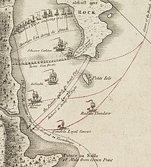
| 23:23, 17 feb 2009 |  | 189 × 214 (23 Ko) | Magicpiano | {{Information |Description={{en|1=thumb|right|source map showing area detailed in this image This is a blowup of the area highlighted in the map shown to the right, showing the detail of the action in the [[w:Bat |
Ús del fitxer
La pàgina següent utilitza aquest fitxer:
Ús global del fitxer
Utilització d'aquest fitxer en altres wikis:
- Utilització a de.wikipedia.org
- Utilització a en.wikipedia.org
- Utilització a es.wikipedia.org
- Utilització a fi.wikipedia.org
- Utilització a fr.wikipedia.org
- Utilització a it.wikipedia.org
- Utilització a ja.wikipedia.org
- Utilització a no.wikipedia.org
- Utilització a ru.wikipedia.org
- Utilització a simple.wikipedia.org
- Utilització a www.wikidata.org