
Fitxer:Virgin islands national park map.png
Mida d'aquesta previsualització: 800 × 493 píxels. Altres resolucions: 320 × 197 píxels | 640 × 394 píxels | 1.024 × 630 píxels | 1.629 × 1.003 píxels.
Fitxer original (1.629 × 1.003 píxels, mida del fitxer: 515 Ko, tipus MIME: image/png)
| Aquest fitxer i la informació mostrada a continuació provenen del dipòsit multimèdia lliure Wikimedia Commons. |
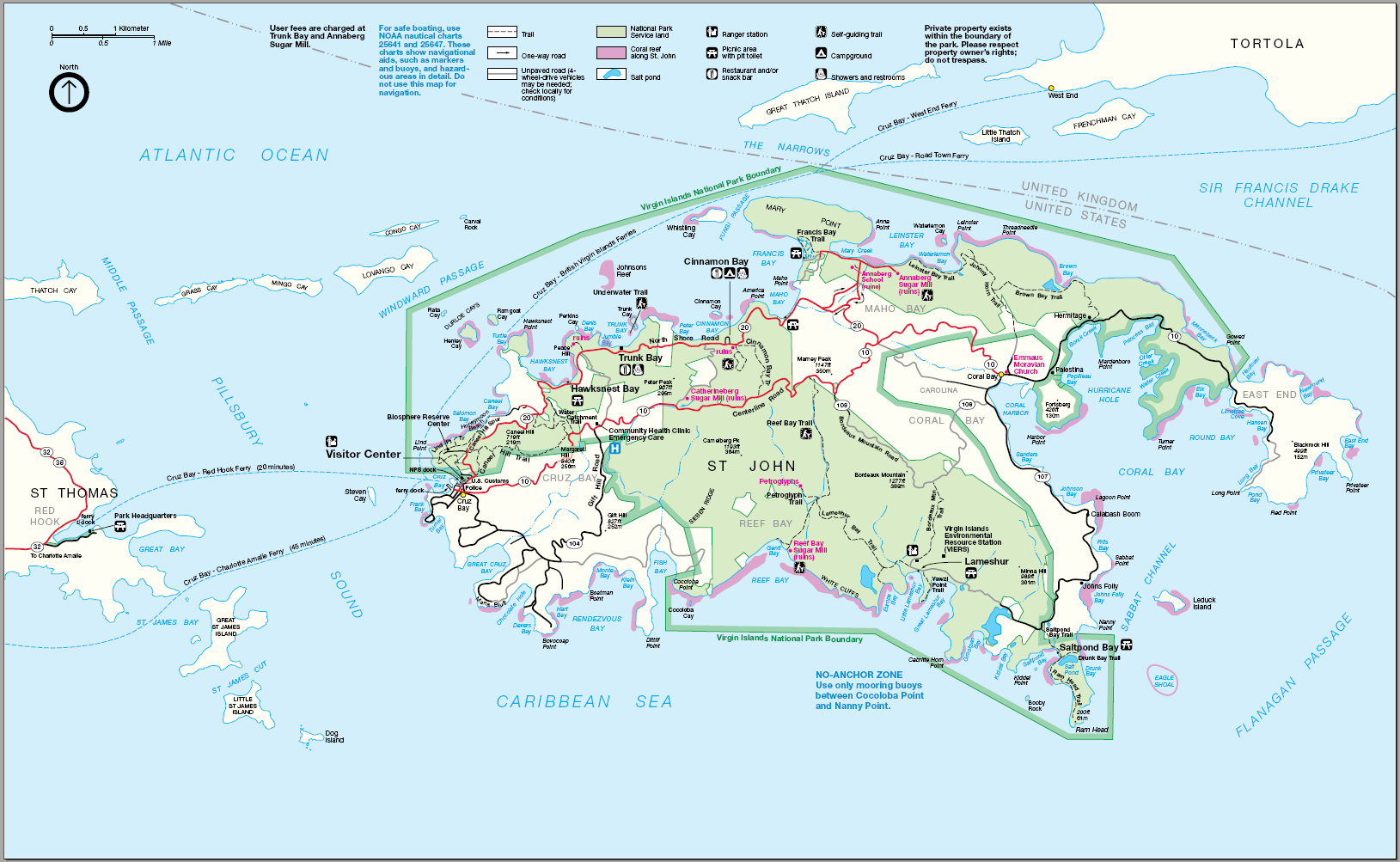
| Descripció | Map of Virgin Islands National Park — primarily on Saint John island, of the United States Virgin Islands. |
| Data | Data desconeguda |
| Font | http://www.nps.gov |
| Autor | Desconegut |
| Permís (Com reutilitzar aquest fitxer) |
PD |
| This image or media file contains material based on a work of a National Park Service employee, created as part of that person's official duties. As a work of the U.S. federal government, such work is in the public domain in the United States. See the NPS website and NPS copyright policy for more information. |
Historial del fitxer
Cliqueu una data/hora per veure el fitxer tal com era aleshores.
| Data/hora | Miniatura | Dimensions | Usuari/a | Comentari | |
|---|---|---|---|---|---|
| actual | 22:58, 21 maig 2006 | | 1.629 × 1.003 (515 Ko) | Huebi~commonswiki | {{Information| |Description=Map of Virgin Islands National Park |Source=http://www.nps.gov |Date=?? |Author=?? |Permission=PD |other_versions=?? }} ((PD-USGov-NPS}} |
Ús del fitxer
La pàgina següent utilitza aquest fitxer:
Ús global del fitxer
Utilització d'aquest fitxer en altres wikis:
- Utilització a ar.wikipedia.org
- Utilització a bg.wikipedia.org
- Utilització a de.wikipedia.org
- Utilització a en.wikipedia.org
- Utilització a fr.wikipedia.org
- Utilització a nl.wikipedia.org
- Utilització a no.wikipedia.org
- Utilització a pl.wikipedia.org
- Utilització a ru.wikipedia.org
- Utilització a sv.wikipedia.org
- Utilització a tr.wikipedia.org
- Utilització a uk.wikipedia.org
- Utilització a vi.wikipedia.org
- Utilització a www.wikidata.org