
Fitxer:Winchester cathedral - geograph.org.uk - 1628919.jpg
No hi ha cap versió amb una resolució més gran.
Winchester_cathedral_-_geograph.org.uk_-_1628919.jpg (640 × 428 píxels, mida del fitxer: 188 Ko, tipus MIME: image/jpeg)
| Aquest fitxer i la informació mostrada a continuació provenen del dipòsit multimèdia lliure Wikimedia Commons. |
Resum
| Descripció |
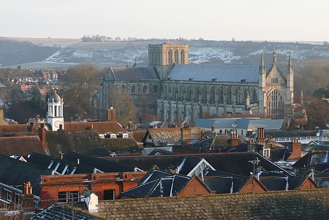
English: Winchester cathedral Taken from the 2nd floor of Hampshire County Council's refurbished offices at E2 Court. The cathedral squats in the valley of the River Itchen, but none the less dominates the city. Started in 1079 by Bishop Walklin, it was consecrated in 1093. The tower fell down in 1107 (thought to be bad luck caused by the burial of the unpopular King William 2nd (Rufus) here in 1100) and was never rebuilt. The nave (this end between the West window and the tower) is the second longest in Europe after St. Peter's in Rome. |
| Data | |
| Font | From geograph.org.uk |
| Autor | Graham Horn |
| Reconeixement (required by the license) | Graham Horn / Winchester cathedral / |
| Posició de la càmera | | Aquesta i altres imatges properes a: OpenStreetMap |
|---|
_heading:135.00&language=ca)
| Posició de l'objecte | | Aquesta i altres imatges properes a: OpenStreetMap |
|---|
_heading:135.00&language=ca)
Llicència

|
Aquesta imatge prové de la col·lecció del projecte Geograph British Isles. Vegeu la pàgina d'aquesta fotografia al lloc web Geograph per a més informació del fotògraf. El titular dels drets d'autor d'aquesta imatge és Graham Horn i autoritza utilitzar-la sota la llicència Reconeixement-CompartirIgual 2.0 de Creative Commons.
|
Aquest fitxer està publicat sota la llicència de Creative Commons Reconeixement i Compartir Igual 2.0 Genèrica.
Reconeixement: Graham Horn
- Sou lliure de:
- compartir – copiar, distribuir i comunicar públicament l'obra
- adaptar – fer-ne obres derivades
- Amb les condicions següents:
- reconeixement – Heu de donar la informació adequada sobre l'autor, proporcionar un enllaç a la llicència i indicar si s'han realitzat canvis. Podeu fer-ho amb qualsevol mitjà raonable, però de cap manera no suggereixi que l'autor us dóna suport o aprova l'ús que en feu.
- compartir igual – Si modifiqueu, transformeu, o generareu amb el material, haureu de distribuir les vostres contribucions sota una llicència similar o una de compatible com l'original
Historial del fitxer
Cliqueu una data/hora per veure el fitxer tal com era aleshores.
| Data/hora | Miniatura | Dimensions | Usuari/a | Comentari | |
|---|---|---|---|---|---|
| actual | 16:55, 4 març 2011 | | 640 × 428 (188 Ko) | GeographBot | == {{int:filedesc}} == {{Information |description={{en|1=Winchester cathedral Taken from the 2nd floor of Hampshire County Council's refurbished offices at E2 Court. The cathedral squats in the valley of the River Itchen, but none the less dominates the |
Ús del fitxer
No hi ha pàgines que utilitzin aquest fitxer.
Ús global del fitxer
Utilització d'aquest fitxer en altres wikis:
- Utilització a ang.wikipedia.org
- Utilització a az.wikipedia.org
- Utilització a en.wikipedia.org
- Utilització a fi.wikipedia.org
- Utilització a is.wikipedia.org
- Utilització a lv.wikipedia.org
- Utilització a vi.wikipedia.org
- Utilització a war.wikipedia.org
- Utilització a wuu.wikipedia.org
- Utilització a zh-min-nan.wikipedia.org