
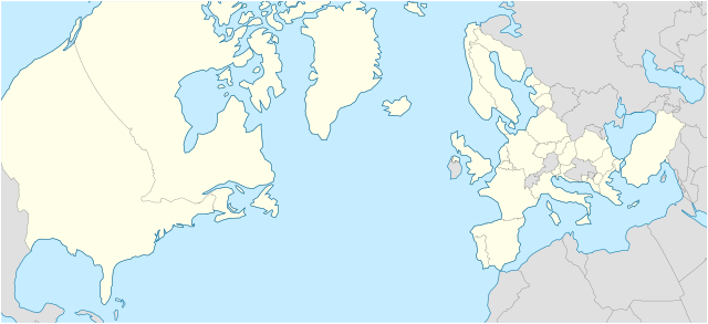
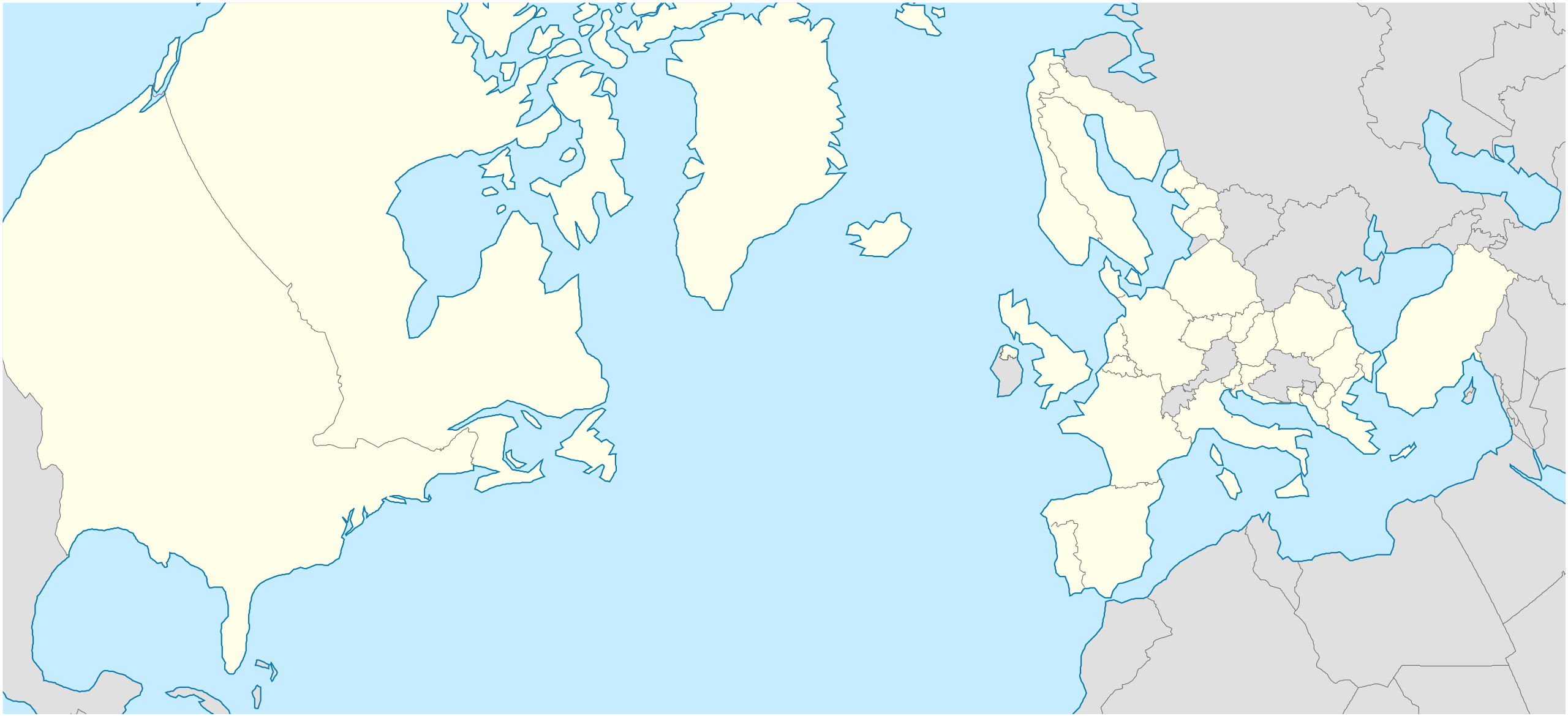
Fitxer:NATO Territory Map.svg

Mida d'aquesta previsualització PNG del fitxer SVG: 709 × 324 píxels. Altres resolucions: 320 × 146 píxels | 640 × 292 píxels | 1.024 × 468 píxels | 1.280 × 585 píxels | 2.560 × 1.170 píxels.
Fitxer original (fitxer SVG, nominalment 709 × 324 píxels, mida del fitxer: 480 Ko)
| Aquest fitxer i la informació mostrada a continuació provenen del dipòsit multimèdia lliure Wikimedia Commons. |
Resum
| Descripció |
English: A geographical projection of a map that highlights all member nations of the North Atlantic Treaty Organization (NATO).
Nederlands: Een geografische projectie waarin het gebied van alle lidstaten van de Noord-Atlantische Verdrags Organisatie (NAVO) wordt belicht. |
| Data | |
| Font | Treball propi - inspired by the work of Ssolbergj in File:NATO laea location map.svg. |
| Autor | Woudsma |
| SVG genesis | Aquesta imatge vectorial ha estat creada amb Inkscape. |
Llicència
Jo, el titular dels drets d'autor d'aquest treball, el public sota la següent llicència:
This file is licensed under the Creative Commons Attribution-Share Alike 4.0 International license.
- Sou lliure de:
- compartir – copiar, distribuir i comunicar públicament l'obra
- adaptar – fer-ne obres derivades
- Amb les condicions següents:
- reconeixement – Heu de donar la informació adequada sobre l'autor, proporcionar un enllaç a la llicència i indicar si s'han realitzat canvis. Podeu fer-ho amb qualsevol mitjà raonable, però de cap manera no suggereixi que l'autor us dóna suport o aprova l'ús que en feu.
- compartir igual – Si modifiqueu, transformeu, o generareu amb el material, haureu de distribuir les vostres contribucions sota una llicència similar o una de compatible com l'original
Historial del fitxer
Cliqueu una data/hora per veure el fitxer tal com era aleshores.
| Data/hora | Miniatura | Dimensions | Usuari/a | Comentari | |
|---|---|---|---|---|---|
| actual | 05:07, 9 març 2024 | | 709 × 324 (480 Ko) | Woudsma | Uploaded own work with UploadWizard |
Ús del fitxer
No hi ha pàgines que utilitzin aquest fitxer.
Ús global del fitxer
Utilització d'aquest fitxer en altres wikis:
- Utilització a en.wikipedia.org
- NATO
- Incirlik Air Base
- Allied Command Operations
- Allied Command Transformation
- Joint Warfare Centre
- Template:Location map
- Template:Location map/doc
- NATO School
- Joint Force Training Centre
- Mürted Airfield Command
- Joint Analysis and Lessons Learned Centre
- Template:Location map/sandbox
- Çiğli Air Base
- Ankara Güvercinlik Army Air Base
- Etimesgut Air Base
- Cengiz Topel Naval Air Station
- Kütahya Air Base
- Allied Land Command
- Allied Maritime Command
- Naval Striking and Support Forces NATO
- Template:NATO commands
- Module:Location map/data/NATO
- Module:Location map/data/NATO/doc
- European Union–NATO relations
- User:Mgkrupa/Code and Symbols
- User:Woudsma/NATO Commands Map