
Fitxer:British kingdoms c 800.png
Mida d'aquesta previsualització: 454 × 599 píxels. Altres resolucions: 182 × 240 píxels | 364 × 480 píxels | 1.000 × 1.320 píxels.
Fitxer original (1.000 × 1.320 píxels, mida del fitxer: 1,59 Mo, tipus MIME: image/png)
| Aquest fitxer i la informació mostrada a continuació provenen del dipòsit multimèdia lliure Wikimedia Commons. |
Resum
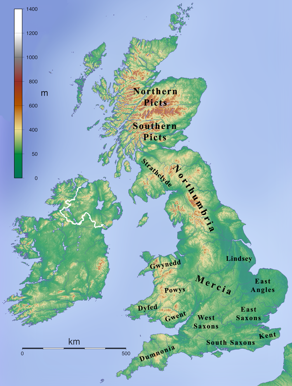
| Descripció | Map depicting the British Isles during the 7th century. |
| Data | |
| Font | Own work created by combining File:Topographic Map of the UK - Blank.png and en:File:British 7C kingdoms with Bernicia and Deira.gif and removing the Bernicia and Deira labels. |
| Autor | Kmusser |
Llicència
Jo, el titular dels drets d'autor d'aquest treball, el public sota la següent llicència:
Aquest fitxer està subjecte a la llicència de Creative Commons Reconeixement i Compartir Igual 3.0 No adaptada.
- Sou lliure de:
- compartir – copiar, distribuir i comunicar públicament l'obra
- adaptar – fer-ne obres derivades
- Amb les condicions següents:
- reconeixement – Heu de donar la informació adequada sobre l'autor, proporcionar un enllaç a la llicència i indicar si s'han realitzat canvis. Podeu fer-ho amb qualsevol mitjà raonable, però de cap manera no suggereixi que l'autor us dóna suport o aprova l'ús que en feu.
- compartir igual – Si modifiqueu, transformeu, o generareu amb el material, haureu de distribuir les vostres contribucions sota una llicència similar o una de compatible com l'original
Historial del fitxer
Cliqueu una data/hora per veure el fitxer tal com era aleshores.
| Data/hora | Miniatura | Dimensions | Usuari/a | Comentari | |
|---|---|---|---|---|---|
| actual | 15:24, 12 gen 2009 | | 1.000 × 1.320 (1,59 Mo) | Kmusser | == Summary == {{Information |Description=Map depicting the British Islands during the 7th century. |Source=Own work created by combining File:Topographic Map of the UK - Blank.png and en:File:British 7C kingdoms with Bernicia and Deira.gif and r |
Ús del fitxer
La pàgina següent utilitza aquest fitxer:
Ús global del fitxer
Utilització d'aquest fitxer en altres wikis:
- Utilització a arz.wikipedia.org
- Utilització a de.wikipedia.org
- Utilització a en.wikipedia.org
- Utilització a es.wikipedia.org
- Utilització a gl.wikipedia.org
- Utilització a got.wikipedia.org
- Utilització a id.wikipedia.org
- Utilització a it.wikipedia.org