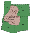
Fitxer:Colorado Plateaus map.png
Aparença
Colorado_Plateaus_map.png (324 × 353 píxels, mida del fitxer: 18 Ko, tipus MIME: image/png)
Historial del fitxer
Cliqueu una data/hora per veure el fitxer tal com era aleshores.
| Data/hora | Miniatura | Dimensions | Usuari/a | Comentari | |
|---|---|---|---|---|---|
| actual | 11:50, 17 maig 2010 |  | 324 × 353 (18 Ko) | Mario1952 | {{Information |Description={{en|1=added missing section}} |Source=NPS |Author=NPS |Date= |Permission= |other_versions= }} |
| 17:08, 23 feb 2005 |  | 324 × 353 (16 Ko) | Complex01 |
Ús del fitxer
La pàgina següent utilitza aquest fitxer:
Ús global del fitxer
Utilització d'aquest fitxer en altres wikis:
- Utilització a bg.wikipedia.org
- Utilització a cs.wikipedia.org
- Utilització a de.wikipedia.org
- Utilització a en.wikipedia.org
- Utilització a eo.wikipedia.org
- Utilització a es.wikipedia.org
- Utilització a et.wikipedia.org
- Utilització a eu.wikipedia.org
- Utilització a fa.wikipedia.org
- Utilització a fi.wikipedia.org
- Utilització a fr.wikipedia.org
- Utilització a he.wikipedia.org
- Utilització a id.wikipedia.org
- Utilització a is.wikipedia.org
- Utilització a it.wikipedia.org
- Utilització a ja.wikipedia.org
- Utilització a kab.wikipedia.org
- Utilització a kn.wikipedia.org
- Utilització a ko.wikipedia.org
- Utilització a lb.wikipedia.org
- Utilització a lt.wikipedia.org
- Utilització a nl.wikipedia.org
- Utilització a pl.wikipedia.org
- Utilització a pt.wikipedia.org
- Utilització a trv.wikipedia.org
- Utilització a tr.wikipedia.org
- Utilització a uk.wikipedia.org
- Utilització a uz.wikipedia.org
- Utilització a www.wikidata.org
- Utilització a zh.wikipedia.org


