
Fitxer:Everest-3D-Map-Type-EN.jpg

Mida d'aquesta previsualització: 800 × 600 píxels. Altres resolucions: 320 × 240 píxels | 640 × 480 píxels | 1.024 × 768 píxels | 1.280 × 960 píxels | 2.560 × 1.920 píxels | 5.000 × 3.750 píxels.
Fitxer original (5.000 × 3.750 píxels, mida del fitxer: 4,28 Mo, tipus MIME: image/jpeg)
| Aquest fitxer i la informació mostrada a continuació provenen del dipòsit multimèdia lliure Wikimedia Commons. |
Resum
| Descripció |
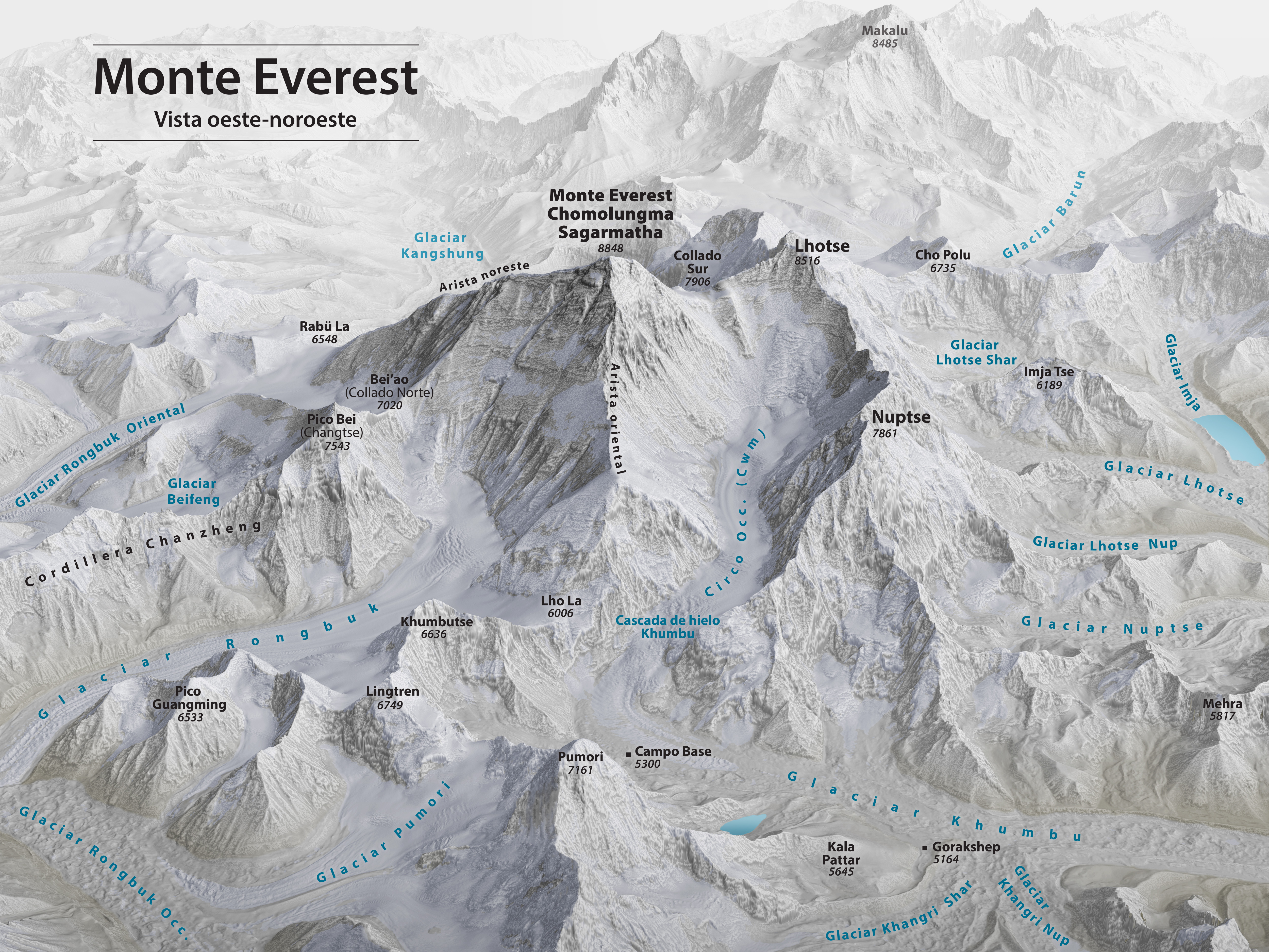
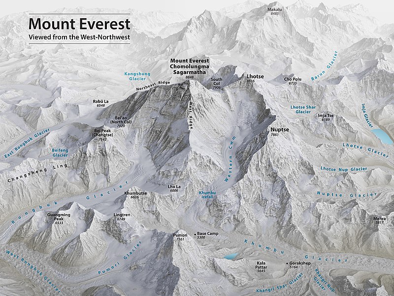
English: Mount Everest 3D Map by Tom Patterson, with English annotation, based on data from the US National Snow and Ice Data Center and Landsat 8. |
||
| Data | |||
| Font | http://shadedrelief.com/Everest-3D-Map | ||
| Autor | Tom Patterson | ||
| Altres versions |
|

Assessment
|

Llicència
| L'ús d'aquest fitxer és regulat sota les condicions de Creative Commons de CC0 1.0 lliurament al domini públic universal. | |
| La persona que ha associat un treball amb aquest document ha dedicat l'obra domini públic, renunciant en tot el món a tots els seus drets de d'autor i a tots els drets legals relacionats que tenia en l'obra, en la mesura permesa per la llei. Podeu copiar, modificar, distribuir i modificar l'obra, fins i tot amb fins comercials, tot sense demanar permís.
|
License note: Source page at this link archived here states: "Terms of Use - The maps on this page are in the public domain. You may use them any way you like, including modifying the content, digital and print reproduction, and selling them for profit. Consider these maps as yours."
Historial del fitxer
Cliqueu una data/hora per veure el fitxer tal com era aleshores.
| Data/hora | Miniatura | Dimensions | Usuari/a | Comentari | |
|---|---|---|---|---|---|
| actual | 02:53, 19 nov 2020 | | 5.000 × 3.750 (4,28 Mo) | Cmglee | Uploaded a work by Tom Patterson from http://shadedrelief.com/Everest-3D-Map with UploadWizard |
Ús del fitxer
Les 3 pàgines següents utilitzen aquest fitxer:
Ús global del fitxer
Utilització d'aquest fitxer en altres wikis:
- Utilització a bs.wikipedia.org
- Utilització a ckb.wikipedia.org
- Utilització a en.wikipedia.org
- Mount Everest
- Timeline of Mount Everest expeditions
- Wikipedia:WikiProject Nepal
- Portal:Nepal
- Wikipedia:WikiProject China/Featured and good content
- User:Cmglee
- Wikipedia:Featured pictures/Diagrams, drawings, and maps/Maps
- Traverse (climbing)
- Wikipedia:WikiProject Geology/Recognized content
- 1953 British Mount Everest expedition
- Wikipedia:WikiProject Geology/Automated list of recognized content
- Talk:Mount Everest/Archive 6
- Portal:Nepal/Recognized content
- Portal:Sports/Recognized content
- Wikipedia:WikiProject Nepal/Recognized content
- Wikipedia:Featured pictures thumbs/69
- Wikipedia:Featured picture candidates/November-2020
- Wikipedia:Featured picture candidates/Mount Everest 3D map
- Wikipedia:Wikipedia Signpost/2020-12-28/Featured content
- Wikipedia:Wikipedia Signpost/Single/2020-12-28
- User:Evad37/Wikipedia:Wikipedia Signpost/Single/2020-12-28
- User talk:Cmglee/archive2020
- Wikipedia:WikiProject Mountains/Recognized content
- Wikipedia:Picture of the day/May 2023
- Template:POTD/2023-05-29
- Wikipedia:Main Page history/2023 May 29
- Wikipedia:Main Page history/2023 May 29b
- Utilització a ext.wikipedia.org
- Utilització a fi.wikipedia.org
- Utilització a fr.wikipedia.org
- Utilització a id.wikipedia.org
- Utilització a nl.wikipedia.org
- Utilització a sh.wikipedia.org