
Fitxer:Gz-map.gif
No hi ha cap versió amb una resolució més gran.
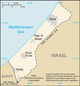
Gz-map.gif (330 × 354 píxels, mida del fitxer: 14 Ko, tipus MIME: image/gif)
| Aquest fitxer i la informació mostrada a continuació provenen del dipòsit multimèdia lliure Wikimedia Commons. |
Updated version of previous file, copied from the CIA World Factbook from this page:
- https://www.cia.gov/library/publications/the-world-factbook/geos/gz.html archive copy at the Wayback Machine
This image is in the public domain because it contains materials that originally came from the United States Central Intelligence Agency's World Factbook.
|
 |
derivative works
Derivative works of this file: Gaza Strip 2011-01-20.gif
Historial del fitxer
Cliqueu una data/hora per veure el fitxer tal com era aleshores.
| Data/hora | Miniatura | Dimensions | Usuari/a | Comentari | |
|---|---|---|---|---|---|
| actual | 16:18, 27 gen 2008 | | 330 × 354 (14 Ko) | Timeshifter | Taken from CIA.gov map page for Gaza Strip: "This page was last updated on 24 January, 2008" |
| 03:58, 27 gen 2008 |  | 330 × 354 (13 Ko) | Koavf | Removed inaccurate notice about Israeli occupation. | |
| 16:08, 2 des 2007 |  | 330 × 354 (14 Ko) | Timeshifter | Nov. 15 2007 update of CIA.gov map page for Gaza Strip. | |
| 20:09, 15 ago 2005 |  | 328 × 352 (9 Ko) | Mrmiscellanious~commonswiki | Updated version of previous file, copied from CIA World Factbook on August 15, 2005. |
Ús del fitxer
La pàgina següent utilitza aquest fitxer:
Ús global del fitxer
Utilització d'aquest fitxer en altres wikis:
- Utilització a ang.wikipedia.org
- Utilització a ar.wikipedia.org
- Utilització a arz.wikipedia.org
- Utilització a ast.wikipedia.org
- Utilització a ba.wikipedia.org
- Utilització a diq.wikipedia.org
- Utilització a el.wikipedia.org
- Utilització a en.wikinews.org
- Utilització a eo.wikipedia.org
- Utilització a eu.wikipedia.org
- Utilització a fi.wikipedia.org
- Utilització a ga.wikipedia.org
- Utilització a gl.wikipedia.org
- Utilització a hu.wikipedia.org
- Utilització a ku.wikipedia.org
- Utilització a la.wikipedia.org
- Utilització a mt.wikipedia.org
- Utilització a pt.wikinews.org
- Utilització a ro.wikipedia.org
- Utilització a sl.wikipedia.org
- Utilització a sv.wikipedia.org
- Utilització a ta.wikipedia.org
- Utilització a tr.wikinews.org
- Utilització a tt.wikipedia.org
- Utilització a uk.wikipedia.org
- Utilització a ur.wikipedia.org
- Utilització a vi.wikipedia.org
- Utilització a www.wikidata.org