
Fitxer:Leigh Smith 1880 expedition map.tif
Fitxer original (4.275 × 3.657 píxels, mida del fitxer: 15,04 Mo, tipus MIME: image/tiff)
| Aquest fitxer i la informació mostrada a continuació provenen del dipòsit multimèdia lliure Wikimedia Commons. |
Resum
| Descripció |
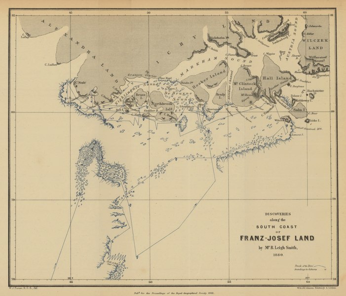
English: Route, direction, and dates of voyage are shown.
Ice sheets and icebergs along route shown in blue. Depth shown by soundings. Relief shown by hachures. Conjectural coastlines shown by broken lines. Site of abandonment of Tegetthoff [Austrian vessel] in 1874 is shown. Scale: ca. 1 : 9 200 000 From: Proceedings of the Royal Geographical Society and monthly record of geography. Vol. 3 (1881), no. 3, pp. 129-50 |
| Data | |
| Font | Maps and Geospatial Data, Princeton University Library |
| Autor | William John Turner |
Llicència
|
Aquest material està en domini públic als Estats Units i als altres països on el dret d'autor s'estén per 70 anys (o menys) després de la mort de l'autor. Aquesta obra es troba en el domini públic als Estats Units d'Amèrica per haver estat publicada abans de l'1 de gener de 1929. | |
| Aquest fitxer està identificat com a lliure de restriccions conegudes sota la llei de drets d'autor, inclosos els drets veïns. | |
Historial del fitxer
Cliqueu una data/hora per veure el fitxer tal com era aleshores.
| Data/hora | Miniatura | Dimensions | Usuari/a | Comentari | |
|---|---|---|---|---|---|
| actual | 02:33, 11 gen 2021 |  | 4.275 × 3.657 (15,04 Mo) | Kaschelott | Uploaded a work by William John Turner from https://maps.princeton.edu/catalog/princeton-02870z378 with UploadWizard |
Ús del fitxer
Les 2 pàgines següents utilitzen aquest fitxer:
Ús global del fitxer
Utilització d'aquest fitxer en altres wikis:
- Utilització a en.wikipedia.org
- Utilització a es.wikipedia.org
- Utilització a ru.wikipedia.org
- Utilització a sv.wikipedia.org