
Fitxer:MANCHURIA-U.S.S.R BOUNDARY Ct002999.jpg
Mida d'aquesta previsualització: 784 × 599 píxels. Altres resolucions: 314 × 240 píxels | 628 × 480 píxels | 1.005 × 768 píxels | 1.280 × 978 píxels | 2.560 × 1.957 píxels | 4.167 × 3.185 píxels.
Fitxer original (4.167 × 3.185 píxels, mida del fitxer: 4,25 Mo, tipus MIME: image/jpeg)
| Aquest fitxer i la informació mostrada a continuació provenen del dipòsit multimèdia lliure Wikimedia Commons. |
Resum
| Descripció |
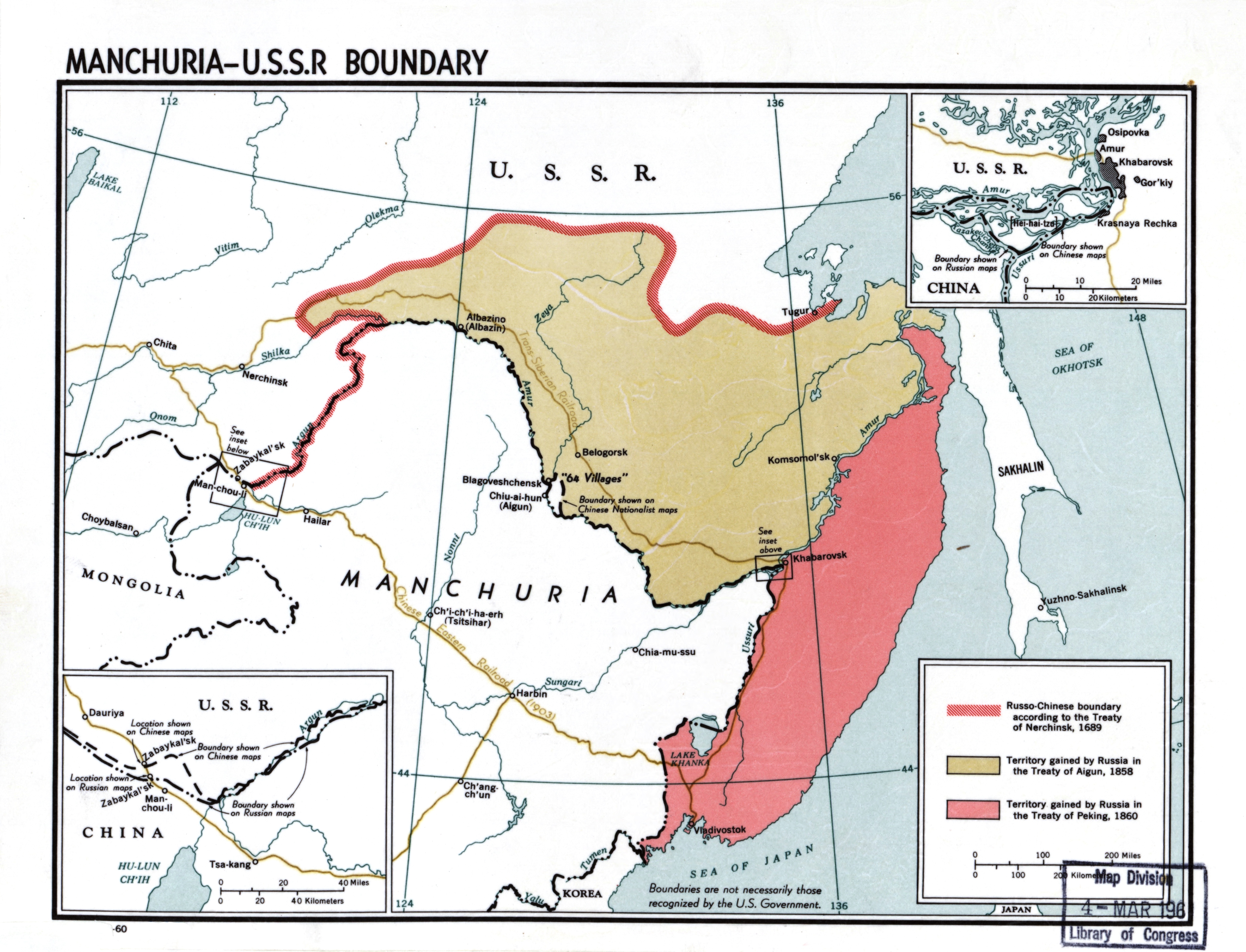
English: Manchuria-U.S.S.R. boundary |
| Data | |
| Font |
Library of Congress Geography and Map Division Washington, D.C. 20540-4650 USA DIGITAL ID g7822m ct002999 http://hdl.loc.gov/loc.gmd/g7822m.ct002999 |
| Autor | CIA |
Llicència
| This image is a work of a Central Intelligence Agency employee, taken or made as part of that person's official duties. As a Work of the United States Government, this image or media is in the public domain in the United States.
|

|
Historial del fitxer
Cliqueu una data/hora per veure el fitxer tal com era aleshores.
| Data/hora | Miniatura | Dimensions | Usuari/a | Comentari | |
|---|---|---|---|---|---|
| actual | 22:50, 23 nov 2020 | | 4.167 × 3.185 (4,25 Mo) | Gryffindor | {{Information |Description= |Source= |Date= |Author= |Permission= |other_versions= }} |
| 16:53, 22 feb 2014 |  | 4.167 × 3.185 (6,22 Mo) | Viktoria Kunst | User created page with UploadWizard |
Ús del fitxer
La pàgina següent utilitza aquest fitxer:
Ús global del fitxer
Utilització d'aquest fitxer en altres wikis:
- Utilització a af.wikipedia.org
- Utilització a ar.wikipedia.org
- Utilització a az.wikipedia.org
- Utilització a bn.wikipedia.org
- Utilització a ckb.wikipedia.org
- Utilització a cs.wikipedia.org
- Utilització a da.wikipedia.org
- Utilització a de.wikipedia.org
- Utilització a en.wikipedia.org
- Manchuria
- History of Manchuria
- Treaty of Aigun
- Treaty of Nerchinsk
- Outer Manchuria
- Territorial evolution of Russia
- Sixty-Four Villages East of the River
- Bolshoy Ussuriysky Island
- Sino-Russian border conflicts
- Amur Annexation
- China–Russia relations
- China–Russia border
- Russia in the Opium Wars
- Timeline of the Qing dynasty
- Soviet deportations of Chinese people
- User:HNlander/Deportation of Chinese in the Soviet Union
- User:Falcaorib/China
- Utilització a en.wiktionary.org
- Utilització a es.wikipedia.org
- Utilització a fa.wikipedia.org
- Utilització a fi.wikipedia.org
- Utilització a fr.wikipedia.org
Vegeu més usos globals d'aquest fitxer.