
Fitxer:NPS lake-clark-map.pdf
Mida d'aquesta previsualització JPG del fitxer PDF: 690 × 600 píxels. Altres resolucions: 276 × 240 píxels | 552 × 480 píxels | 883 × 768 píxels | 1.178 × 1.024 píxels | 2.527 × 2.197 píxels.
Fitxer original (2.527 × 2.197 píxels, mida del fitxer: 17,71 Mo, tipus MIME: application/pdf)
| Aquest fitxer i la informació mostrada a continuació provenen del dipòsit multimèdia lliure Wikimedia Commons. |
Resum
| Descripció |
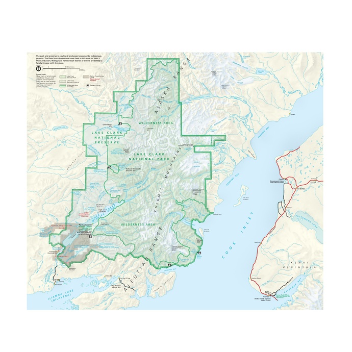
English: Lake Clark map from the official brochure, showing Redoubt Volcano, Dick Proenneke’s cabin, and the entire park and preserve. |
| Data | |
| Font | U.S. National Park Service (http://npmaps.com/wp-content/uploads/lake-clark-map.pdf) |
| Autor | U.S. National Park Service, restoration/cleanup by Matt Holly |
| Altres versions |
 |
Llicència
| This image or media file contains material based on a work of a National Park Service employee, created as part of that person's official duties. As a work of the U.S. federal government, such work is in the public domain in the United States. See the NPS website and NPS copyright policy for more information. |
Historial del fitxer
Cliqueu una data/hora per veure el fitxer tal com era aleshores.
| Data/hora | Miniatura | Dimensions | Usuari/a | Comentari | |
|---|---|---|---|---|---|
| actual | 02:39, 17 maig 2017 |  | 2.527 × 2.197 (17,71 Mo) | RKBot | =={{int:filedesc}}== {{Information |description= {{en|1=Lake Clark map from the official brochure, showing Redoubt Volcano, Dick Proenneke’s cabin, and the entire park and preserve.}} |date= 2016-04-10 |source= U.S. National Park Service (http://npma... |
Ús del fitxer
La pàgina següent utilitza aquest fitxer:
Ús global del fitxer
Utilització d'aquest fitxer en altres wikis:
- Utilització a arz.wikipedia.org
- Utilització a ceb.wikipedia.org
- Utilització a cs.wikipedia.org
- Utilització a en.wikipedia.org
- Utilització a fr.wikipedia.org
- Utilització a he.wikipedia.org
- Utilització a lld.wikipedia.org
- Utilització a www.wikidata.org