
Fitxer:Polynesian triangle.svg

Mida d'aquesta previsualització PNG del fitxer SVG: 600 × 600 píxels. Altres resolucions: 240 × 240 píxels | 480 × 480 píxels | 768 × 768 píxels | 1.024 × 1.024 píxels | 2.048 × 2.048 píxels.
Fitxer original (fitxer SVG, nominalment 600 × 600 píxels, mida del fitxer: 281 Ko)
| Aquest fitxer i la informació mostrada a continuació provenen del dipòsit multimèdia lliure Wikimedia Commons. |
Resum
| Descripció |
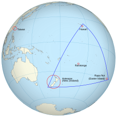
English: An orthographic projection of the pacific ocean, showing land outlines (resolution ~0.5 degrees) and the Polynesian triangle between Hawai'i, Rapa Nui and Aotearoa. Created using perlshaper to convert Natural Earth Data into an SVG file. Some tweaking was then done in Inkscape to fix up boundaries for countries on the edge of the projection. |
| Data | |
| Font | Treball propi |
| Autor | Gringer |
| Altres versions | Macedonian version |
| SVG genesis | Aquesta imatge vectorial ha estat creada amb Inkscape |
Llicència
Jo, el titular dels drets d'autor d'aquest treball, el public sota la següent llicència:
Aquest fitxer està subjecte a la llicència de Creative Commons Reconeixement 3.0 No adaptada.
- Sou lliure de:
- compartir – copiar, distribuir i comunicar públicament l'obra
- adaptar – fer-ne obres derivades
- Amb les condicions següents:
- reconeixement – Heu de donar la informació adequada sobre l'autor, proporcionar un enllaç a la llicència i indicar si s'han realitzat canvis. Podeu fer-ho amb qualsevol mitjà raonable, però de cap manera no suggereixi que l'autor us dóna suport o aprova l'ús que en feu.
Historial del fitxer
Cliqueu una data/hora per veure el fitxer tal com era aleshores.
| Data/hora | Miniatura | Dimensions | Usuari/a | Comentari | |
|---|---|---|---|---|---|
| actual | 04:36, 16 juny 2013 | | 600 × 600 (281 Ko) | AnonMoos | adjust margins |
| 13:34, 3 set 2010 |  | 550 × 550 (290 Ko) | Gringer | updated with [http://www.naturalearthdata.com Natural Earth Data] | |
| 05:01, 24 nov 2009 |  | 542 × 542 (90 Ko) | Gringer | {{Information |Description={{en|1=An orthographic projection of the pacific ocean, showing land outlines (resolution ~0.5 degrees) and the Polynesian triangle between Hawai'i, Rapa Nui and Aotearoa. Created using a custom perl script (http://user.interfac |
Ús del fitxer
La pàgina següent utilitza aquest fitxer:
Ús global del fitxer
Utilització d'aquest fitxer en altres wikis:
- Utilització a af.wikipedia.org
- Utilització a en.wikipedia.org
- Utilització a es.wikipedia.org
- Utilització a fi.wiktionary.org
- Utilització a fr.wikipedia.org
- Utilització a hi.wikipedia.org
- Utilització a ia.wikipedia.org
- Utilització a la.wikipedia.org
- Utilització a pl.wikipedia.org
- Utilització a pt.wiktionary.org
- Utilització a ru.wikipedia.org
- Utilització a sr.wikipedia.org
- Utilització a uk.wikipedia.org
- Utilització a www.wikidata.org