
Fitxer:Ramusio & Gastaldi Universale della Parti della Mondo 1556 UTA.jpg

Mida d'aquesta previsualització: 750 × 600 píxels. Altres resolucions: 300 × 240 píxels | 601 × 480 píxels | 961 × 768 píxels | 1.280 × 1.023 píxels | 2.560 × 2.046 píxels | 2.881 × 2.303 píxels.
Fitxer original (2.881 × 2.303 píxels, mida del fitxer: 3,85 Mo, tipus MIME: image/jpeg)
| Aquest fitxer i la informació mostrada a continuació provenen del dipòsit multimèdia lliure Wikimedia Commons. |
Resum
| Títol |
Italiano: Universale della Parte del Mondo Novamente Ritrovata English: General Map of the Newly Discovered Part of the World |
|||||||||||||||||||||||||||||||||||||||
| Descripció |
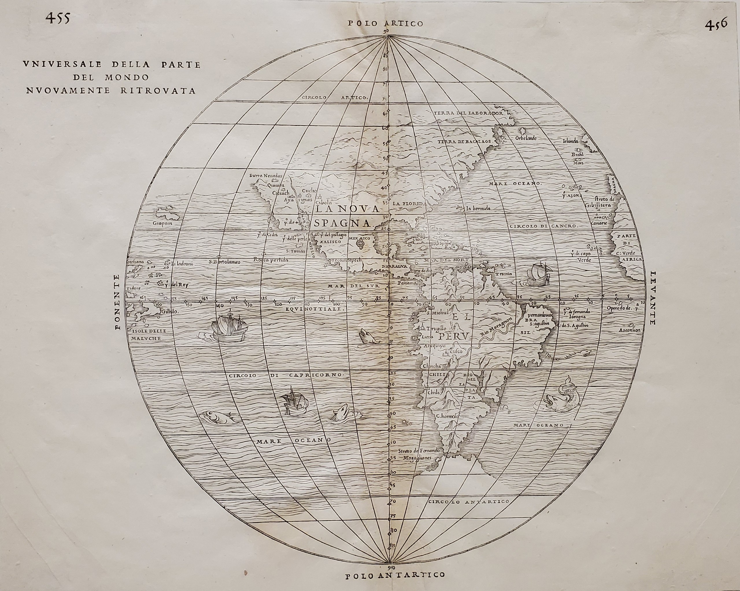
English: This Italian hemispherical view of the New World was the first printed map to include place names from Francisco Vásquez de Coronado's expedition of 1540-1542, the first major Spanish exploration or Entrada into what became New Spain's northwestern territories. The map lists the names of some of the rumored seven cities of gold that were actually the pueblos of present Arizona and New Mexico. Coronado's "Cibola" appears to be Hawikuh, a Zuni ruin in what is today far western New Mexico. On this map "Quivira" appears to its northwest, rather than to the northeast, in present Kansas, where Coronado’s account located it. Also mentioned is "Tiguas"–the site of the Tiguex War of 1540-1541 between Coronado's men and the Puebloan Tiwas. Although Coronado source descriptions placed these people on both sides of the Rio Grande in present New Mexico, the map places them in what is now far western Arizona along a river like the mighty Colorado ascending north from the "Mer del Vermiglio" or Gulf of California. A pattern develops, suggesting that the mapmakers positioned all of the remaining pueblos "Cucho", "Axa", and "Cicuich" in the opposite direction (west) from what most scholars would have the Coronado narratives suggest. The "Sierra Nevadas" appear along the California coast in reference to Juan Rodriguez de Cabrillo's voyage of 1542 (the first recorded European exploration of the coastline of the present state of California). Venetian historian, geographer, translator, and editor Giovanni Battista Ramusio (1485-1557)commissioned the Italian astronomer, cartographer, and engineer Giacomo Gastaldi (ca.1500-1566) to produce the map for a collection of travels that included an account of Coronado's expedition, Fray Marcos de Niza's report (describing one of the Seven Cities of Cibola), as well as information on Columbus, Balboa, Cabeza de Vaca, Cortés, Cabrillo, and others. |
|||||||||||||||||||||||||||||||||||||||
| Data | ||||||||||||||||||||||||||||||||||||||||
| Font | UTA Libraries Cartographic Connections: mapa / texte | |||||||||||||||||||||||||||||||||||||||
| Creador |
|
|||||||||||||||||||||||||||||||||||||||
| Crèdits d'adquisició |
English: The University of Texas at Arlington Libraries Special Collections. |
|||||||||||||||||||||||||||||||||||||||
| Geotemporal data | ||||||||||||||||||||||||||||||||||||||||
| Map location | Amèrica | |||||||||||||||||||||||||||||||||||||||
| Georeferencing | If inappropriate please set warp_status = skip to hide. | |||||||||||||||||||||||||||||||||||||||
| Bibliographic data | ||||||||||||||||||||||||||||||||||||||||
| Publicació |
Delle Navigationi et Viaggi |
|||||||||||||||||||||||||||||||||||||||
| Autor |
|
|||||||||||||||||||||||||||||||||||||||
| Volum de l'obra | 3 | |||||||||||||||||||||||||||||||||||||||
| Pàgina | 455-456 | |||||||||||||||||||||||||||||||||||||||
| Lloc de publicació | Venècia | |||||||||||||||||||||||||||||||||||||||
| Imprès per | ||||||||||||||||||||||||||||||||||||||||
| Archival data | ||||||||||||||||||||||||||||||||||||||||
| Col·lecció |
|
|||||||||||||||||||||||||||||||||||||||
| Material/Tècnica | gravat | |||||||||||||||||||||||||||||||||||||||
| artwork-references |
Burden, Philip D. (1994) The Mapping of North America I, Raleigh Publications, núm. 24 , p. 29 (2004) Tooley's Dictionary of Mapmakers, 4, p. 11 Karrow, Robert W. (1993) Mapmakers of the Sixteenth Century and their Maps, 4, p. 216−249 |
|||||||||||||||||||||||||||||||||||||||

Llicència

|
This file was provided to Wikimedia Commons by the University of Texas at Arlington Libraries as part of a cooperation project. The University of Texas at Arlington Libraries is part of the University of Texas at Arlington, a public research university located in Arlington, Texas.
|
|
Aquest material està en domini públic als Estats Units i als altres països on el dret d'autor s'estén per 100 anys (o menys) després de la mort de l'autor. Aquesta obra es troba en el domini públic als Estats Units d'Amèrica per haver estat publicada abans de l'1 de gener de 1929. | |
| Aquest fitxer està identificat com a lliure de restriccions conegudes sota la llei de drets d'autor, inclosos els drets veïns. | |
Historial del fitxer
Cliqueu una data/hora per veure el fitxer tal com era aleshores.
| Data/hora | Miniatura | Dimensions | Usuari/a | Comentari | |
|---|---|---|---|---|---|
| actual | 19:32, 6 maig 2021 | | 2.881 × 2.303 (3,85 Mo) | Michael Barera | == {{int:filedesc}} == {{Map |title = ''Universale della Parte del Mondo Novamente Ritrovata '' {{en|''General Map of the Newly Discovered Part of the World''}} |description = {{en|This Italian hemispherical view of the New World was the first printed map to include place names from Francisco Vásquez de Coronado's expedition of 1540-1542, the first major Spanish exploration or ''Entrada'' into what became New Spain's northwestern territories. The map lists the names of som... |
Ús del fitxer
Les 2 pàgines següents utilitzen aquest fitxer:
Ús global del fitxer
Utilització d'aquest fitxer en altres wikis:
- Utilització a en.wikipedia.org
- Utilització a it.wikipedia.org