
Fitxer:Venezuela Division Politica Territorial.svg

Mida d'aquesta previsualització PNG del fitxer SVG: 781 × 600 píxels. Altres resolucions: 313 × 240 píxels | 625 × 480 píxels | 1.000 × 768 píxels | 1.280 × 983 píxels | 2.560 × 1.966 píxels | 2.121 × 1.629 píxels.
Fitxer original (fitxer SVG, nominalment 2.121 × 1.629 píxels, mida del fitxer: 141 Ko)
| Aquest fitxer i la informació mostrada a continuació provenen del dipòsit multimèdia lliure Wikimedia Commons. |
| Descripció |
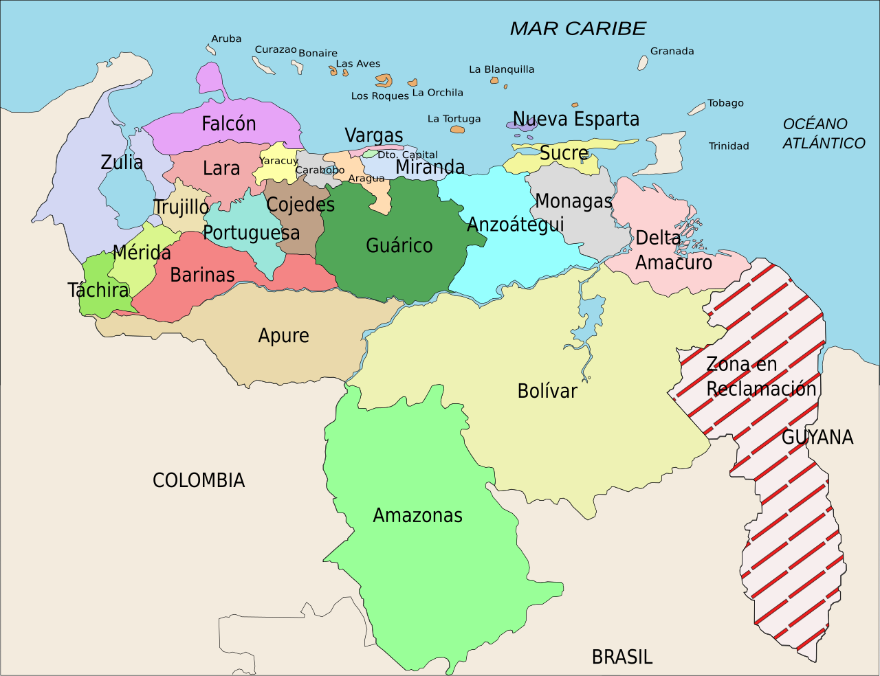
Español: División Político Territorial de Venezuela. Es un mapa acerca de los estados de Venezuela o división político territorial. La zona en reclamación aun no se sabe si pertenece a Guyana o a Venezuela, por eso se suele colocar de esa manera.
English: Political divisions of Venezuela. The Reclamation zone is Guyanan territory claimed by Venezuela. |
| Data | |
| Font | self work, Image:Venezuela politica copy.png based |
| Autor | Wilfredor |
| Permís (Com reutilitzar aquest fitxer) |
Own work, copyleft: Multi-license with GFDL and Creative Commons CC-BY-SA-2.5 and older versions (2.0 and 1.0) |
| Altres versions |
Derivative works of this file: Venezuela Division Politica Territorial mk.svg
[]
|


Aquesta imatge vectorial ha estat creada amb Inkscape .
Jo, el titular dels drets d'autor d'aquest treball, el public sota les següents llicències:

|
S'autoritza la còpia, la distribució i la modificació d'aquest document sota els termes de la llicència de documentació lliure GNU versió 1.2 o qualsevol altra versió posterior que publiqui la Free Software Foundation; sense seccions invariants, ni textos de portada, ni textos de contraportada. S'inclou una còpia d'aquesta llicència en la secció titulada GNU Free Documentation License. |
| Aquest fitxer està subjecte a la llicència de Creative Commons Reconeixement i Compartir Igual 3.0 No adaptada. | ||
| ||
| Aquest avís de llicència s'ha afegit a aquest fitxer d'acord amb l'actualització de la llicència GFDL. |
Aquest fitxer està llicenciat sota les llicències de Creative Commons Reconeixement - CompartirIgual 2.5 Genèrica, 2.0 Genèrica i 1.0 Genèrica.
- Sou lliure de:
- compartir – copiar, distribuir i comunicar públicament l'obra
- adaptar – fer-ne obres derivades
- Amb les condicions següents:
- reconeixement – Heu de donar la informació adequada sobre l'autor, proporcionar un enllaç a la llicència i indicar si s'han realitzat canvis. Podeu fer-ho amb qualsevol mitjà raonable, però de cap manera no suggereixi que l'autor us dóna suport o aprova l'ús que en feu.
- compartir igual – Si modifiqueu, transformeu, o generareu amb el material, haureu de distribuir les vostres contribucions sota una llicència similar o una de compatible com l'original
Podeu seleccionar la llicència que vulgueu.
Historial del fitxer
Cliqueu una data/hora per veure el fitxer tal com era aleshores.
| Data/hora | Miniatura | Dimensions | Usuari/a | Comentari | |
|---|---|---|---|---|---|
| actual | 23:00, 16 abr 2008 | | 2.121 × 1.629 (141 Ko) | Wilfredor | {{Information |Description= '''(Spanish):''' División Político Territorial de Venezuela. Es un mapa acerca de los estados de Venezuela o división político territorial. La zona en reclamación aun no se sabe si pertenece a Guyana o a Venezuela, por es |
| 17:17, 21 abr 2007 |  | 2.121 × 1.629 (140 Ko) | Wilfredor | {{Information |Description= '''(Spanish):''' División Político Territorial de Venezuela. Es un mapa acerca de los estados de Venezuela o división político territorial. La zona en reclamación aun no se sabe si pertenece a Guyana o a Venezuela, por es | |
| 23:11, 19 abr 2007 |  | 2.121 × 1.629 (135 Ko) | Spundun | Reverted to earlier revision | |
| 23:10, 19 abr 2007 |  | 2.119 × 1.629 (135 Ko) | Spundun | Reverted to earlier revision | |
| 16:52, 19 abr 2007 |  | 2.121 × 1.629 (135 Ko) | Wilfredor | {{Information |Description= '''(Spanish):''' División Político Territorial de Venezuela </br> '''(English):''' Politic Territorial Division of Venezuela |Source=self work, Image:Venezuela politica copy.png based |Date=2007 |Author=[[user:wilfredo | |
| 02:33, 18 abr 2007 |  | 2.119 × 1.629 (135 Ko) | Wilfredor | {{Information |Description= '''(Spanish):''' División Político Territorial de Venezuela </br> '''(English):''' Politic Territorial Division of Venezuela |Source=self work |Date=2007 |Author=Wilfredo R. Rodriguez H. |Permission=Own wo | |
| 01:55, 18 abr 2007 |  | 2.119 × 1.629 (124 Ko) | Wilfredor | {{Information |Description= '''(Spanish):''' División Político Territorial de Venezuela </br> '''(English):''' Politic Territorial Division of Venezuela |Source=self work |Date=2007 |Author=Wilfredo R. Rodriguez H. |Permission=Own wo | |
| 22:56, 17 abr 2007 |  | 2.160 × 1.664 (107 Ko) | Wilfredor | {{Information |Description= '''(Spanish):''' División Político Territorial de Venezuela </br> '''(English):''' Politic Territorial Division of Venezuela |Source=self work |Date=2007 |Author=Wilfredo R. Rodriguez H. |Permission=Own wo | |
| 15:30, 17 abr 2007 |  | 2.160 × 1.664 (88 Ko) | Wilfredor | {{Information |Description= '''(Spanish):''' División Político Territorial de Venezuela </br> '''(English):''' Politic Territorial Division of Venezuela |Source=self work |Date=2007 |Author=Wilfredo R. Rodriguez H. |Permission=Own wo | |
| 04:54, 17 abr 2007 |  | 2.160 × 1.664 (83 Ko) | Wilfredor | {{Information |Description= '''(Spanish):''' División Político Territorial de Venezuela </br> '''(English):''' Politic Territorial Division of Venezuela |Source=self work |Date=2007 |Author=Wilfredo R. Rodriguez H. |Permission=Own wo |
Ús del fitxer
No hi ha pàgines que utilitzin aquest fitxer.
Ús global del fitxer
Utilització d'aquest fitxer en altres wikis:
- Utilització a an.wikipedia.org
- Utilització a be.wikipedia.org
- Utilització a br.wikipedia.org
- Utilització a bs.wikipedia.org
- Utilització a cs.wikipedia.org
- Utilització a da.wikipedia.org
- Utilització a de.wikipedia.org
- Utilització a en.wikipedia.org
- Utilització a es.wikipedia.org
- Categoría:Estados de Venezuela
- Wikiproyecto Discusión:Venezuela/1
- Categoría:Municipios de Venezuela
- Usuario:Dezulovic
- Anexo:Gobernadores de Venezuela
- Agua potable y saneamiento en Venezuela
- Categoría:Geografía de Venezuela por estado
- Categoría:Localidades de Venezuela por estado
- Wikiproyecto:Relaciones bilaterales/creados
- Utilització a es.wikibooks.org
- Utilització a es.wikinews.org
- Utilització a fiu-vro.wikipedia.org
- Utilització a fi.wikipedia.org
- Utilització a frr.wikipedia.org
- Utilització a fr.wikipedia.org
- Projet:Géographie/Palettes de navigation
- Modèle:Palette États du Venezuela
- États du Venezuela
- État de Bolívar
- État de La Guaira
- État de Táchira
- État de Lara
- État de Falcón
- État d'Yaracuy
- État de Carabobo
- État de Zulia
- État de Portuguesa
- État de Trujillo
- État de Cojedes
- État d'Aragua
- État d'Amazonas (Venezuela)
- État de Guárico
- État de Barinas
Vegeu més usos globals d'aquest fitxer.