
Fitxer:VictoriaIslandMap.png
No hi ha cap versió amb una resolució més gran.
VictoriaIslandMap.png (504 × 540 píxels, mida del fitxer: 27 Ko, tipus MIME: image/png)
| Aquest fitxer i la informació mostrada a continuació provenen del dipòsit multimèdia lliure Wikimedia Commons. |
Resum
| Descripció |
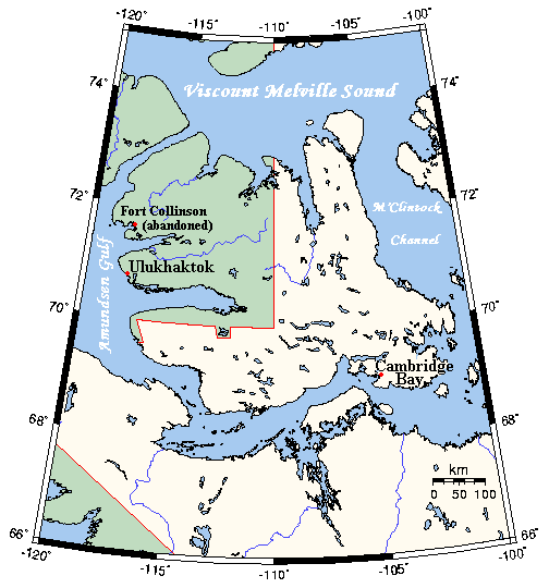
English: A map Victoria Island, Canada |
| Data | not specified |
| Font | This map's source is here, with the uploader's modifications, and the GMT homepage says that the tools are released under the GNU General Public License |
| Autor | Kelisi at en.wikipedia |
Llicència
Kelisi from en.wikipedia.org, el titular dels drets d'autor d'aquest treball, el public sota la següent llicència:
| Aquest fitxer està subjecte a la llicència de Creative Commons Reconeixement i Compartir Igual 3.0 No adaptada. Subjecte a l'avís legal. | ||
| Reconeixement: Kelisi from en.wikipedia.org | ||
| ||
| Aquest avís de llicència s'ha afegit a aquest fitxer d'acord amb l'actualització de la llicència GFDL. |

|
S'autoritza la còpia, la distribució i la modificació d'aquest document sota els termes de la llicència de documentació lliure GNU versió 1.2 o qualsevol altra versió posterior que publiqui la Free Software Foundation; sense seccions invariants, ni textos de portada, ni textos de contraportada. S'inclou una còpia d'aquesta llicència en la secció titulada GNU Free Documentation License. Subjecte a l'avís legal. |
Registre original de càrregues
All following user names refer to en.wikipedia.
- 2006-03-25 03:16 Kelisi 504×540×8 (21 KB) (A map of Victoria Island in the Northwest Territories and Nunavut. This map's source is [http://www.aquarius.geomar.de/omc/make_map.html here], with the uploader's modifications, and the [http://gmt.soest.hawaii.edu/ GMT homepage] says that the tools are )
Historial del fitxer
Cliqueu una data/hora per veure el fitxer tal com era aleshores.
| Data/hora | Miniatura | Dimensions | Usuari/a | Comentari | |
|---|---|---|---|---|---|
| actual | 03:53, 31 gen 2021 | | 504 × 540 (27 Ko) | Kelisi | Oops! That was silly. Sorry, I'll try again.......... |
| 03:50, 31 gen 2021 |  | 504 × 540 (27 Ko) | Kelisi | Inhabited hamlets' names have been rendered in bigger type (Fort Collinson has been left smaller), and the local name Ulukhaktok has replaced the former, English name Holman, since the article about the place now has that title. | |
| 13:32, 13 ago 2008 |  | 504 × 540 (21 Ko) | Telim tor | == Information == {{Information |Description={{en|A map Victoria Island, Canada}} |Source=This map's source is [http://www.aquarius.ifm-geomar.de/ here], with the uploader's modifications, and the [http://gmt.soest.hawaii.edu/ GMT homepage] says that the |
Ús del fitxer
Les 2 pàgines següents utilitzen aquest fitxer:
Ús global del fitxer
Utilització d'aquest fitxer en altres wikis:
- Utilització a af.wikipedia.org
- Utilització a bg.wikipedia.org
- Utilització a bs.wikipedia.org
- Utilització a ckb.wikipedia.org
- Utilització a da.wikipedia.org
- Utilització a en.wikipedia.org
- Utilització a eo.wikipedia.org
- Utilització a es.wikipedia.org
- Utilització a fa.wikipedia.org
- Utilització a gl.wikipedia.org
- Utilització a hu.wikipedia.org
- Utilització a ilo.wikipedia.org
- Utilització a nn.wikipedia.org
- Utilització a no.wikipedia.org
- Utilització a pl.wikipedia.org
- Utilització a ro.wikipedia.org
- Utilització a th.wikipedia.org
- Utilització a tt.wikipedia.org
- Utilització a www.wikidata.org
- Utilització a zh.wikipedia.org