
Fitxer:Adygea districts.png

Mida d'aquesta previsualització: 785 × 600 píxels. Altres resolucions: 314 × 240 píxels | 628 × 480 píxels | 1.013 × 774 píxels.
Fitxer original (1.013 × 774 píxels, mida del fitxer: 56 Ko, tipus MIME: image/png)
| Aquest fitxer i la informació mostrada a continuació provenen del dipòsit multimèdia lliure Wikimedia Commons. |
Resum
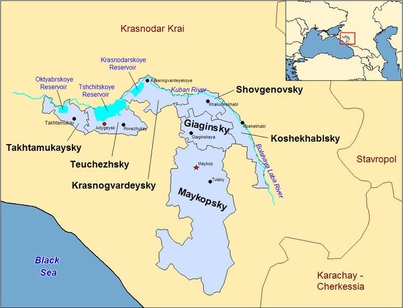
| Descripció | Map of the districts of the Adygea republic of Russia. Created by Rarelibra 13:10, 30 March 2007 (UTC) for public domain use, using MapInfo Professional v8.5 and various mapping resources. |
| Data | 30 de març de 2007 (original upload date) |
| Font | No machine-readable source provided. Own work assumed (based on copyright claims). |
| Autor | No machine-readable author provided. Rarelibra assumed (based on copyright claims). |
Previous summary and history (en.wikipedia)
Map of the districts of the Republic of Adygea (federal subject of Russia). Created by Rarelibra 20:52, 20 December 2006 (UTC) for public domain use, using MapInfo Professional v8.5 and various mapping resources. Special thanks to w:User:Ezhiki for both his patience and input to help complete this map for his wiki project.
- 16:06, April 3, 2007 . . Rarelibra (Talk | contribs | block) . . 1056×816 (58,397 bytes) (Updated version)
- 17:35, March 27, 2007 . . Rarelibra (Talk | contribs | block) . . 823×752 (50,852 bytes) (Updated map)
- 22:34, December 20, 2006 . . Rarelibra (Talk | contribs | block) . . 1281×878 (48,913 bytes) (Map of the districts of the Republic of Adygea (a federal subject of Russia). Created by ~~~~ for public domain use with attribution under GNU. Created using MapInfo Professional v8.5 and various mapping resources. Special thanks to User:Ezhiki for hi)
- 20:52, December 20, 2006 . . Rarelibra (Talk | contribs | block) . . 1281×878 (43,557 bytes) (Map of the districts of the Republic of Adygea (federal subject of Russia). Created by ~~~~ for public domain use, using MapInfo Professional v8.5 and various mapping resources. Special thanks to User:Ezhiki for both his patience and input to help com)
Llicència
| Jo, el titular del copyright d'aquesta obra, l'allibero al domini públic. Això s'aplica a tot el món. En alguns països això pot no ser legalment possible, en tal cas: Jo faig concessió a tothom del dret d'usar aquesta obra per a qualsevol propòsit, sense cap condició llevat d'aquelles requerides per la llei. |
Historial del fitxer
Cliqueu una data/hora per veure el fitxer tal com era aleshores.
| Data/hora | Miniatura | Dimensions | Usuari/a | Comentari | |
|---|---|---|---|---|---|
| actual | 00:53, 1 gen 2024 | | 1.013 × 774 (56 Ko) | User-duck | Cropped border using CropTool with lossless mode. |
| 15:18, 23 abr 2007 |  | 1.056 × 816 (57 Ko) | Rarelibra | Reverted to earlier revision | |
| 17:54, 21 abr 2007 |  | 1.056 × 816 (46 Ko) | David Kernow~commonswiki | ||
| 18:04, 3 abr 2007 |  | 1.056 × 816 (57 Ko) | Rarelibra | Updated version | |
| 15:10, 30 març 2007 |  | 823 × 752 (50 Ko) | Rarelibra | Map of the districts of the Adygea republic of Russia. Created by ~~~~ for public domain use, using MapInfo Professional v8.5 and various mapping resources. |
Ús del fitxer
La pàgina següent utilitza aquest fitxer:
Ús global del fitxer
Utilització d'aquest fitxer en altres wikis:
- Utilització a af.wikipedia.org
- Utilització a azb.wikipedia.org
- Utilització a cy.wikipedia.org
- Utilització a de.wikipedia.org
- Utilització a el.wikipedia.org
- Utilització a en.wikipedia.org
- Utilització a fa.wikipedia.org
- Utilització a fi.wikipedia.org
- Utilització a frr.wikipedia.org
- Utilització a fr.wikipedia.org
- Utilització a incubator.wikimedia.org
- Utilització a io.wikipedia.org
- Utilització a it.wikipedia.org
- Utilització a krc.wikipedia.org
- Utilització a lv.wikipedia.org
- Utilització a mn.wikipedia.org
- Utilització a nl.wikipedia.org
- Utilització a pl.wikipedia.org
- Utilització a pl.wiktionary.org
- Utilització a pt.wikipedia.org
- Utilització a ru.wikivoyage.org