
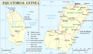
Fitxer:Annobón Bioko.PNG

Fitxer original (1.894 × 1.100 píxels, mida del fitxer: 502 Ko, tipus MIME: image/png)
| Aquest fitxer i la informació mostrada a continuació provenen del dipòsit multimèdia lliure Wikimedia Commons. |
Resum
| Descripció | |
| Data | |
| Font | http://www.un.org/Depts/Cartographic/map/profile/eqguinea.pdf |
| Autor | |
| Altres versions |
Derivative works of this file: |
Llicència
| This image is a map derived from a United Nations map.
Unless stated otherwise, UN maps are to be considered in the public domain. This applies worldwide. UN maps are, in principle, open source material and you can use them in your work or for making your own map. UN requests however that you delete the UN name, logo and reference number upon any modification to the map. Content of your map will be your responsibility. You can state in your publication, if you wish, something like: based on UN map … (map name, map number, revision number and date). See: Geospatial Information Section. And: Geospatial, location data for a better world. |
 |
Historial del fitxer
Cliqueu una data/hora per veure el fitxer tal com era aleshores.
| Data/hora | Miniatura | Dimensions | Usuari/a | Comentari | |
|---|---|---|---|---|---|
| actual | 21:12, 15 juny 2016 | | 1.894 × 1.100 (502 Ko) | W like wiki | + lower margin |
| 19:26, 15 juny 2016 |  | 1.895 × 1.098 (501 Ko) | W like wiki | Now all coordinates are more clear: E for EAST, N for NORTH, S for SOUTH !!! | |
| 19:04, 15 juny 2016 |  | 1.895 × 1.098 (500 Ko) | W like wiki | link=|55px Even though the source of this file is the UN, the lower latitude coordinates of Annobón (located on the southern hemisphere!) seems to be '''wrong''', so '''1°27′''' is now used instead of '''1°23... | |
| 13:05, 7 set 2014 |  | 1.895 × 1.098 (499 Ko) | Basquetteur | Corrected to amend wrong spelling of Bioko (Isla de Boiko in original UN map) and also uploading a higher resolution version | |
| 05:47, 20 maig 2005 |  | 946 × 553 (88 Ko) | Taichi | Mapa de Annobón y Bioko. Guinea Ecuatorial {{PD}} Fuente: http://www.un.org/Depts/Cartographic/map/profile/eqguinea.pdf |
Ús del fitxer
No hi ha pàgines que utilitzin aquest fitxer.
Ús global del fitxer
Utilització d'aquest fitxer en altres wikis:
- Utilització a an.wikipedia.org
- Utilització a azb.wikipedia.org
- Utilització a de.wikipedia.org
- Utilització a en.wikipedia.org
- Utilització a eo.wikipedia.org
- Utilització a es.wikipedia.org
- Utilització a et.wikipedia.org
- Utilització a fr.wikipedia.org
- Utilització a gl.wikipedia.org
- Utilització a it.wikipedia.org
- Utilització a ja.wikipedia.org
- Utilització a ko.wikipedia.org
- Utilització a ml.wikipedia.org
- Utilització a pl.wikipedia.org
- Utilització a pt.wikipedia.org
- Utilització a ru.wikipedia.org
- Utilització a sco.wikipedia.org
- Utilització a sh.wikipedia.org
- Utilització a uk.wikipedia.org
- Utilització a ur.wikipedia.org
- Utilització a vi.wikipedia.org
- Utilització a wuu.wikipedia.org
- Utilització a zh.wikipedia.org
- Utilització a zu.wikipedia.org