
Fitxer:Cape Verde hurricane track.jpg

Mida d'aquesta previsualització: 800 × 296 píxels. Altres resolucions: 320 × 118 píxels | 640 × 237 píxels | 1.024 × 379 píxels | 2.550 × 944 píxels.
Fitxer original (2.550 × 944 píxels, mida del fitxer: 317 Ko, tipus MIME: image/jpeg)
| Aquest fitxer i la informació mostrada a continuació provenen del dipòsit multimèdia lliure Wikimedia Commons. |
| Descripció |
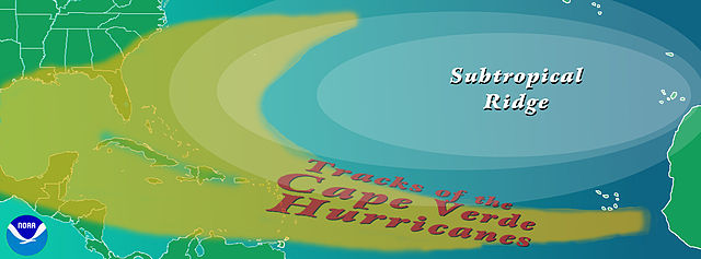
English: Graphic showing the typical track of a en:Cape Verde-type hurricane. The tracks begin south of en:Cape Verde in the eastern en:Atlantic Ocean.
Copyright statusThe NOAA emblem is the property of the U.S. Government and a trademark of the en:United States Department of Commerce. SourceNOAA graphic from http://www.aoml.noaa.gov/hrd/tcfaq/CVtrak.jpg en:nl:Afbeelding:KaapverdischeOrkanen.jpg |
| Data | 16 de juliol de 2004 (original upload date) |
| Font | Transferred from en.wikipedia to Commons by OhanaUnited. |
| Autor | The original uploader was Cyrius de la Viquipèdia en anglès. |
| Altres versions |
|
Llicència


This image is in the public domain because it contains materials that originally came from the U.S. National Oceanic and Atmospheric Administration, taken or made as part of an employee's official duties.
|
Registre original de càrregues
La pàgina de descripció original era aquí. Els noms d'usuari a continuació es refereixen a en.wikipedia.
- 2004-07-16 00:36 Cyrius 2550×944×??? (324839 bytes) PD graphic from NOAA
Historial del fitxer
Cliqueu una data/hora per veure el fitxer tal com era aleshores.
| Data/hora | Miniatura | Dimensions | Usuari/a | Comentari | |
|---|---|---|---|---|---|
| actual | 19:40, 21 ago 2008 | 2.550 × 944 (317 Ko) | OhanaUnited | {{Information |Description={{en|Graphic showing the typical track of a en:Cape Verde-type hurricane. The tracks begin south of en:Cape Verde in the eastern en:Atlantic Ocean. ==Copyright status== The NOAA emblem is the property of the [[:e |
Ús del fitxer
La pàgina següent utilitza aquest fitxer:
Ús global del fitxer
Utilització d'aquest fitxer en altres wikis:
- Utilització a en.wikipedia.org
- Utilització a es.wikipedia.org
- Utilització a eu.wikipedia.org
- Utilització a fr.wikipedia.org
- Utilització a it.wikipedia.org
- Utilització a ko.wikipedia.org
- Utilització a nl.wikipedia.org
- Utilització a pt.wikipedia.org
- Utilització a uk.wikipedia.org
- Utilització a www.wikidata.org