
Fitxer:Central African Republic Map.jpg

Mida d'aquesta previsualització: 573 × 600 píxels. Altres resolucions: 229 × 240 píxels | 459 × 480 píxels | 972 × 1.017 píxels.
Fitxer original (972 × 1.017 píxels, mida del fitxer: 554 Ko, tipus MIME: image/jpeg)
| Aquest fitxer i la informació mostrada a continuació provenen del dipòsit multimèdia lliure Wikimedia Commons. |
| Descripció |
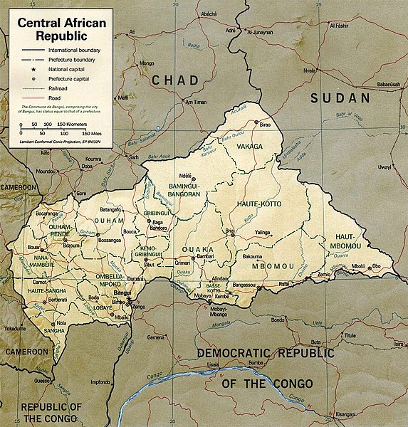
English: Shaded relief map of the Central African Republic.
|
|||
| Data | ||||
| Font | [1] from the Perry-Castañeda Library Map Collection. | |||
| Autor | CIA | |||
| Permís (Com reutilitzar aquest fitxer) |
|

![[1]](http://www.lib.utexas.edu/maps/africa/cen_african_rep_rel01.jpg)
Historial del fitxer
Cliqueu una data/hora per veure el fitxer tal com era aleshores.
| Data/hora | Miniatura | Dimensions | Usuari/a | Comentari | |
|---|---|---|---|---|---|
| actual | 21:15, 5 jul 2011 | | 972 × 1.017 (554 Ko) | Ras67 | cropped and slightly leveled |
| 13:53, 21 feb 2006 |  | 1.032 × 1.076 (261 Ko) | Lupo | Shaded relief map of the Central African Republic. Source: [http://www.lib.utexas.edu/maps/africa/cen_african_rep_rel01.jpg] from the [http://www.lib.utexas.edu/maps/central_african_republic.html Perry-Castañeda Library Map Collection]. {{PD-USGov- |
Ús del fitxer
La pàgina següent utilitza aquest fitxer:
Ús global del fitxer
Utilització d'aquest fitxer en altres wikis:
- Utilització a en.wikipedia.org
- Utilització a fa.wikipedia.org
- Utilització a fr.wikipedia.org
- Utilització a it.wikipedia.org
- Utilització a ka.wikipedia.org
- Utilització a lfn.wikipedia.org
- Utilització a lt.wikipedia.org
- Utilització a mdf.wikipedia.org
- Utilització a mk.wikipedia.org
- Utilització a nl.wikipedia.org
- Utilització a pl.wikipedia.org
- Utilització a ru.wikipedia.org
- Utilització a sn.wikipedia.org
- Utilització a su.wikipedia.org
- Utilització a tt.wikipedia.org
- Utilització a uk.wikipedia.org
- Utilització a vec.wikipedia.org
- Utilització a www.wikidata.org
- Utilització a zh.wikipedia.org