
Fitxer:Governor's Island.svg

Mida d'aquesta previsualització PNG del fitxer SVG: 700 × 450 píxels. Altres resolucions: 320 × 206 píxels | 640 × 411 píxels | 1.024 × 658 píxels | 1.280 × 823 píxels | 2.560 × 1.646 píxels.
Fitxer original (fitxer SVG, nominalment 700 × 450 píxels, mida del fitxer: 334 Ko)
| Aquest fitxer i la informació mostrada a continuació provenen del dipòsit multimèdia lliure Wikimedia Commons. |
|
This is an image of a place or building that is listed on the National Register of Historic Places in the United States of America. Its reference number is 85002435. |
| Descripció |
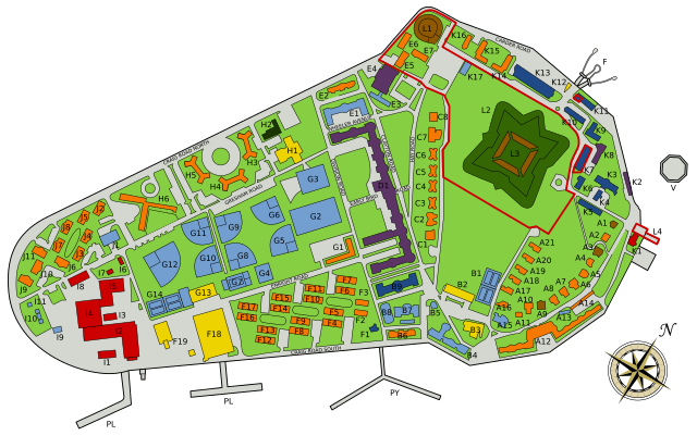
English: A map of Governor's Island, NY, USA. Showing buildings by type (color) and individually labelled. |
||
| Data | |||
| Font | Own work by uploader, based on File:Governors_Island.jpg, a PD image. | ||
| Autor | Inductiveload | ||
| Permís (Com reutilitzar aquest fitxer) |
|
| Posició de l'objecte | | Aquesta i altres imatges properes a: OpenStreetMap |
|---|
Key
| English | |
|---|---|
| City Historical Monument | |
| Residential | |
| Industrial | |
| Community Facility | |
| Offices | |
| Commercial | |
| Multi-Use | |
| National Park Boundary |
| English | |
|---|---|
| L1 | Castle Williams |
| L2 | Governer's Island National Monument |
| L3 | Fort Jay |
| L4 | Dock 104 |
| F | Ferry to Manhattan |
| D1 | Liggett Hall |
| PL | Lima Pier |
| PT | Tango Pier |
| PY | Yankee Pier |
| V | Brooklyn-Battery Tunnel Ventilation Shaft |
| A1 | ? |
Historial del fitxer
Cliqueu una data/hora per veure el fitxer tal com era aleshores.
| Data/hora | Miniatura | Dimensions | Usuari/a | Comentari | |
|---|---|---|---|---|---|
| actual | 02:15, 4 feb 2009 | | 700 × 450 (334 Ko) | Inductiveload | reduce size, so scaling shouldn't be necessary at full size. |
| 01:45, 4 feb 2009 |  | 1.400 × 900 (322 Ko) | Inductiveload | fix render problem | |
| 01:42, 4 feb 2009 |  | 200 × 90 (320 Ko) | Inductiveload | {{Information |Description={{en|1=A map of en:Governor's Island, en:NY, en:USA. Showing buildings by type (color) and individually labelled.}} |Source=Own work by uploader, based on File:Governors_Island.jpg, a PD image. |Author=[[U |
Ús del fitxer
La pàgina següent utilitza aquest fitxer:
Ús global del fitxer
Utilització d'aquest fitxer en altres wikis:
- Utilització a en.wikipedia.org
- Utilització a es.wikipedia.org
- Utilització a fa.wikipedia.org
- Utilització a fr.wikipedia.org
- Utilització a nl.wikipedia.org
- Utilització a pt.wikipedia.org
- Utilització a uk.wikipedia.org