
Fitxer:Guinea-CIA WFB Map.png
No hi ha cap versió amb una resolució més gran.
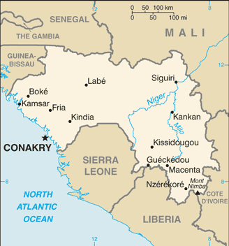
Guinea-CIA_WFB_Map.png (328 × 352 píxels, mida del fitxer: 19 Ko, tipus MIME: image/png)
| Aquest fitxer i la informació mostrada a continuació provenen del dipòsit multimèdia lliure Wikimedia Commons. |
- See also the 2004 version.
.png)
This image is in the public domain because it contains materials that originally came from the United States Central Intelligence Agency's World Factbook.
|
 |
Historial del fitxer
Cliqueu una data/hora per veure el fitxer tal com era aleshores.
| Data/hora | Miniatura | Dimensions | Usuari/a | Comentari | |
|---|---|---|---|---|---|
| actual | 07:40, 21 jul 2007 | | 328 × 352 (19 Ko) | Hoshie | Updated map of Guinea from the CIA World Factbook, 14 June 07 rev. Src: https://www.cia.gov/library/publications/the-world-factbook/maps/gv-map.gif |
| 04:48, 10 feb 2007 |  | 330 × 353 (17 Ko) | Hoshie | Updated map of Guinea from the CIA Factbook, 8 Feb 07 rev. Source : https://www.cia.gov/cia/publications/factbook/maps/gv-map.gif | |
| 11:14, 27 març 2005 |  | 330 × 355 (11 Ko) | Wolfman~commonswiki | {{CIA-map}} |
Ús del fitxer
Les 4 pàgines següents utilitzen aquest fitxer:
Ús global del fitxer
Utilització d'aquest fitxer en altres wikis:
- Utilització a bn.wikipedia.org
- Utilització a cs.wikipedia.org
- Utilització a en.wikipedia.org
- Utilització a en.wikisource.org
- Utilització a fa.wikipedia.org
- Utilització a fi.wikipedia.org
- Utilització a fr.wikipedia.org
- Utilització a he.wikipedia.org
- Utilització a id.wikipedia.org
- Utilització a ja.wikipedia.org
- Utilització a kn.wikipedia.org
- Utilització a ml.wikipedia.org
- Utilització a mt.wikipedia.org
- Utilització a no.wikipedia.org
- Utilització a pl.wikipedia.org
- Utilització a pt.wikipedia.org
- Utilització a si.wikipedia.org
- Utilització a sl.wikipedia.org
- Utilització a th.wikipedia.org
- Utilització a uk.wikipedia.org
- Utilització a uz.wikipedia.org