
Fitxer:Heteralocha acutirostris distribution.png
Mida d'aquesta previsualització: 451 × 600 píxels. Altres resolucions: 180 × 240 píxels | 361 × 480 píxels | 577 × 768 píxels | 1.070 × 1.423 píxels.
Fitxer original (1.070 × 1.423 píxels, mida del fitxer: 135 Ko, tipus MIME: image/png)
| Aquest fitxer i la informació mostrada a continuació provenen del dipòsit multimèdia lliure Wikimedia Commons. |
Resum
| Descripció |
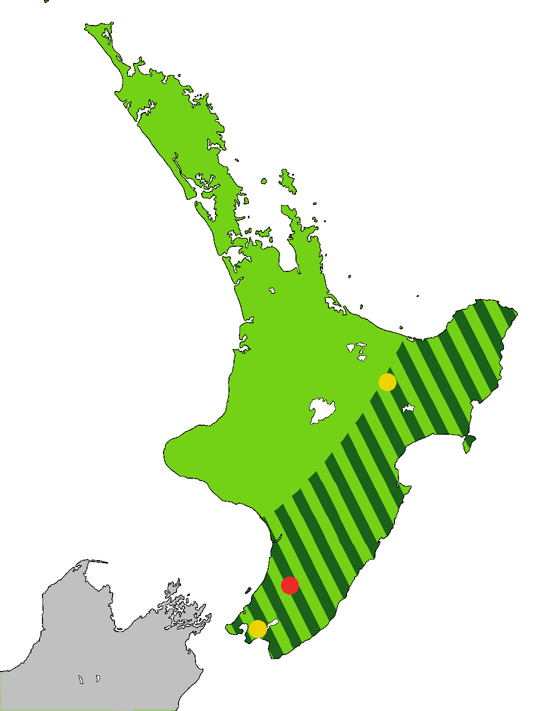
English: Light green: Range of the Huia, Heteralocha acutirostris, before the arrival of humans to New Zealand, as indicated by fossils. Dark green stripes: Range at 1840. Last sightings of the Huia: Red - last confirmed sighting in 1907 in Tararua Range. Yellow x 2 include one behind Eastbourne at the southern end of the North Island, and one in the Te Urewera National Park. The Huia is an extinct bird that was endemic to the North Island of New Zealand
Čeština: Laločník ostrozobý – distribuce. Světle zeleně: původní rozšíření laločníka ostrozobého; tmavě zelenými pruhy: rozsah druhu kolem roku 1840; červený bod: poslední potvrzené pozorování; žlutý bod: neověřená pozorování |
| Data | |
| Font | Treball propi. Based on first version by Casliber with information provided by User:Kotare, using as a base for the outline File:New Zealand location map transparent.svg adapted by uploader User:Kahuroa |
| Autor | Kahuroa |
Llicència
| S'ha alliberat aquesta obra al domini públic pel seu autor Kahuroa. Això s'aplica a tot el món. En alguns països això pot no ser legalment possible, en tal cas: |
Historial del fitxer
Cliqueu una data/hora per veure el fitxer tal com era aleshores.
| Data/hora | Miniatura | Dimensions | Usuari/a | Comentari | |
|---|---|---|---|---|---|
| actual | 20:36, 14 set 2010 | | 1.070 × 1.423 (135 Ko) | Kahuroa | Use new outline source: File:New Zealand location map transparent.svg adapted by uploader User:Kahuroa |
| 09:31, 31 ago 2010 |  | 1.760 × 2.346 (220 Ko) | Kahuroa | New map - uses stripes to denote range in 1840 | |
| 23:46, 21 jul 2010 |  | 449 × 599 (49 Ko) | Casliber | {{Information |Description= |Source={{own}} |Date= |Author= Casliber |Permission= |other_versions= }} | |
| 23:04, 21 jul 2010 |  | 449 × 599 (49 Ko) | Casliber | {{Information |Description= Map added last sitings of the Huia. Red - last confirmed siting in 1907 in Tararua Range. Yellow x 2 include one behind Eastbourne, and one in the Te Urewera National Park. |Source={{own}} |Date= 23rd July 2010 |Author= [[User: | |
| 22:52, 21 jul 2010 |  | 449 × 599 (48 Ko) | Casliber | {{Information |Description={{en|1=Map of deforestation of North Island on New Zealand}} |Source={{own}} |Author=Casliber |Date=22nd July 2010 |Permission=yes |other_versions=no }} Category:Maps |
Ús del fitxer
La pàgina següent utilitza aquest fitxer:
Ús global del fitxer
Utilització d'aquest fitxer en altres wikis:
- Utilització a ar.wikipedia.org
- Utilització a bn.wikipedia.org
- Utilització a ceb.wikipedia.org
- Utilització a cs.wikipedia.org
- Utilització a en.wikipedia.org
- Utilització a es.wikipedia.org
- Utilització a eu.wikipedia.org
- Utilització a fa.wikipedia.org
- Utilització a gl.wikipedia.org
- Utilització a he.wikipedia.org
- Utilització a hu.wikipedia.org
- Utilització a id.wikipedia.org
- Utilització a it.wikipedia.org
- Utilització a nn.wikipedia.org
- Utilització a pl.wikipedia.org
- Utilització a pt.wikipedia.org
- Utilització a ru.wikipedia.org
- Utilització a sr.wikipedia.org
- Utilització a sv.wikipedia.org
- Utilització a ta.wikipedia.org
- Utilització a uk.wikipedia.org
- Utilització a vi.wikipedia.org
- Utilització a www.wikidata.org
- Utilització a zh.wikipedia.org