
Fitxer:Hudson bay explorer.png
Hudson_bay_explorer.png (550 × 442 píxels, mida del fitxer: 449 Ko, tipus MIME: image/png)
| Aquest fitxer i la informació mostrada a continuació provenen del dipòsit multimèdia lliure Wikimedia Commons. |
| Descripció |
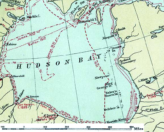
English: Map of the routes of the main European explorers in Hudson Bay, Canada. |
|||||
| Data | ||||||
| Font | Excerpted from 1st Edition, 1906, Atlas of Canada - Routes of Explorers,1497 to 1905. | |||||
| Autor | Department of the Interior, Ottawa | |||||
| Permís (Com reutilitzar aquest fitxer) |
Crown copyright expired.
|

Registre original de càrregues
- 2007-01-26 22:28 CyclePat 550×442×8 (459278 bytes) ==Description== This map shows the routes followed by the principal explorers of what is now Canada, from 1497 up to 1905. The map also shows the location of forts with the date of their establishment. It was created using [[:image:Canada, Routes of Explo
Historial del fitxer
Cliqueu una data/hora per veure el fitxer tal com era aleshores.
| Data/hora | Miniatura | Dimensions | Usuari/a | Comentari | |
|---|---|---|---|---|---|
| actual | 13:41, 10 jul 2008 | | 550 × 442 (449 Ko) | Urdangaray | {{Information |Description={{en|thumb|400px|right|Canada, Routes of Explorers,1497 to 1905 This map shows the routes followed by the principal explorers of what is now Canada, from 1497 up to 190 |
Ús del fitxer
Les 2 pàgines següents utilitzen aquest fitxer:
Ús global del fitxer
Utilització d'aquest fitxer en altres wikis:
- Utilització a arz.wikipedia.org
- Utilització a ast.wikipedia.org
- Utilització a az.wikipedia.org
- Utilització a bg.wikipedia.org
- Utilització a cv.wikipedia.org
- Utilització a de.wikipedia.org
- Utilització a en.wikipedia.org
- Utilització a es.wikipedia.org
- Utilització a hi.wikipedia.org
- Utilització a nn.wikipedia.org
- Utilització a ru.wikipedia.org
- Utilització a zh.wikipedia.org