
Fitxer:Illinois Traction System Minooka Passenger Station.jpg

Mida d'aquesta previsualització: 800 × 597 píxels. Altres resolucions: 320 × 239 píxels | 640 × 478 píxels | 1.024 × 765 píxels | 1.280 × 956 píxels | 2.560 × 1.911 píxels | 4.721 × 3.525 píxels.
Fitxer original (4.721 × 3.525 píxels, mida del fitxer: 2,35 Mo, tipus MIME: image/jpeg)
| Aquest fitxer i la informació mostrada a continuació provenen del dipòsit multimèdia lliure Wikimedia Commons. |
| Descripció |
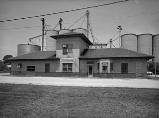
Illinois Traction System, Minooka Passenger Station, Minooka, Grundy County, IL. |
|||||||||||||||||||||||
| Data | ||||||||||||||||||||||||
| Font |
Historic American Buildings Survey HAER ILL, 32-MINK, 1-1
|
|||||||||||||||||||||||
| Autor |
|
|||||||||||||||||||||||
| Permís (Com reutilitzar aquest fitxer) |
|
|||||||||||||||||||||||

.jpg)
| Posició de l'objecte | | Aquesta i altres imatges properes a: OpenStreetMap |
|---|
Historial del fitxer
Cliqueu una data/hora per veure el fitxer tal com era aleshores.
| Data/hora | Miniatura | Dimensions | Usuari/a | Comentari | |
|---|---|---|---|---|---|
| actual | 00:35, 13 abr 2008 | | 4.721 × 3.525 (2,35 Mo) | Finavon | border cropped |
| 02:19, 31 març 2007 |  | 5.000 × 4.013 (2,54 Mo) | Dual Freq | {{Information |Description=Illinois Traction System, Minooka Passenger Station, Minooka, Grundy County, IL. (1. SOUTH FACADE OF STATION LOOKING NORTHWEST. HAER ILL, 32-MINK, 1-1) |Source=[http://memory.loc.gov/pnp/habshaer/il/il0600/il0650/photos/037235pu |
Ús del fitxer
La pàgina següent utilitza aquest fitxer:
Ús global del fitxer
Utilització d'aquest fitxer en altres wikis:
- Utilització a ar.wikipedia.org
- Utilització a ceb.wikipedia.org
- Utilització a cy.wikipedia.org
- Utilització a en.wikipedia.org
- Utilització a es.wikipedia.org
- Utilització a eu.wikipedia.org
- Utilització a fr.wikipedia.org
- Utilització a ht.wikipedia.org
- Utilització a it.wikipedia.org
- Utilització a lld.wikipedia.org
- Utilització a pl.wikipedia.org
- Utilització a pt.wikipedia.org
- Utilització a sh.wikipedia.org
- Utilització a sr.wikipedia.org
- Utilització a uk.wikipedia.org
- Utilització a vi.wikipedia.org
- Utilització a www.wikidata.org
- Utilització a zh-min-nan.wikipedia.org
- Utilització a zh.wikipedia.org