
Fitxer:Kilauea Lava Hazard Map.gif
No hi ha cap versió amb una resolució més gran.
Kilauea_Lava_Hazard_Map.gif (359 × 270 píxels, mida del fitxer: 18 Ko, tipus MIME: image/gif)
| Aquest fitxer i la informació mostrada a continuació provenen del dipòsit multimèdia lliure Wikimedia Commons. |
Resum
| Descripció |
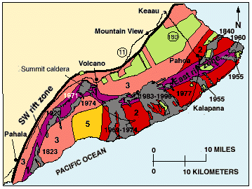
English: Hazard zones for lava flows on Kilauea. The flows erupted since 1800 are shown in gray and dated. Twenty-eight percent of the area encompassed by Zones 1 and 2 on the east half of the volcano has been covered by lava since 1955. The major housing subdivisions on the slopes of the volcano are shown in green. |
| Data | |
| Font | http://pubs.usgs.gov/gip/hazards/kilauea.html |
| Autor | USGS |
This is the work of the US Government and is in the public domain.
Llicència
Aquesta imatge és de domini públic, ja que conté materials que originalment van venir del Servei Geològic dels Estats Units d'Amèrica, una agència del Departament de l'Interior dels Estats Units. Per a obtenir més informació, consulti la política oficial de drets de l'USGS.
|
Historial del fitxer
Cliqueu una data/hora per veure el fitxer tal com era aleshores.
| Data/hora | Miniatura | Dimensions | Usuari/a | Comentari | |
|---|---|---|---|---|---|
| actual | 12:08, 27 maig 2010 | | 359 × 270 (18 Ko) | Infanalyst | {{Information |Description={{en|1=Hazard zones for lava flows on Kilauea. The flows erupted since 1800 are shown in gray and dated. Twenty-eight percent of the area encompassed by Zones 1 and 2 on the east half of the volcano has been covered by lava sinc |
Ús del fitxer
La pàgina següent utilitza aquest fitxer:
Ús global del fitxer
Utilització d'aquest fitxer en altres wikis:
- Utilització a en.wikipedia.org
- Utilització a fr.wikipedia.org