
Fitxer:MaineBoundaryDispute.jpg

Mida d'aquesta previsualització: 424 × 599 píxels. Altres resolucions: 170 × 240 píxels | 340 × 480 píxels | 780 × 1.102 píxels.
Fitxer original (780 × 1.102 píxels, mida del fitxer: 306 Ko, tipus MIME: image/jpeg)
| Aquest fitxer i la informació mostrada a continuació provenen del dipòsit multimèdia lliure Wikimedia Commons. |

|
Aquesta imatge (de tipus historical map) s'hauria de tornar a crear utilitzant gràfics vectorials com ara un fitxer SVG. Això té diversos avantatges; en trobareu més informació a Commons:Media for cleanup. Si ja disposeu d'una versió d'aquesta imatge en format SVG, us preguem que la pengeu; després, reemplaceu aquesta plantilla amb la plantilla {{Vector version available|nom nou de la imatge.svg}} en aquesta imatge.
|


Resum
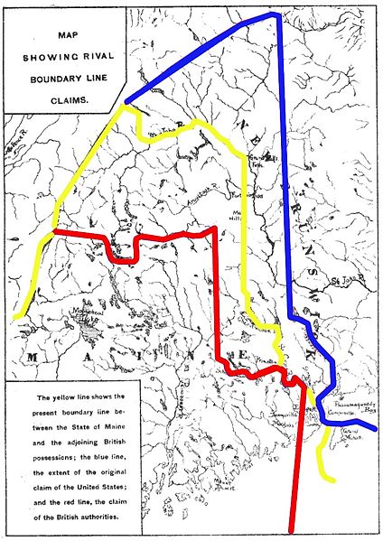
| Descripció | Map showing competing proposals for the boundary line between the US state of Maine and the British (now Canadian) province of New Brunswick. The red line marks the British proposal, the blue line marks the US proposal, and the yellow line marks the line agreed in the 1842 Webster-Ashburton Treaty, which resolved virtually all of the outstanding boundary issues in this area. |
| Data | Base map published 1888; annotations 2013 |
| Font | Annotations: own work |
| Autor | User:Magicpiano |
Llicència
| Jo, el titular del copyright d'aquesta obra, l'allibero al domini públic. Això s'aplica a tot el món. En alguns països això pot no ser legalment possible, en tal cas: Jo faig concessió a tothom del dret d'usar aquesta obra per a qualsevol propòsit, sense cap condició llevat d'aquelles requerides per la llei. |
Historial del fitxer
Cliqueu una data/hora per veure el fitxer tal com era aleshores.
| Data/hora | Miniatura | Dimensions | Usuari/a | Comentari | |
|---|---|---|---|---|---|
| actual | 17:18, 15 març 2013 | | 780 × 1.102 (306 Ko) | Magicpiano | swap red and blue to match inset text |
| 22:24, 18 feb 2013 |  | 780 × 1.102 (306 Ko) | Magicpiano | {{Information |Description=Map showing competing proposals for the boundary line between the US state of Maine and the British (now Canadian) province of New Brunswick. The blue line marks the British proposal, the red line marks the US proposal, and ... |
Ús del fitxer
La pàgina següent utilitza aquest fitxer:
Ús global del fitxer
Utilització d'aquest fitxer en altres wikis:
- Utilització a ar.wikipedia.org
- Utilització a en.wikipedia.org
- Utilització a es.wikipedia.org
- Utilització a fi.wikipedia.org
- Utilització a he.wikipedia.org
- Utilització a ja.wikipedia.org
- Utilització a pt.wikipedia.org
- Utilització a sv.wikipedia.org
- Utilització a www.wikidata.org