
Fitxer:Manchuria-U.S.S.R. boundary. LOC 2007627809.jpg

Mida d'aquesta previsualització: 784 × 599 píxels. Altres resolucions: 314 × 240 píxels | 628 × 480 píxels | 1.005 × 768 píxels | 1.280 × 978 píxels | 2.560 × 1.957 píxels | 4.167 × 3.185 píxels.
Fitxer original (4.167 × 3.185 píxels, mida del fitxer: 1,33 Mo, tipus MIME: image/jpeg)
| Aquest fitxer i la informació mostrada a continuació provenen del dipòsit multimèdia lliure Wikimedia Commons. |
Resum
| Descripció |
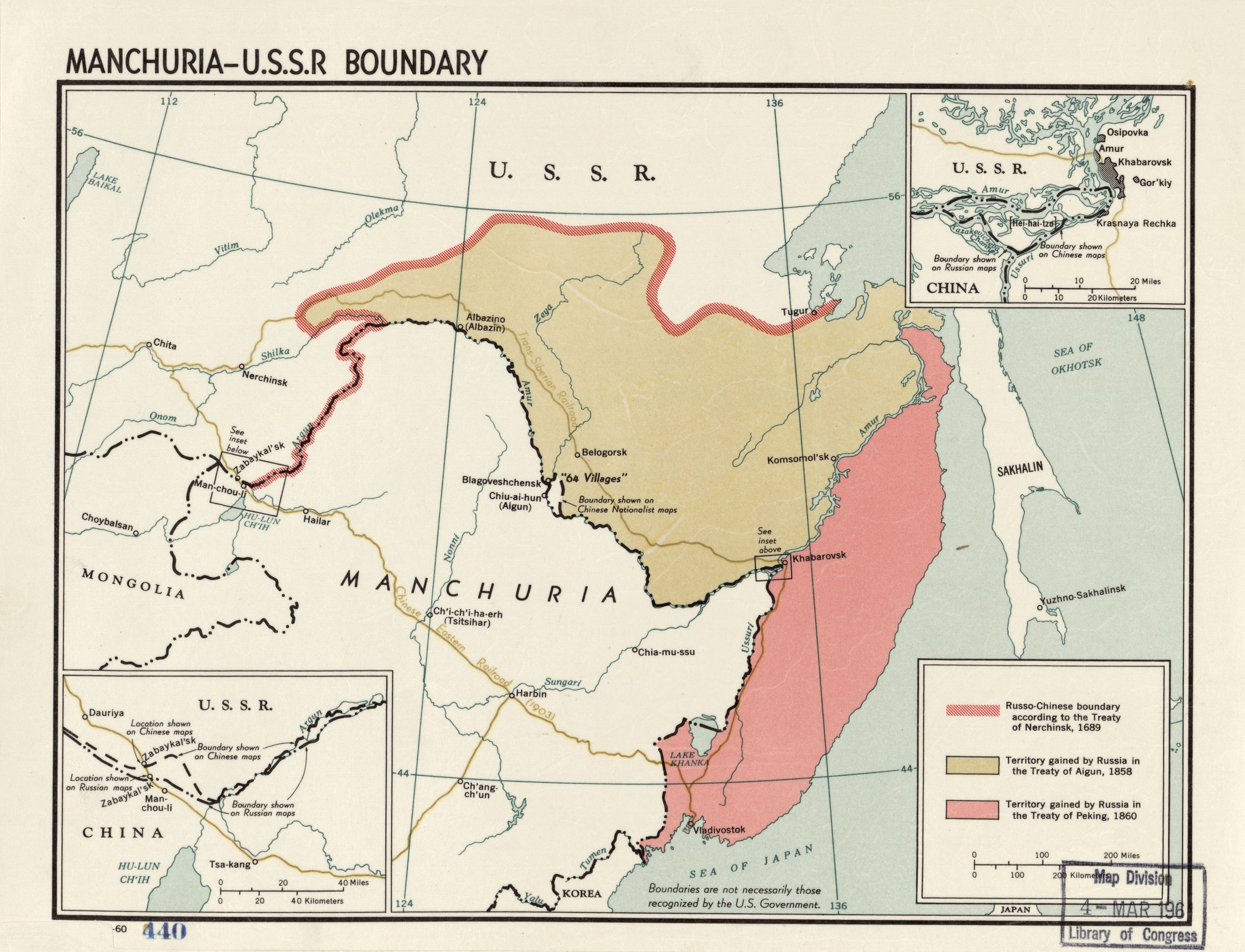
English: Includes 2 insets. LC copy mounted on cloth backing. LC copy stamped on: "440" In the bottom left corner: "-60." Available also through the Library of Congress Web site as a raster image. |
||
| Title | Manchuria-U.S.S.R. boundary. | ||
| Shelf ID | G7822.M2 1960 .U5 | ||
| Data | |||
| Font | https://www.loc.gov/item/2007627809/ | ||
| Autor | United States. Central Intelligence Agency | ||
| Permís (Com reutilitzar aquest fitxer) |
|
||
| Altres versions |
|
||
| Location | Manchuria · China · Soviet Union | ||
| Part of | American Memory · General Maps · Catalog · Geography And Map Division | ||
| Subject | Manchuria (China) · Manchuria · Boundaries · Maps · China · Soviet Union |

Llicència
| This image is a work of a Central Intelligence Agency employee, taken or made as part of that person's official duties. As a Work of the United States Government, this image or media is in the public domain in the United States.
|

|
Historial del fitxer
Cliqueu una data/hora per veure el fitxer tal com era aleshores.
| Data/hora | Miniatura | Dimensions | Usuari/a | Comentari | |
|---|---|---|---|---|---|
| actual | 15:06, 25 maig 2018 | | 4.167 × 3.185 (1,33 Mo) | Fæ | LOC Maps https://www.loc.gov/item/2007627809/ #980 |
Ús del fitxer
La pàgina següent utilitza aquest fitxer:
Ús global del fitxer
Utilització d'aquest fitxer en altres wikis:
- Utilització a he.wikipedia.org
- Utilització a id.wikipedia.org