
Fitxer:Map of Achaemenid Imperial Satraps (English Version).png

Fitxer original (3.308 × 1.648 píxels, mida del fitxer: 653 Ko, tipus MIME: image/png)
| Aquest fitxer i la informació mostrada a continuació provenen del dipòsit multimèdia lliure Wikimedia Commons. |
.png?uselang=ca)
Resum
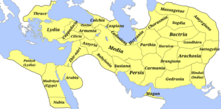
| Descripció | A map of the satraps of the Achaemenid Empire showing their ancient names and the extent of their territory. (Borders are approximate.) | ||
| Data | |||
| Font |
Treball propi
Atlas Antiquus. Atlas zur Geschichte des Altertums. Gotha: Justus Perthes, 1909. (File)
And Design structure and overview: ACHAEMENID SATRAPIES. ENCYCLOPÆDIA IRANICA. Archived from the original on 2022-03-26. Retrieved on 2023-08-15.
File:Map of the Achaemenid Empire.jpg
|
||
| Autor | M.r ebrahim zadeh | ||
| Permís (Com reutilitzar aquest fitxer) |
|
||
| Altres versions |
Fa: Map of Achaemenid Imperial Satraps(fa)
1- File:Bābiruš (Satrapy of the Achaemenid Empire).png |
.png)
.png)
.png)
.png)
.png)
.png)
.png)
.png)
.png)
.png)
.png)
.png)
.png)
.png)
.png)
.png)
.png)
Llicència
- Sou lliure de:
- compartir – copiar, distribuir i comunicar públicament l'obra
- adaptar – fer-ne obres derivades
- Amb les condicions següents:
- reconeixement – Heu de donar la informació adequada sobre l'autor, proporcionar un enllaç a la llicència i indicar si s'han realitzat canvis. Podeu fer-ho amb qualsevol mitjà raonable, però de cap manera no suggereixi que l'autor us dóna suport o aprova l'ús que en feu.
- compartir igual – Si modifiqueu, transformeu, o generareu amb el material, haureu de distribuir les vostres contribucions sota una llicència similar o una de compatible com l'original
- ↑ cartography: Mohammad Pourkamal Drawing maps with the cooperation of selected employees of the drawing department of the organization Mapping and Geography Institute under the supervision of: Ebrahim Khalil Majidian Printing of maps in cooperation with the printing department of the Mapping Organization under the supervision of Shmuel Josephnia Prepared by: Institute of Geography, University of Tehran Persian writings: Mohammad Taghi Sarmast
Historial del fitxer
Cliqueu una data/hora per veure el fitxer tal com era aleshores.
| Data/hora | Miniatura | Dimensions | Usuari/a | Comentari | |
|---|---|---|---|---|---|
| actual | 11:28, 15 ago 2023 | | 3.308 × 1.648 (653 Ko) | M.r ebrahim zadeh | Uploaded own work with UploadWizard |
Ús del fitxer
Les 2 pàgines següents utilitzen aquest fitxer:
Ús global del fitxer
Utilització d'aquest fitxer en altres wikis:
- Utilització a bs.wikipedia.org
- Utilització a en.wikipedia.org
- Utilització a es.wikipedia.org
- Utilització a fa.wikipedia.org
- Utilització a it.wikipedia.org
- Frigia
- Paflagonia
- Nubia
- XXVII dinastia egizia
- Cilicia
- Corasmia
- Battriana
- Impero achemenide
- Caria
- Ionia
- Colchide
- Sogdiana
- Aracosia
- Regno di Gandhāra
- Arabia (satrapia)
- Partia
- Libia (satrapia)
- Cappadocia (satrapia)
- Lidia (satrapia)
- Media (satrapia)
- Ircania
- Armenia persiana
- Babilonia (provincia persiana)
- Carmania
- Assiria persiana
- Maka (satrapia)
- Margiana
- Satrapo
- Satrapie achemenidi
- Aria (satrapia)
- Gedrosia
- Drangiana
- Susiana
- Template:Province dell'Impero achemenide
- Sattagidia
- India (satrapia)
- Transeufratene
- Utilització a ja.wikipedia.org
- Utilització a ru.wikipedia.org
.png)