
Fitxer:Map of Burzenland, 1959.jpg
Mida d'aquesta previsualització: 367 × 599 píxels. Altres resolucions: 147 × 240 píxels | 294 × 480 píxels | 470 × 768 píxels | 1.270 × 2.073 píxels.
Fitxer original (1.270 × 2.073 píxels, mida del fitxer: 1,99 Mo, tipus MIME: image/jpeg)
| Aquest fitxer i la informació mostrada a continuació provenen del dipòsit multimèdia lliure Wikimedia Commons. |
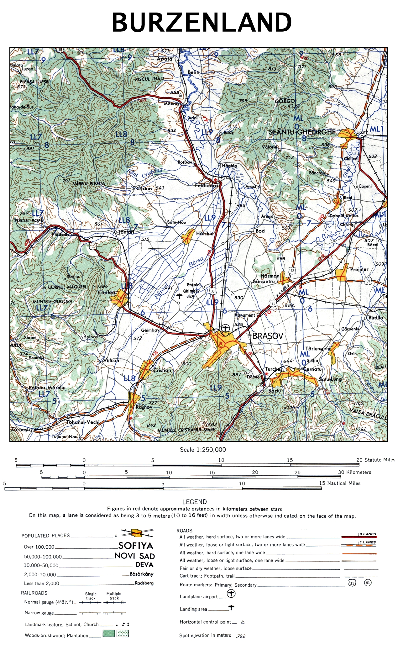
| Descripció | The map of Burzenland, Romania. |
| Data | |
| Font | University of Texas Libraries |
| Autor | US Army Map Service, Corps of Engineers |
| Altres versions |

This image or file is a work of a U.S. Army Corps of Engineers soldier or employee, taken or made as part of that person's official duties. As a work of the U.S. federal government, the image is in the public domain.
|
Historial del fitxer
Cliqueu una data/hora per veure el fitxer tal com era aleshores.
| Data/hora | Miniatura | Dimensions | Usuari/a | Comentari | |
|---|---|---|---|---|---|
| actual | 23:48, 12 nov 2009 | | 1.270 × 2.073 (1,99 Mo) | Alex:D | {{Information |Description= The map of Burzenland, Romania. |Source= [http://www.lib.utexas.edu/maps/ams/western_europe/ University of Texas Libraries] |Date= 1959 |Author= US Army Map Service, Corps of Engineers |Permission= |other_versions={{ExtractedFr |
Ús del fitxer
La pàgina següent utilitza aquest fitxer:
Ús global del fitxer
Utilització d'aquest fitxer en altres wikis:
- Utilització a cs.wikipedia.org
- Utilització a da.wikipedia.org
- Utilització a de.wikipedia.org
- Utilització a en.wikipedia.org
- Utilització a es.wikipedia.org
- Utilització a fr.wikipedia.org
- Utilització a hu.wikipedia.org
- Utilització a it.wikipedia.org
- Utilització a ja.wikipedia.org
- Utilització a pl.wikipedia.org
- Utilització a ru.wikipedia.org
- Utilització a sk.wikipedia.org
- Utilització a zh.wikipedia.org