
Fitxer:Map of the Territory of the Cornovii (Midlands).svg

Mida d'aquesta previsualització PNG del fitxer SVG: 466 × 599 píxels. Altres resolucions: 187 × 240 píxels | 373 × 480 píxels | 597 × 768 píxels | 796 × 1.024 píxels | 1.593 × 2.048 píxels | 700 × 900 píxels.
Fitxer original (fitxer SVG, nominalment 700 × 900 píxels, mida del fitxer: 117 Ko)
| Aquest fitxer i la informació mostrada a continuació provenen del dipòsit multimèdia lliure Wikimedia Commons. |
.svg?uselang=ca)
| Descripció |
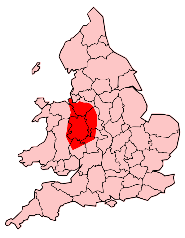
English: A map showing the territory of the Cornovii tribe overlayed in red in the context of the modern county boundaries of England and Wales |
| Data | (UTC) |
| Font | |
| Autor |
|
| Altres versions | Derivative works of this file: Map of the Territory of the Dobunni.svg |
.png)
Jo, el titular dels drets d'autor d'aquest treball, el public sota les següents llicències:
Aquest fitxer està subjecte a la llicència de Creative Commons Reconeixement i Compartir Igual 3.0 No adaptada.
- Sou lliure de:
- compartir – copiar, distribuir i comunicar públicament l'obra
- adaptar – fer-ne obres derivades
- Amb les condicions següents:
- reconeixement – Heu de donar la informació adequada sobre l'autor, proporcionar un enllaç a la llicència i indicar si s'han realitzat canvis. Podeu fer-ho amb qualsevol mitjà raonable, però de cap manera no suggereixi que l'autor us dóna suport o aprova l'ús que en feu.
- compartir igual – Si modifiqueu, transformeu, o generareu amb el material, haureu de distribuir les vostres contribucions sota una llicència similar o una de compatible com l'original

|
S'autoritza la còpia, la distribució i la modificació d'aquest document sota els termes de la llicència de documentació lliure GNU versió 1.2 o qualsevol altra versió posterior que publiqui la Free Software Foundation; sense seccions invariants, ni textos de portada, ni textos de contraportada. S'inclou una còpia d'aquesta llicència en la secció titulada GNU Free Documentation License. |
Podeu seleccionar la llicència que vulgueu.
Registre original de càrregues
This image is a derivative work of the following images:
- File:Map_of_the_Territory_of_the_Cornovii_(Midlands).png licensed with Cc-by-sa-3.0, GFDL
- 2009-06-14T22:37:16Z Jpb1301 737x873 (128895 Bytes) {{Information |Description={{en|1=A map showing the territory of the Cornovii tribe overlayed in red in the context of the modern county boundaries of England and wales}} |Source=Own work by uploader |Author=[[User:Jpb1301|Jp
Uploaded with derivativeFX
Historial del fitxer
Cliqueu una data/hora per veure el fitxer tal com era aleshores.
| Data/hora | Miniatura | Dimensions | Usuari/a | Comentari | |
|---|---|---|---|---|---|
| actual | 23:34, 7 abr 2013 | | 700 × 900 (117 Ko) | Alphathon | cropped |
| 02:09, 25 set 2009 |  | 744 × 1.052 (150 Ko) | Jpb1301 | {{Information |Description={{en|1=A map showing the territory of the Cornovii tribe overlayed in red in the context of the modern county boundaries of England and wales}} |Source=*File:Map_of_the_Territory_of_the_Cornovii_(Midlands).png |Date=2009-0 |
.png)
Ús del fitxer
No hi ha pàgines que utilitzin aquest fitxer.
Ús global del fitxer
Utilització d'aquest fitxer en altres wikis:
- Utilització a br.wikipedia.org
- Utilització a cy.wikipedia.org
- Utilització a en.wikipedia.org
- Utilització a en.wiktionary.org
- Utilització a fr.wikipedia.org
- Utilització a it.wikipedia.org
- Utilització a la.wikipedia.org
- Utilització a pt.wikipedia.org
.svg)