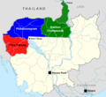
Fitxer:Provinces of Cambodia loss to Thailand during Franco-Thai War.png

Mida d'aquesta previsualització: 800 × 600 píxels. Altres resolucions: 320 × 240 píxels | 640 × 480 píxels | 1.024 × 768 píxels | 1.200 × 900 píxels.
Fitxer original (1.200 × 900 píxels, mida del fitxer: 187 Ko, tipus MIME: image/png)
Historial del fitxer
Cliqueu una data/hora per veure el fitxer tal com era aleshores.
| Data/hora | Miniatura | Dimensions | Usuari/a | Comentari | |
|---|---|---|---|---|---|
| actual | 06:48, 23 jul 2017 |  | 1.200 × 900 (187 Ko) | Aquapatinth | change - southern border of Phibulsongkhram and Nakhon Champassak Provinces to the 13.5th parallel and - southeastern border of Phibulsongkhram to meridian line from the point which border line between Siem Reap and Battanbang Province met Tonle Sap.... |
| 09:19, 16 feb 2016 |  | 1.001 × 921 (303 Ko) | Xufanc | corrected spelling | |
| 07:49, 12 feb 2016 |  | 1.001 × 921 (303 Ko) | Xufanc | Added missing part of Nakhon Champassak Province | |
| 19:46, 25 set 2014 |  | 1.000 × 903 (308 Ko) | RJFF | Somehow the revert did not work. | |
| 19:38, 25 set 2014 |  | 1.000 × 903 (308 Ko) | RJFF | Reverted to version as of 17:36, 25 September 2014 | |
| 19:37, 25 set 2014 |  | 1.000 × 903 (308 Ko) | RJFF | Reverted to version as of 18:43, 30 December 2013 | |
| 19:36, 25 set 2014 |  | 1.000 × 903 (308 Ko) | RJFF | Reverted to version as of 18:43, 30 December 2013: The other version seems to be more accurate, see [http://daravireak.files.wordpress.com/2012/10/map_thailand_3province_indochine.png here], [http://www.websitesrcg.com/border/maps/indochina-1942.jpg he... | |
| 17:32, 9 feb 2014 |  | 1.000 × 903 (321 Ko) | Murashel | In Peace treaty in Tokyo Thais gain territory of Koh Kong. | |
| 20:43, 30 des 2013 |  | 1.000 × 903 (308 Ko) | Derkommander0916 | Thailand never took Koh Kong and Pursat Refer this: http://www.geographicus.com/P/AntiqueMap/Thailand-japanese-1943 | |
| 17:01, 9 juny 2013 |  | 1.000 × 903 (321 Ko) | Murashel | User created page with UploadWizard |
Ús del fitxer
La pàgina següent utilitza aquest fitxer:
Ús global del fitxer
Utilització d'aquest fitxer en altres wikis:
- Utilització a en.wikipedia.org
- Utilització a es.wikipedia.org
- Utilització a fa.wikipedia.org
- Utilització a fr.wikipedia.org
- Utilització a he.wikipedia.org
- Utilització a it.wikipedia.org
- Utilització a ja.wikipedia.org
- Utilització a km.wikipedia.org
- Utilització a lo.wikipedia.org
- Utilització a nl.wikipedia.org
- Utilització a pl.wikipedia.org
- Utilització a ru.wikipedia.org
- Utilització a th.wikipedia.org
- Utilització a vi.wikipedia.org
- Utilització a zh.wikipedia.org


