
Fitxer:SFO map.png
No hi ha cap versió amb una resolució més gran.
SFO_map.png (405 × 583 píxels, mida del fitxer: 57 Ko, tipus MIME: image/png)
| Aquest fitxer i la informació mostrada a continuació provenen del dipòsit multimèdia lliure Wikimedia Commons. |
Resum
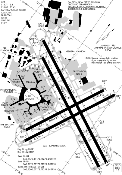
Detail from FAA diagram of San Francisco International Airport. Warning, this diagram contains material which is subject to change, do not use for navigation. There is also at least one error. The text block in the lower left gives lengths for runway "10L-18R." The runway designation should be "10L-28R."
Llicència
This image or file is a work of a Federal Aviation Administration employee, taken or made as part of that person's official duties. As a work of the U.S. federal government, the image is in the public domain in the United States.
|
 |
Historial del fitxer
Cliqueu una data/hora per veure el fitxer tal com era aleshores.
| Data/hora | Miniatura | Dimensions | Usuari/a | Comentari | |
|---|---|---|---|---|---|
| actual | 01:14, 17 des 2005 | | 405 × 583 (57 Ko) | Sam916~commonswiki | ==Summary== Detail from FAA diagram of San Francisco International Airport. Warning, this diagram contains material which is subject to change, do not use for navigation. ==Licensing== {{PD-USGov-FAA}} |
Ús del fitxer
La pàgina següent utilitza aquest fitxer:
Ús global del fitxer
Utilització d'aquest fitxer en altres wikis:
- Utilització a de.wikipedia.org
- Utilització a fr.wikipedia.org
- Utilització a he.wikipedia.org
- Utilització a id.wikipedia.org
- Utilització a ja.wikipedia.org
- Utilització a mr.wikipedia.org
- Utilització a ms.wikipedia.org
- Utilització a ta.wikipedia.org
- Utilització a th.wikipedia.org
- Utilització a vi.wikipedia.org