
Fitxer:Sogn og Fjordane Municipalities.png
Mida d'aquesta previsualització: 800 × 487 píxels. Altres resolucions: 320 × 195 píxels | 640 × 390 píxels | 1.025 × 624 píxels.
Fitxer original (1.025 × 624 píxels, mida del fitxer: 29 Ko, tipus MIME: image/png)
| Aquest fitxer i la informació mostrada a continuació provenen del dipòsit multimèdia lliure Wikimedia Commons. |

|
Aquesta imatge (de tipus locator map) s'hauria de tornar a crear utilitzant gràfics vectorials com ara un fitxer SVG. Això té diversos avantatges; en trobareu més informació a Commons:Media for cleanup. Si ja disposeu d'una versió d'aquesta imatge en format SVG, us preguem que la pengeu; després, reemplaceu aquesta plantilla amb la plantilla {{Vector version available|nom nou de la imatge.svg}} en aquesta imatge.
|
Transferred from en.wikipedia to Commons by Maksim.
La pàgina de descripció original era aquí. Els noms d'usuari a continuació es refereixen a en.wikipedia.
Resum
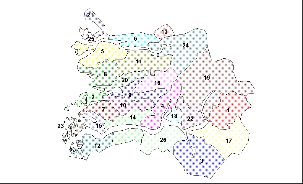
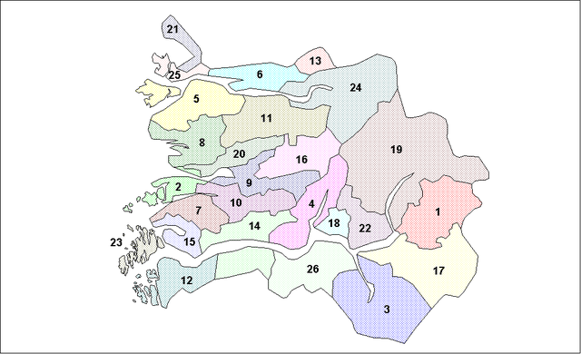
Map of the municipalities of Sogn og Fjordane County in Norway. Created by Rarelibra for public domain use. Created using MapInfo Professional v7.5 and various mapping resources.
Llicència
| Jo, el titular del copyright d'aquesta obra, l'allibero al domini públic. Això s'aplica a tot el món. En alguns països això pot no ser legalment possible, en tal cas: Jo faig concessió a tothom del dret d'usar aquesta obra per a qualsevol propòsit, sense cap condició llevat d'aquelles requerides per la llei. |
| date/time | username | edit summary |
|---|---|---|
| 14:58, 26 January 2006 | en:User:Rarelibra | (Map of the municipalities of Sogn og Fjordane County in Norway. Created by <a href="/wiki/User:Rarelibra" title="User:Rarelibra">Rarelibra</a> for public domain use. Created using MapInfo Professional v7.5 and various mapping resources.) |
Registre original de càrregues
Legend: (cur) = this is the current file, (del) = delete this old version, (rev) = revert to this old version.
Click on date to download the file or see the image uploaded on that date.
- (del) (cur) 18:36, 26 January 2006 . . en:User:Rarelibra Rarelibra ( en:User_talk:Rarelibra Talk) . . 1025x624 (30045 bytes) (Map of the municipalities of Sogn og Fjordane County in Norway. Created by en:User:Rarelibra Rarelibra for public domain use. Created using MapInfo Professional v7.5 and various mapping resources.)
- (del) (rev) 14:58, 26 January 2006 . . en:User:Rarelibra Rarelibra ( en:User_talk:Rarelibra Talk) . . 1025x624 (30510 bytes) (Map of the municipalities of Sogn og Fjordane County in Norway. Created by en:User:Rarelibra Rarelibra for public domain use. Created using MapInfo Professional v7.5 and various mapping resources.)
Historial del fitxer
Cliqueu una data/hora per veure el fitxer tal com era aleshores.
| Data/hora | Miniatura | Dimensions | Usuari/a | Comentari | |
|---|---|---|---|---|---|
| actual | 10:57, 26 març 2006 | | 1.025 × 624 (29 Ko) | Maksim | La bildo estas kopiita de wikipedia:en. La originala priskribo estas: == Summary == Map of the municipalities of Sogn og Fjordane County in Norway. Created by Rarelibra for public domain use. Created using MapInfo Professional v7.5 and |
Ús del fitxer
No hi ha pàgines que utilitzin aquest fitxer.
Ús global del fitxer
Utilització d'aquest fitxer en altres wikis:
- Utilització a bat-smg.wikipedia.org
- Utilització a en.wikipedia.org
- Utilització a eo.wikipedia.org
- Utilització a es.wikipedia.org
- Utilització a et.wikipedia.org
- Utilització a eu.wikipedia.org
- Utilització a hr.wikipedia.org
- Utilització a hu.wikipedia.org
- Utilització a id.wikipedia.org
- Utilització a ja.wikipedia.org
- Utilització a ka.wikipedia.org
- Utilització a ko.wikipedia.org
- Utilització a lt.wikipedia.org
- Utilització a nl.wikipedia.org
- Utilització a pt.wikipedia.org
- Utilització a ru.wikipedia.org
- Utilització a sr.wikipedia.org
- Utilització a sw.wikipedia.org
- Utilització a uk.wikipedia.org
- Utilització a vi.wikipedia.org
- Utilització a zea.wikipedia.org
- Utilització a zh.wikipedia.org