
Fitxer:Solomon Islands 1989.jpg
Mida d'aquesta previsualització: 750 × 600 píxels. Altres resolucions: 300 × 240 píxels | 600 × 480 píxels | 961 × 768 píxels | 1.203 × 962 píxels.
Fitxer original (1.203 × 962 píxels, mida del fitxer: 131 Ko, tipus MIME: image/jpeg)
| Aquest fitxer i la informació mostrada a continuació provenen del dipòsit multimèdia lliure Wikimedia Commons. |
Resum
| Descripció |
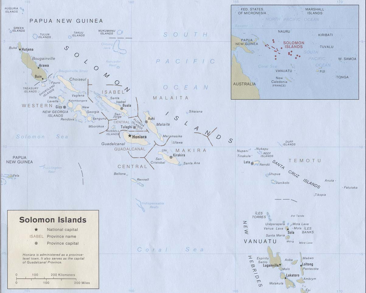
English: Map of the Solomon Islands as of 1989. Province names are included, except for two new provinces as of 1995: the Rennell and Bellona Province (formerly part of Central Province) and the Choiseul Province (formerly part of Western Province). |
| Data | |
| Font | Solomon Islands (Political) 1989 from Perry-Castañeda Library Map Collection: Solomon Islands Maps. Cropped to remove white space from edges of map. |
| Autor | U.S. Central Intelligence Agency |
| Permís (Com reutilitzar aquest fitxer) |
Public domain |
Llicència
| This image is a work of a Central Intelligence Agency employee, taken or made as part of that person's official duties. As a Work of the United States Government, this image or media is in the public domain in the United States.
|

|
Historial del fitxer
Cliqueu una data/hora per veure el fitxer tal com era aleshores.
| Data/hora | Miniatura | Dimensions | Usuari/a | Comentari | |
|---|---|---|---|---|---|
| actual | 21:27, 25 ago 2009 | | 1.203 × 962 (131 Ko) | Zyxw | == {{int:filedesc}} == {{Information | description = {{en|Map of the Solomon Islands as of 1989. Province names are included, except for two new provinces as of 1995: the [[:en:Rennell and B |
Ús del fitxer
La pàgina següent utilitza aquest fitxer:
Ús global del fitxer
Utilització d'aquest fitxer en altres wikis:
- Utilització a af.wikipedia.org
- Utilització a ar.wikipedia.org
- Utilització a az.wiktionary.org
- Utilització a bg.wikipedia.org
- Utilització a br.wikipedia.org
- Utilització a cs.wikipedia.org
- Utilització a en.wikipedia.org
- Utilització a es.wikipedia.org
- Utilització a eu.wikipedia.org
- Utilització a fr.wikipedia.org
- Utilització a gl.wikipedia.org
- Utilització a hr.wikipedia.org
- Utilització a hu.wikipedia.org
- Utilització a hy.wikipedia.org
- Utilització a id.wikipedia.org
- Utilització a pa.wikipedia.org
- Utilització a pl.wikipedia.org
- Utilització a pl.wiktionary.org
- Utilització a pt.wikipedia.org
- Utilització a ro.wikipedia.org
- Utilització a ru.wikipedia.org
- Utilització a sco.wikipedia.org
- Utilització a simple.wikipedia.org
- Utilització a su.wikipedia.org
- Utilització a tpi.wikipedia.org
- Utilització a tr.wikipedia.org
- Utilització a uk.wikipedia.org
- Utilització a wuu.wikipedia.org
Vegeu més usos globals d'aquest fitxer.