
Fitxer:Sunokobashi Tailings Dam survey 1976.jpg

Mida d'aquesta previsualització: 451 × 600 píxels. Altres resolucions: 180 × 240 píxels | 361 × 480 píxels | 669 × 890 píxels.
Fitxer original (669 × 890 píxels, mida del fitxer: 121 Ko, tipus MIME: image/jpeg)
| Aquest fitxer i la informació mostrada a continuació provenen del dipòsit multimèdia lliure Wikimedia Commons. |
Resum
| Descripció |
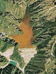
English: Sunokobashi Tailings Dam in Ashio copper mine.
日本語: 足尾銅山の簀子橋堆積場。 |
| Data | |
| Font | Japan Ministry of Land, Infrastructure and Transport. [1] |
| Autor | Retouch: Qurren (talk). |
| Altres versions |
.jpg)
| Posició de la càmera | | Aquesta i altres imatges properes a: OpenStreetMap |
|---|
Llicència

|
El titular dels drets d'autor d'aquest arxiu, the Ministry of Land, Infrastructure, Transport and Tourism of Japan, permet que qualsevol pugui usar-lo per a qualsevol propòsit, sempre que el titular dels drets d'autor sigui reconegut correctament. La redistribució, les obres derivades, l'ús comercial, i qualsevol altre ús està permès. |
Reconeixement:
Copyright © National Land Image Information (Color Aerial Photographs), Ministry of Land, Infrastructure, Transport and Tourism
|
 |
This image is copyrighted by the Ministry of Land, Infrastructure, Transport and Tourism of Japan. For terms of use, see the stipulation to use of National Land Information (in Japanese) and message from MLIT (in Japanese and English). When you display this image on an article, include the following phrase in the description: "Made based on National Land Image Information (Color Aerial Photographs), Ministry of Land, Infrastructure, Transport and Tourism".
|
Historial del fitxer
Cliqueu una data/hora per veure el fitxer tal com era aleshores.
| Data/hora | Miniatura | Dimensions | Usuari/a | Comentari | |
|---|---|---|---|---|---|
| actual | 13:22, 17 des 2009 | | 669 × 890 (121 Ko) | Qurren | {{Information |Description={{en|1=Sunokobashi Tailings Dam in en:Ashio copper mine.}} {{ja|1=ja:足尾銅山の簀子橋堆積場。}} |Source=Japan Ministry of Land, Infrastructure and Transport. [http://w3land.mlit.go.jp/cgi-bin/WebGIS2/WC_A |
Ús del fitxer
La pàgina següent utilitza aquest fitxer:
Ús global del fitxer
Utilització d'aquest fitxer en altres wikis:
- Utilització a fr.wikipedia.org
- Utilització a ja.wikipedia.org