
Fitxer:Tlaxcalamap.jpg
Fitxer original (3.840 × 3.000 píxels, mida del fitxer: 2,24 Mo, tipus MIME: image/jpeg)
| Aquest fitxer i la informació mostrada a continuació provenen del dipòsit multimèdia lliure Wikimedia Commons. |
Resum
| Descripció |
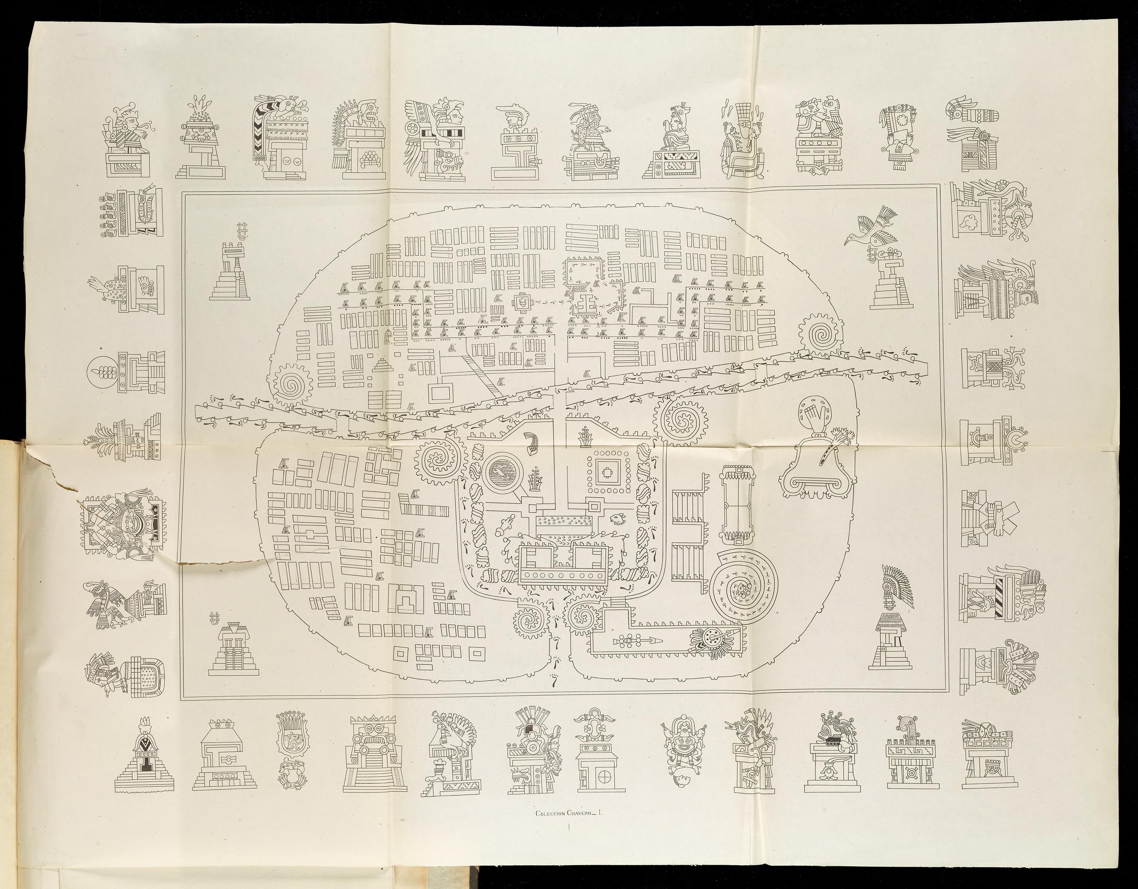
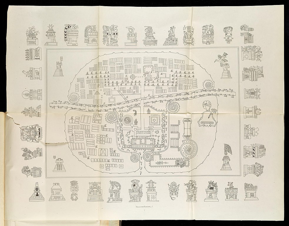
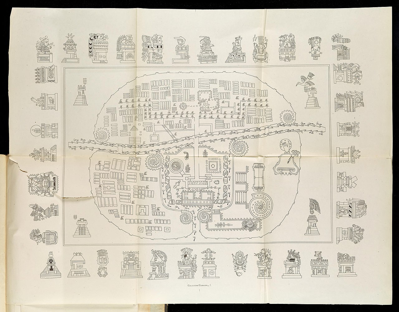
English: A Map of Tlaxcala: The top-right hand sector is Tizatlan, the bottom-right hand sector Quiahuiztlan, the top-left hand sector Ocotelolco, and the bottom-left hand sector Tepeticpac. The river, Atzompa, crosses the city from North to South (left to right, the map being oriented along an East-West axis).
Italiano: Mappa di Tlaxcala.Il settore in alto a destra è Tizatlan, quello in basso a destra è Quiahuiztlan, quello in alto a sinistra è Ocotelolco e quello in basso a sinistra è Tepeticpac. Il fiume, Atzompa, attraversa la città da nord a sud (da sinistra a destra, dato che la mappa è orientata sull'asse est-ovest). Tratta da Alfredo Chavero, Pintures Jeroglificas, Messico, 1901. |
| Data | |
| Font | Pinturas Jeroglíficas, Mexico: https://archive.org/details/gri_33125009867314 |
| Autor | Alfredo Chavero |
Llicència
|
Aquest material està en domini públic als Estats Units i als altres països on el dret d'autor s'estén per 70 anys (o menys) després de la mort de l'autor.
| |
| Aquest fitxer està identificat com a lliure de restriccions conegudes sota la llei de drets d'autor, inclosos els drets veïns. | |
Registre original de càrregues
- 2009-07-06 03:43 Robert M Johnson 871×663× (693169 bytes) == Description == {{Information |Description= Map of the [[Nahuatl]] city [[Tlaxcala]] from the 20th century, |Source=Originally from [http://books.google.com/books?id=o-sMQAovYJoC&pg=PA461&lpg=PA461&dq=Tepeticpac+tlaxcala&source=bl&ots=1y1yM9xzIM&sig=u6
Historial del fitxer
Cliqueu una data/hora per veure el fitxer tal com era aleshores.
| Data/hora | Miniatura | Dimensions | Usuari/a | Comentari | |
|---|---|---|---|---|---|
| actual | 11:50, 17 juny 2022 | | 3.840 × 3.000 (2,24 Mo) | ErickTErick | Better version from the same source |
| 16:08, 21 nov 2009 |  | 871 × 663 (677 Ko) | File Upload Bot (Magnus Manske) | {{BotMoveToCommons|en.wikipedia|year={{subst:CURRENTYEAR}}|month={{subst:CURRENTMONTHNAME}}|day={{subst:CURRENTDAY}}}} {{Information |Description={{en|''no original description''}} |Source=Transferred from [http://en.wikipedia.org en.wikipedia]; transfer |
Ús del fitxer
La pàgina següent utilitza aquest fitxer:
Ús global del fitxer
Utilització d'aquest fitxer en altres wikis:
- Utilització a af.wikipedia.org
- Utilització a arz.wikipedia.org
- Utilització a cs.wikipedia.org
- Utilització a en.wikipedia.org
- Utilització a eo.wikipedia.org
- Utilització a es.wikipedia.org
- Utilització a it.wikipedia.org
- Utilització a ja.wikipedia.org
- Utilització a pl.wikipedia.org
- Utilització a uk.wikipedia.org
- Utilització a www.wikidata.org