
Fitxer:USGS-PlanetMars-TopographicalMap.png

Mida d'aquesta previsualització: 800 × 367 píxels. Altres resolucions: 320 × 147 píxels | 640 × 294 píxels | 1.024 × 470 píxels | 1.280 × 587 píxels | 2.560 × 1.174 píxels | 10.292 × 4.720 píxels.
Fitxer original (10.292 × 4.720 píxels, mida del fitxer: 6,72 Mo, tipus MIME: image/png)
| Aquest fitxer i la informació mostrada a continuació provenen del dipòsit multimèdia lliure Wikimedia Commons. |
Resum
| Descripció |
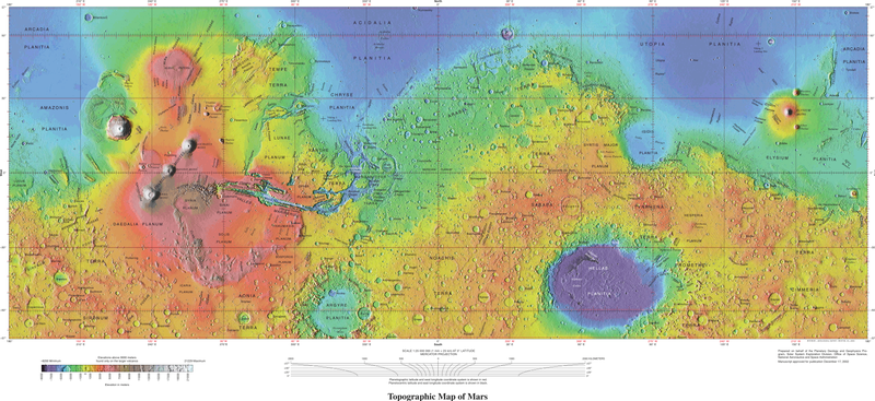
English: USGS - Planet Mars - Topographical Map - 1-24-2005 - Geologic Investigations Series I-2782 These maps are based on data from the Mars Orbiter Laser Altimeter (MOLA; Smith and others, 2001), an instrument on NASA’s Mars Global Surveyor (MGS) spacecraft (Albee and others, 2001). The image used for the base of this map represents more than 600 million measurements gathered between 1999 and 2001, adjusted for consistency (Neumann and others, 2001, 2003) and converted to planetary radii. These have been converted to elevations above the areoid as determined from a martian gravity field solution GMM-2B (Lemoine and others, 2001), truncated to degree and order 50, and oriented according to current standards (see below). The average accuracy of each point is originally ~100 meters in horizontal position and ~1 meter in radius (Neumann and others, 2001). However, the total elevation uncertainty is at least ±3 m due to the global error in the areoid (±1.8 meters according to Lemoine and others [2001]) and regional uncertainties in its shape (G.A. Neumann, written commun., 2002). The measurements were converted into a digital elevation model (DEM; G.A. Neumann, written commun., 2002; Neumann and others, 2001; Smith and others 2001) using Generic Mapping Tools software (Wessel and Smith, 1998), with a resolution of 0.015625 degree per pixel or 64 pixels per degree. In projection, the pixels are 926.17 meters in size at the equator. Data are very sparse near the two poles (above 87° north and below 87° south latitude) because these areas were sampled by only a few off-nadir altimetry tracks. Gaps between tracks of 1–2 km are common, and some gaps of up to 12 km occur near the equator. DEM points located in these gaps in MOLA data were filled by interpolation. |
| Data | |
| Font | https://pubs.usgs.gov/imap/i2782/; https://pubs.usgs.gov/imap/i2782/i2782_sh1.pdf |
| Autor | U.S. Geological Survey |
| Altres versions |
|


Llicència
Aquesta imatge és de domini públic, ja que conté materials que originalment van venir del Servei Geològic dels Estats Units d'Amèrica, una agència del Departament de l'Interior dels Estats Units. Per a obtenir més informació, consulti la política oficial de drets de l'USGS.
|
| Aquest fitxer és en el domini públic perquè ha estat creat per la NASA. L'avís legal de la NASA diu que «el material de la NASA no està protegit per copyright si no es diu el contrari». (NASA copyright policy page o JPL Image Use Policy). | ||
 |
Atenció:
|
Historial del fitxer
Cliqueu una data/hora per veure el fitxer tal com era aleshores.
| Data/hora | Miniatura | Dimensions | Usuari/a | Comentari | |
|---|---|---|---|---|---|
| actual | 20:11, 4 oct 2021 | | 10.292 × 4.720 (6,72 Mo) | Cherurbino | same 256 clr, larger size + legend |
| 02:19, 16 maig 2019 |  | 7.245 × 3.204 (11,38 Mo) | Huntster | Crop from original, manually trim out right side text, push title text up a bit. | |
| 04:14, 15 maig 2019 |  | 3.472 × 1.544 (7,43 Mo) | Drbogdan | User created page with UploadWizard |
Ús del fitxer
No hi ha pàgines que utilitzin aquest fitxer.
Ús global del fitxer
Utilització d'aquest fitxer en altres wikis:
- Utilització a el.wikipedia.org
- Utilització a en.wikipedia.org
- Utilització a hr.wikipedia.org
- Utilització a ru.wikipedia.org
- Utilització a vi.wikipedia.org