
Fitxer:Vesuve-NASA.jpg

Mida d'aquesta previsualització: 601 × 600 píxels. Altres resolucions: 240 × 240 píxels | 481 × 480 píxels | 770 × 768 píxels | 1.026 × 1.024 píxels | 2.052 × 2.048 píxels | 4.089 × 4.081 píxels.
Fitxer original (4.089 × 4.081 píxels, mida del fitxer: 4,63 Mo, tipus MIME: image/jpeg)
| Aquest fitxer i la informació mostrada a continuació provenen del dipòsit multimèdia lliure Wikimedia Commons. |
Resum
| Descripció |
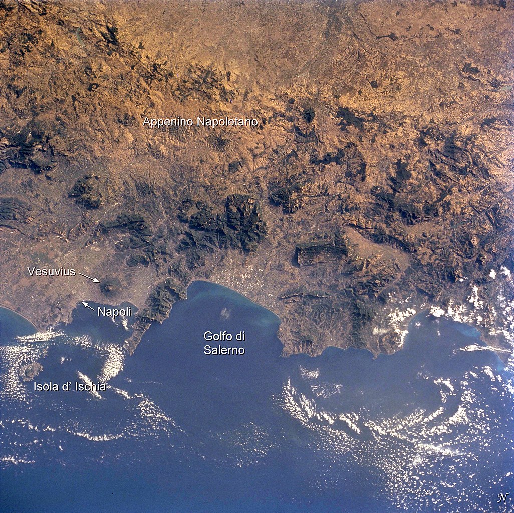
English: Photo of the bay of Naples and the Vesuvius vulcano, taken by Space Shuttle astronauts
Français : Photo satellite de la baie de Naples avec le Vésuve |
| Data | |
| Font | Earth Sciences and Image Analysis, NASA-Johnson Space Center. 16 Apr. 2004. "Earth from Space - Image Information." http://earth.jsc.nasa.gov/sseop/EFS/photoinfo.pl?PHOTO=STS104-710-60 |
| Autor |
NASA |
Aquest fitxer ha estat catalogat per una de les centrals dels Estats Units d'Amèrica per a l'Administració Nacional d'Aeronàutica i de l'Espai (NASA)en virtut identificat com a: ID del fitxer : STS104-710-60.Els ID dels fitxers i ID alternatius són traduïts de Photo ID .Aquesta etiqueta no indica l'estat dels drets d'autor de la imatge carregada. Cal un senyal de drets d'autor. Vegeu Commons:Sobre les llicències. Altres idiomes:
|
Llicència
This file is in the public domain in the United States because it was created by the Image Science & Analysis Laboratory, of the NASA Johnson Space Center. NASA copyright policy states that "NASA material is not protected by copyright unless noted". (NASA media use guidelines or Conditions of Use of Astronaut Photographs).
Photo source: STS104-710-60.
|
Registre original de càrregues
(All user names refer to fr.wikipedia)
- 2004-08-05 20:18 Nataraja 540×540×8 (100321 bytes) photo satellite de la baie avec le Vésuve
Historial del fitxer
Cliqueu una data/hora per veure el fitxer tal com era aleshores.
| Data/hora | Miniatura | Dimensions | Usuari/a | Comentari | |
|---|---|---|---|---|---|
| actual | 19:14, 2 des 2014 | | 4.089 × 4.081 (4,63 Mo) | Ras67 | with captions |
| 19:09, 2 des 2014 |  | 4.089 × 4.081 (4,55 Mo) | Ras67 | high resolution without captions | |
| 10:29, 6 feb 2007 |  | 540 × 540 (98 Ko) | Bilou~commonswiki | {{Information |Description=photo satellite de la baie de Naples avec le Vésuve |Source=Earth Sciences and Image Analysis, NASA-Johnson Space Center. 16 Apr. 2004. "Earth from Space - Image Information." http://earth.jsc.nasa.gov/sseop/EFS/photoinfo.pl?PH |
Ús del fitxer
La pàgina següent utilitza aquest fitxer:
Ús global del fitxer
Utilització d'aquest fitxer en altres wikis:
- Utilització a de.wikipedia.org
- Utilització a eo.wikipedia.org
- Utilització a fr.wikipedia.org
- Utilització a nl.wikipedia.org
- Utilització a rm.wikipedia.org