
Fitxer:WarRelocationMap.jpg

No hi ha cap versió amb una resolució més gran.
WarRelocationMap.jpg (628 × 408 píxels, mida del fitxer: 128 Ko, tipus MIME: image/jpeg)
| Aquest fitxer i la informació mostrada a continuació provenen del dipòsit multimèdia lliure Wikimedia Commons. |
Resum
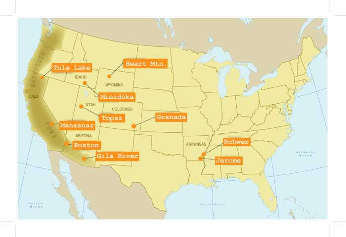
| Descripció | アメリカ合衆国日系人収容所所在地地図 |
| Font |
http://www.nps.gov/manz/historyculture/images/WarRelocationMap.jpg |
| Autor | The National Park Service (NPS), U.S. Department of the Interior |
Llicència
| This image or media file contains material based on a work of a National Park Service employee, created as part of that person's official duties. As a work of the U.S. federal government, such work is in the public domain in the United States. See the NPS website and NPS copyright policy for more information. |
Historial del fitxer
Cliqueu una data/hora per veure el fitxer tal com era aleshores.
| Data/hora | Miniatura | Dimensions | Usuari/a | Comentari | |
|---|---|---|---|---|---|
| actual | 18:20, 16 oct 2020 | | 628 × 408 (128 Ko) | WFinch | no crops |
| 17:08, 25 set 2006 |  | 700 × 480 (27 Ko) | Californiacondor~commonswiki | アメリカ合衆国日系人収容所所在地地図 |
Ús del fitxer
La pàgina següent utilitza aquest fitxer:
Ús global del fitxer
Utilització d'aquest fitxer en altres wikis:
- Utilització a en.wikipedia.org
- Utilització a fr.wikipedia.org
- Utilització a ja.wikipedia.org
- Utilització a www.wikidata.org