
Fitxer:World Soil pH.svg

Mida d'aquesta previsualització PNG del fitxer SVG: 800 × 406 píxels. Altres resolucions: 320 × 162 píxels | 640 × 325 píxels | 1.024 × 520 píxels | 1.280 × 650 píxels | 2.560 × 1.299 píxels | 940 × 477 píxels.
Fitxer original (fitxer SVG, nominalment 940 × 477 píxels, mida del fitxer: 6,43 Mo)
| Aquest fitxer i la informació mostrada a continuació provenen del dipòsit multimèdia lliure Wikimedia Commons. |
Resum
| Descripció |
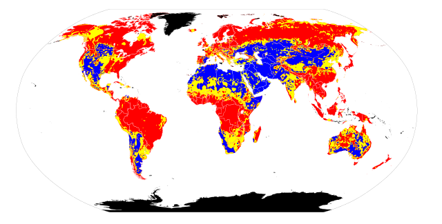
English: I retrieved the soil pH maps from [1]. In GIMP 2.4.3 I used the "Select by Color Tool" (threshold 15.0) to create pH-specific maps. Note that the original maps do not indicate actual pH values in the pH scale. For soils with acidic pH, I included the colors indicated by the leftmost 14 bars in the pH scale, ranging from red to pink. For soils with basic pH, I included the colors indicated by the rightmost 6 bars on the pH scale, ranging from light blue to blue. For soils with neutral pH, I included the remainder of the bars on the pH scale, which included very light pink, white, and very light blue. I then referenced these pH-specific maps to draw regions of differing soil pH on File:BlankMap-World6.svg. Because the original maps from Atlas of the Biosphere and File:BlankMap-World6.svg use different map projections, some ambiguity was introduced into this map. Thus it can only be taken to represent basic trends in soil pH, not precise boundaries.
|
|
| Data | ||
| Font | Treball propi | |
| Autor | Ninjatacoshell |
Llicència
Jo, el titular dels drets d'autor d'aquest treball, el public sota les següents llicències:
Aquest fitxer està subjecte a la llicència de Creative Commons Reconeixement i Compartir Igual 3.0 No adaptada.
- Sou lliure de:
- compartir – copiar, distribuir i comunicar públicament l'obra
- adaptar – fer-ne obres derivades
- Amb les condicions següents:
- reconeixement – Heu de donar la informació adequada sobre l'autor, proporcionar un enllaç a la llicència i indicar si s'han realitzat canvis. Podeu fer-ho amb qualsevol mitjà raonable, però de cap manera no suggereixi que l'autor us dóna suport o aprova l'ús que en feu.
- compartir igual – Si modifiqueu, transformeu, o generareu amb el material, haureu de distribuir les vostres contribucions sota una llicència similar o una de compatible com l'original

|
S'autoritza la còpia, la distribució i la modificació d'aquest document sota els termes de la llicència de documentació lliure GNU versió 1.2 o qualsevol altra versió posterior que publiqui la Free Software Foundation; sense seccions invariants, ni textos de portada, ni textos de contraportada. S'inclou una còpia d'aquesta llicència en la secció titulada GNU Free Documentation License. |
Podeu seleccionar la llicència que vulgueu.
Historial del fitxer
Cliqueu una data/hora per veure el fitxer tal com era aleshores.
| Data/hora | Miniatura | Dimensions | Usuari/a | Comentari | |
|---|---|---|---|---|---|
| actual | 08:16, 14 maig 2010 | | 940 × 477 (6,43 Mo) | Ninjatacoshell | {{Information |Description={{en|1=I retrieved the soil pH maps from [http://www.sage.wisc.edu/atlas/maps.php?datasetid=20&includerelatedlinks=1&dataset=20 Atlas of the Biosphere]. In GIMP 2.4.3 I used the "Select by Color Tool" (threshold 15.0) to create |
Ús del fitxer
La pàgina següent utilitza aquest fitxer:
Ús global del fitxer
Utilització d'aquest fitxer en altres wikis:
- Utilització a ar.wikipedia.org
- Utilització a bg.wikipedia.org
- Utilització a bn.wikipedia.org
- Utilització a de.wikipedia.org
- Utilització a en.wikipedia.org
- Utilització a eo.wikipedia.org
- Utilització a es.wikipedia.org
- Utilització a fa.wikipedia.org
- Utilització a fr.wikipedia.org
- Utilització a hi.wikipedia.org
- Utilització a hy.wikipedia.org
- Utilització a la.wikipedia.org
- Utilització a mn.wikipedia.org
- Utilització a nl.wikipedia.org
- Utilització a pt.wikipedia.org
- Utilització a uk.wikipedia.org
- Utilització a vi.wikipedia.org
- Utilització a zh.wikipedia.org