
Fitxer:Location Ryukyu Islands.PNG

Mida d'aquesta previsualització: 550 × 599 píxels. Altres resolucions: 220 × 240 píxels | 441 × 480 píxels | 906 × 987 píxels.
Fitxer original (906 × 987 píxels, mida del fitxer: 151 Ko, tipus MIME: image/png)
| Aquest fitxer i la informació mostrada a continuació provenen del dipòsit multimèdia lliure Wikimedia Commons. |
Resum
| Descripció |
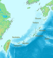
English: Location map of the Ryukyu islands (Nansei islands). According to the standardized geographical names of Japan, the Nansei Islands (南西諸島, Nansei Shotō, lit. "Southwest Islands") cover the entire island chain: the Ōsumi, Tokara, Amami, Okinawa, Sakishima Islands (further divided into the Miyako and Yaeyama Islands), the Senkaku Islands, and the Daitō Islands, with Yonaguni the westernmost. |
| Data | 2006, 2022 |
| Font | Treball propi |
| Autor | Nanshu, Michiel1972 |
| Altres versions | alternative version: File:Location of the Ryukyu Islands.JPG |
Llicència
This image is in the public domain because it came from the site https://www.demis.nl/products/web-map-server/examples/ and was released by the copyright holder. Permission is granted to copy, distribute and/or modify this map since it is based on free of copyright images from: www.demis.nl. See also approval email on de.wp and its clarification.
|
| This work has been released into the public domain by its copyright holder, www.demis.nl. This applies worldwide. En alguns països això pot no ser legalment possible, en tal cas: www.demis.nl concedeix a tothom el dret d'usar aquesta obra per a qualsevol propòsit, sense cap condició llevat d'aquelles requerides per la llei.
|
Historial del fitxer
Cliqueu una data/hora per veure el fitxer tal com era aleshores.
| Data/hora | Miniatura | Dimensions | Usuari/a | Comentari | |
|---|---|---|---|---|---|
| actual | 09:53, 21 maig 2022 | | 906 × 987 (151 Ko) | A1Cafel | Reverted to version as of 08:43, 3 April 2022 (UTC) |
| 09:26, 13 maig 2022 |  | 2.309 × 1.594 (527 Ko) | Sturmgewehr88 | Higher resolution map | |
| 10:43, 3 abr 2022 |  | 906 × 987 (151 Ko) | Nanshu | Adjust locations. Larger labels. | |
| 00:45, 20 gen 2006 |  | 482 × 377 (85 Ko) | Michiel1972 | *Location_Ryukyu_Islands {{demis}} |
Ús del fitxer
No hi ha pàgines que utilitzin aquest fitxer.
Ús global del fitxer
Utilització d'aquest fitxer en altres wikis:
- Utilització a ar.wikipedia.org
- Utilització a en.wikipedia.org
- Utilització a fr.wikipedia.org
- Utilització a hak.wikipedia.org
- Utilització a ro.wikipedia.org
- Utilització a sn.wikipedia.org
- Utilització a uk.wikipedia.org
- Utilització a zh-min-nan.wikipedia.org
- Utilització a zh-yue.wikipedia.org
- Utilització a zh.wikipedia.org